Tag Archives: GIS

22 Young Geospatial Professionals to Watch in 2022 – 3 of 22
Throughout January xyHt.com will feature the young geospatial professionals who are making a name for themselves in everything from surveying to geographic information systems. xyHt featured all of them in the January issue. Here we will spotlight one each day for the next 22 days. Name: Kate Berg Company: Michigan Department of Environment, Great Lakes,...

Digitizing for the Future
Street-level imagery and GIS technologies are turning Philadelphia into one smart city Major metropolises are racing to get ahead of technology that could bring driverless cars and delivery drones to their streets and skies. In Philadelphia, investments in new software and services are already paying dividends in other ways for many of its 1.6 million...

xyHt Magazine Digital Edition: December 2021
Like a good surveyor, xyHt‘s December issue covers a lot of ground. This month we bring you stories about surveying, lidar, legal issues and an in-depth look at the emerging post-processing kinematic technology. As always, if you don’t have a subscription to our print edition, or if someone else in the office has snaffled your copy,...

Preserving Florida’s Sea Turtles
Technology helps track endangered marine life, saving sea turtles one nest at a time The sun is barely rising above the water along the Florida coastline, but groups of people are already walking the beach, notebooks in hand, eyes focused on the sand, pausing, kneeling, pointing. They are here as they are every spring to...
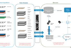
How Deep Learning For Remote Sensing Produces Quicker, Higher-Quality Results
As the volume, velocity, and variety of the data generated to address worldwide geospatial needs has steadily grown, advances in the systems and algorithms needed to produce spatial and temporal resolution data have not kept pace.

Thinking Ahead
From mapping catchments to inspecting dams, there’s a solid future for UAS technology at public utility companies like the Salt River Project in Arizona