Tag Archives: Harvey
Geospatial to the Rescue
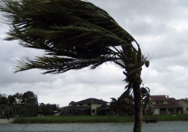
In view of recent weather-related events, we’ll take a quick detour from our series on AR (augmented reality) to cover RR (real reality): the catastrophic 2017 hurricane and wildfire season. The Caribbean islands, Florida, Louisiana, and Texas are reeling from the effects of hurricanes Harvey and Irma. As of this writing, Jose is only brushing...

xyHt Weekly News Links: 9/15/17
Tallysman introduces new high-gain GNSS antennas Taoglas launches comprehensive range of high-precision GNSS antennas NICB Makes Aerial Imagery from Harvey and Irma Available to Public Hazard and Evacuation Map Now Available for Hurricane Irma Affected Areas Drone swarm management software UgCS DDC enriched with ArtNET

Disaster Relief Fund for Surveyors
Surveyors helping surveyors. The National Society of Professional Surveyors (NSPS) Foundation Disaster Relief Fund is offering financial assistance for surveyors affected by the recent, multiple,and devastating, disasters—and seeks donations. Click here to see before and after images of Hurricane Harvey, courtesy of Woolpert; the ArcGIS Disaster Response Map showing the wildfires; and the National Hurricane...
xyHt Weekly News Links: 9/1/17
HP Unveils HP Mars Home Planet and New Wearable HP Z VR Backpack Icaros and Agrowing Announce Integrated Drone Multispectral Mapping Solution for Agriculture Crowdsourced Mapping Projects Aid Post-Harvey Disaster Management Start-up Wingtra Expands UAV Solutions to China and US Boundless Donates $100,000 to LaunchCode in Support of CoderGirl Education Program