By Ben Shinabery
Louisville’s massive Mega Caverns presented challenges for a huge subterranean survey
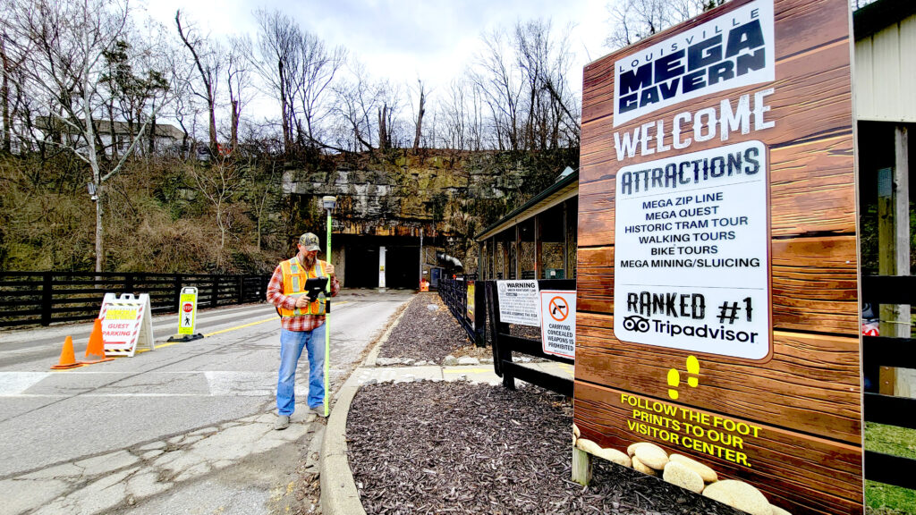
Every day more than 150,000 people drive past the interstate billboards advertising the Louisville Mega Caverns not realizing they just drove over what is classified as the largest commercial building in Kentucky, even though it is entirely underground.
What once was a massive subterranean limestone quarry in the heart of urban Louisville is now an environmentally conscious, high-security commercial storage facility that is so massive it contains the only fully underground aerial ropes challenge and zipline course in the world: The Louisville Mega Caverns.
History
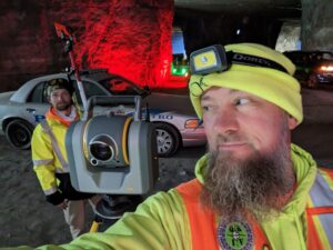
Matt Jenne & Steve Holliger setting the network of survey control and LiDAR targets
For 42 years in the middle of the 20th century, the cavern was mined to provide crushed stone to the growing Louisville metro area. With each blast and every truckload of stone removed, the underground cavern grew until the mining ended and the cavern covered 4 million square feet of space 75 to 100 feet below the surface. In 1989, private investors envisioned leasing climate-controlled storage between the 85- to 90-foot-tall rock pillars that were left to keep the mine from collapsing under the city. It is these structural pillars that classify the mine as a building.
The Mega Caverns began development through special zoning and building permits, creating a business model for the largest recycling center in Kentucky while erecting walls between pillars for individual lease areas. More than just commercial storage, the Mega Caverns wanted to give people unique underground experiences unlike anywhere else in the world. So, the owners created the Mega Zipline, an adventure ropes course called Mega Quest, and during the Christmas season an underground Christmas lights driving tour that is more than three miles long.
Through all this development, the Mega Cavern never had an accurate land survey relating the recorded legal descriptions to the excavated portions with precise measurements to the horizontal extents and the vertical ground and ceiling elevations.
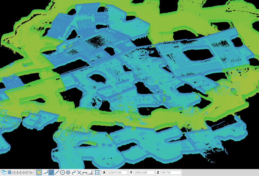
Underground storage buildings colorized in blue, truck routes in green, black voids in the data are rock columns between buildings
The Project
During the summer of 2022, the Mega Caverns hired Qk4, Inc. to perform an ALTA/NSPS Land Title Survey of the property boundaries and underground limits as well as a topographic survey of the interior portions of the cavern, including building walls, underground roadways, drainage sump pits, and the full zipline course.
Qk4 had worked on a few small-format scanning and design projects for this client and had previous awareness of the lease spaces but had never completed an underground boundary survey, and Louisville Metro Planning and Design Services had never reviewed and approved an underground minor subdivision plat for land division.
More than just a modern boundary survey, the commercial property updated its title insurance and needed a full ALTA/NSPS Land Title Survey to relate any title encumbrances affecting the property horizontally and vertically because of the elevation limits in the legal descriptions.
From previous work, Qk4 had some survey control, but it was going to take more than just a traverse and a few survey shots to capture every existing pillar and man-made improvement within the 100-acre site. The survey project team planned to use every modern survey tech advantage to capture a full 3D digital twin above ground and below.
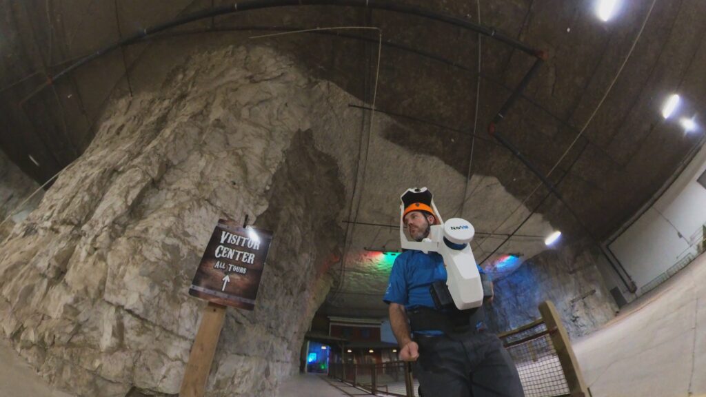
Ben Shinaberry collecting SLAM LiDAR of the visitor center
Ben Shinabery, PLS and vice president for land survey at Qk4, Inc., led the survey team. In the 10 months it took to complete the survey, 10 Qk4 survey team members spent 732 hours:
- Establishing a control network inside and out with 96 survey control points and 150 additional scanning targets tied to KY State Plane Coordinates, North Zone for future reference with Trimble R12i GNSS, and Trimble SX10 robotic total scanners for least squares adjustment processed in Trimble Business Center (TBC).
- Drafting rudimentary legal descriptions in poles using Carlson Survey running on AutoCAD Civil 3D, referencing historic property evidence on the above ground surface.
- 3D terrestrial scanning every accessible square foot of the interior of the cavern using Trimble SX10, x7, x12 scanners.
- Mobile lidar scanning more than six miles of route trajectory underground, collected with the Trimble MX9 mobile mapping system (100GB) and the NavVis VLX Mobile SLAM system (100GB) for full 3D digital twin registered in TBC.
- Extracting 3D ground and ceiling features through Bentley Microstation ORD Survey and TopoDOT software.
- Compiling and resolving property boundary evidence with basemap features in one combined AutoCAD Civil3D DWG.
Steve Holliger collecting shots for the ALTA/NSPS Land Title Survey
The traverse network was adjusted throughout the collection area with a modern dense, cross-tied, least squares adjustment. This method saved time and effort by flagging problem control points within the network. The field crew could then focus remeasuring to those points instead of re-running the entire traverse to reach specified relative precision ratios.
“I have never run a traverse underground like this before,” said Steve Holliger, CST Qk4 crew chief. “This was a once-in-a-lifetime survey. It was pretty awesome.”
Visual reference targets allowed terrestrial scans collected on control to register SLAM lidar routes to project coordinates. The visual reference targets also served to align the mobile mapping trajectory to project coordinates without relying on the GNSS signals that are typically used for roadway mapping projects.
Processing the mobile mapping project proved to be a significant challenge. Working in Trimble Business Center using PFIX, a software function within the mobile mapping module, Qk4 was able to constrain the four miles of underground mobile trajectories to the checkerboard targets.
PFIX allows the software to adjust the mapping route just like a complex traverse adjustment similar to historic land survey methods but with thousands of corrections along the route. Without PFIX the underground mapping would have only had the sensitive IMU to track the MX9’s position and the accuracy would have been much reduced.
Property corners for the multitude of privately-owned parcels above ground were collected with robust GNSS survey receivers through local base and rover RTK giving crews the flexibility to walk directly to referenced property corners across more than 100 acres of urban subdivisions. All this data would have overwhelmed surveyors just a few years ago through simple traverse adjustments and all side shots run from terrestrial total stations.
Because of the unique aspects of this 3D survey, Seiler Instruments, the local Louisville survey equipment dealer, produced a highlight video of the underground mobile mapping collection process with their Trimble MX9 mapper https://tinyurl.com/UndergroundMapping. This project was the first time trying out the MX9 underground.
Even though the Mega Caverns owns more than 100 acres underground, the one remaining above ground parcel that provides legal access to the cavern entrances from a public road contains only 4.205 acres. That single parcel is the only tax lot associated with the Mega Caverns in Jefferson County and served as the access point for a new underground minor subdivision plat associated with this survey project.
Before 2022, Louisville Metro Planning and Design Services had never reviewed any application for underground subdivisions. Creating a 2D plat of a 3D space is a challenging task, especially if property owners, attorneys, and insurance assessors need to understand spatially what separates above and below ground boundaries.
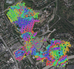
Colorized scans overlaid onto an aerial map of Louisville.
The solution in the rendering of the final subdivision plat included scale details of ground surface topographic contours and the relationship to different below-ground described elevations. The recorded plat is the only 3D underground survey plat ever to be filed at the Jefferson County clerk’s office.
Beyond the need for an accurate boundary survey, ALTA/NSPS Land Title Survey, and 3D minor subdivision plat, the data collected for the Louisville Mega Caverns has opened various other extended applications for Qk4 on this project. The existing lease areas within the climate-controlled storage building underground had been calculated decades ago by single baseline estimates because the non-uniform perimeters of the support pillars are difficult to measure by hand.
Now with a full scan of the interiors, actual floor plans can be produced, and the exact areas and even volumes can be documented for new clients. New development plans for new buildings referencing actual underground topographic features can be designed, including ingress-egress distances, roadway connections, and facilities for office and loading dock spaces.
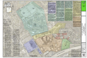
A portion of the ALTA/NSPS Land Title Survey with boundaries highlighted by legal description.
With a 3D digital archive of the Mega Caverns, no measurement needs to be estimated moving forward. The dataset has created new opportunities for both the owners of the space and for Qk4’s survey team as they analyze and extract information from the point cloud. The value of the survey on this project lies in the living and growing value for future use.
“We learned many lessons about the capability of our survey team and the methods and processes we use for all our projects,” Shinabery says. “Trust previous experience to help make sound decisions, don’t say ‘It can’t be done because it never has been done,’ and be willing to push the boundaries even if it takes you underground.”
Conclusion and Future Implications
The Louisville Mega Cavern project, realized through the pioneering efforts of Qk4, Inc., marks a significant milestone in land surveying, demonstrating the profound impact of integrating advanced technologies such as 3D scanning and mobile lidar. This endeavor not only showcases the capabilities of modern surveying techniques in complex environments but also gave experience and confidence for future projects.
The insights gained from this project illuminate a path forward for the surveying field, emphasizing the necessity of innovation and adaptability. It challenges us to rethink traditional methods and embrace new technologies, potentially revolutionizing how we understand and interact with the space around us.
As we move forward, let the Mega Caverns remind us of the boundless possibilities that lie in the convergence of curiosity and technological advancement. It’s a call to the surveying community to push beyond conventional boundaries and explore new horizons in our quest to map the future.
“Surveying the Louisville Mega Caverns was the most fun I’ve had working on a project. It presented many new challenges and opportunities to improve my skills and learn new techniques,” says Matt Jenne Qk4 survey technician. “Most surveyors would dream of working on a project like this.”
Ben Shinabery, PLS is the Land Survey Director at Qk4, Inc. and the NSPS Director for Kentucky. He is an early-adopter of technology for all types of land survey.