Tag Archives: laser scanning
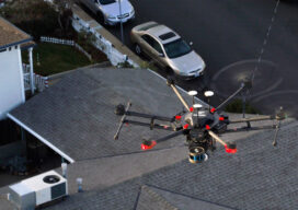
Walden Environmental Engineering Captures New Insights and Revenue
Emesent Hovermap was used by Harkin Aerial to conduct internal and external scans of assets for Walden Environmental Engineering. This resulted in simplified and streamlined projects with improved efficiency.
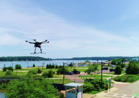
The Center for the Arts in Nevada County, California Optimizes Operations
Mobile LiDAR scanner Hovermap was used to conduct an internal and external scan of the facility in just over an hour to capture accurate as-builts and CAD drawings.
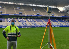
Laser Scanning Scores in Stadium Renovation
In Spain, soccer stadiums are often as beloved as their local teams. The Carlos Tartiere stadium in Oviedo, a small city in the northern Asturias region, is no exception. Built in 2001, the Tartiere stadium is home to the city’s Real Oviedo soccer team, a second-division club that’s been engaging fans for 95 years. As...

xyHt Weekly News Recap: 06/18/2021
Teledyne Launches New Bathymetric Lidar Solution Riegl Airborne Laser Scanner is a Leap Forward New Lidar System Delivers Long-Range Capability Northamptonshire Fire and Rescue Adopts GIS Software for Risk Analysis Robotic-based Solutions Enhance Curb and Gutter Paving Performance Toshiba Looks to Expand Solid-State LiDAR to Infrastructure Monitoring URISA Announces 2021 University Student and Young...

Everything you ever wanted to know about Mobile Mapping
Explaining the tools and technology behind mobile mapping devices for experienced laser scanning professionals looking to make the jump to this new technology. In its short life, the market for 3D as-built documentation technology has seen considerable innovation. Among the myriad new tools to hit this market, nothing has changed the way we capture buildings...
xyHt Weekly News Links: 06/26/2020
*Click here to visit xyHt’s Virtual Trade Show* SBG Systems has New Miniature Sensors for Navigation Microdrones Invites You to Play the Ultimate Surveying Game Show: SURVEYOR SAYS. Mobile Laser Scanning Technology Workshop Postponed ConTech Roadshows Rescheduled Monitoring and Protecting Ecosystems from Space China Launches Final Beidou Satellite; Completes GPS-like Nav System Ground Penetrating Radar...