Tag Archives: laser scanning

xyHt Weekly News Links: 04/24/2020
Data Analysis Recovers $2.27M in FSRM Funding at Air Force Base Teledyne Lumenera’s Lt Series USB3 cameras built around Sony’s finest sensors NASA has a video game to map coral reefs around the world Commercial UAV Expo Americas to take place as planned Sep 15-17, 2020 in Las Vegas Leica Geosystems and Geomap cooperate to...

Trimble in the Wild: Scanning the Roundest Bear
Katmai National Park broke new ground in laser scanning this October when a survey-grade scanner was used for their annual “Fat Bear Week.” Traditionally, the fatness of many a Katmai Park brown bear has been voted on by awe-struck online onlookers—the park has several webcams—and has been a matter of personal opinion gauged by eye....
Laser Scanning for GIS and FM
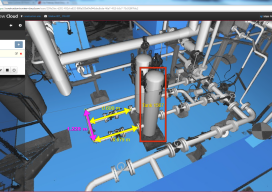
On the surface, rich laser- scan data seems like a natural, valuable addition to GIS and facility management (FM) solutions—and to related operations and maintenance and asset-management capabilities. Much as the emergence of GPS in the 1990s helped drive GIS adoption and growth, the emergence of laser scanning also feels ready to aid GIS, FM,...

No Job Is Too Big or Too Small
Alexandra Grounds, Founder & Director, Grounds Associates, Ltd. Editor’s note: In this year’s Outlook issue, we present trends in geospatial technologies and vision statements from key geospatial industry firms, but we also highlight smaller operations: the agile, tech-savvy, and talented practitioners and their teams. As the need for geospatial data and expertise grows, career paths...
The Value of 360º Digital Panoramic Images
The GeoDude tells us that rich, new deliverables are changing client expectations for the better. One of the biggest impacts that 3D laser scanning has had on the market is a set of new client deliverables that it has spawned. One deliverable in particular (360° panoramic digital images) has profoundly raised the bar of client expectations, yet...
The GeoDude on the Adoption of Laser Scanning Today
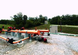
Part 2 Above: Although not yet fully mainstream for topographic surveys, laser scanning is frequently used to topo sites with a lot of detail and hardscape. Credit: Allegheny Surveys. With new and emerging technologies such as laser scanning, many professionals want to know “When is the right time to get in?” They may worry about...