
Explaining the tools and technology behind mobile mapping devices for experienced laser scanning professionals looking to make the jump to this new technology.
In its short life, the market for 3D as-built documentation technology has seen considerable innovation. Among the myriad new tools to hit this market, nothing has changed the way we capture buildings as much as mobile mapping devices.
For experienced laser scanning professionals looking to make the jump to mobile mapping, this article will provide all the answers. We’ll explain what a mobile mapper is, talk about how it’s different from a terrestrial laser scanner, and explore the technology that makes reality capture at a walking speed possible.
We’ll also explore the unique benefits of these tools for as-built documentation – with some hard numbers that quantify exactly how much these tools can help your projects – and then talk about the ways these benefits can transform your business and improve your competitive edge.
PART I: What is a mobile mapper?

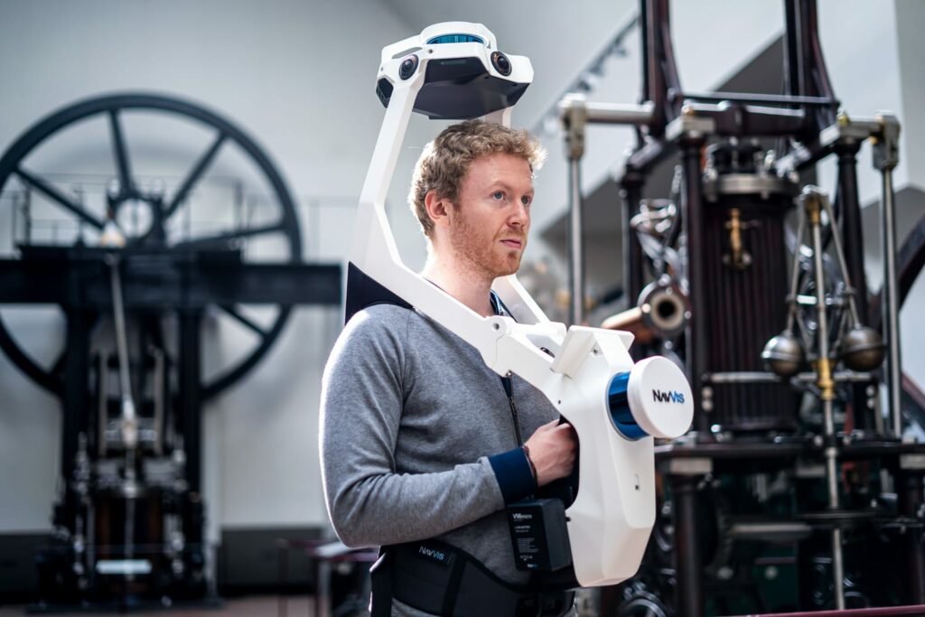
At its simplest level, a mobile mapping device is a laser scanner designed specifically for capturing buildings.
These systems combine a variety of sophisticated hardware sensors and software technologies to take the system off from the tripod, enabling you to capture accurate 3D data as you walk. By doing this, mobile mappers offer laser scanning professionals a faster, more flexible method for documenting large assets and complex environments like factories, work sites, or offices.
Compared to other laser scanning technologies, mobile mapping devices are relatively new, having hit the market only about a decade ago. Though early mobile mappers faced technological challenges that tended to degrade the quality of the data – causing justifiable reluctance about reliability for day-to-day survey work — mobile mapping devices have matured a great deal in recent years.
Today’s best mobile mappers can produce high-quality data suitable for a wide variety of tasks like Building Information Modeling (BIM) and floor plan generation.
The hardware
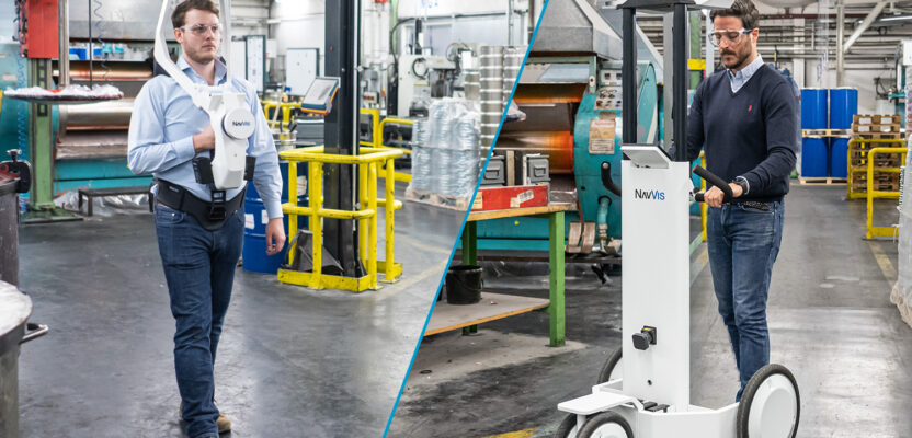
Mobile mapping devices can take a variety of form factors and sizes. On the market today, you’ll find trolley-based scanners that the operator pushes, portable scanners designed to be worn like a harness, all the way down to systems small enough to hold in your hand.
Regardless of shape and size, most mobile mappers have a similar payload of sensors. Generally, a system includes one or more lidar sensors. These sensors might be used for capturing point clouds or feeding the SLAM algorithm.
Each mobile mapping device also carries an inertial measurement unit (IMU), which the system uses to determine how it is positioned in 3D space. You can think of the IMU as a professional version of the accelerometer in your smartphone.
Most mobile systems also have one or more panoramic RGB cameras. The configuration of cameras on each scanner depends on the manufacturer, and the intended application of the scanner. A system optimized for generating digital twins, for instance, will often include more cameras, and capture at a higher resolution to produce more realistic looking 3D data sets.
The software
As you scan, these sensors generate a huge amount of data, which the system feeds to an on-board computer running a sophisticated processing algorithm. This algorithm, called simultaneous localization and mapping (SLAM), fuses the different kinds of sensor data to track your trajectory as you move and record the 3D map of the environment.
It’s worth noting that the SLAM algorithm is the most important difference between mobile mappers on the market today. Each manufacturer uses their own proprietary SLAM algorithm to process the huge amount of data generated by the sensors into a clean, final point cloud. And each approach this extremely complex task in a different way – meaning the differences in accuracy data quality can be quite large.
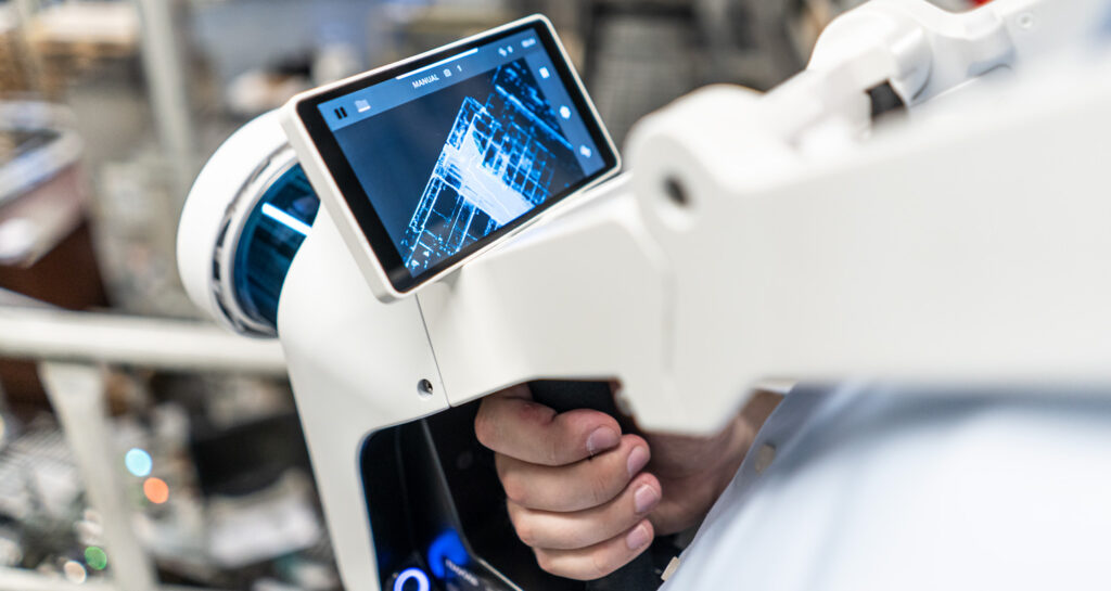
Virtually every mobile mapper includes a tablet interface. This tablet runs the software for controlling the mapping device, accessing and exporting previously recorded data, and performing certain processing steps.
The most valuable function of the tablet, however, is the real-time preview, which displays your mapping trajectory as you walk and gives you visual feedback on the progress of your scan.
Lastly, a mobile mapping system includes a dedicated desktop or browser-based application for final processing, management, and sharing of the scan data. These applications can be more or less powerful and functional, depending on the manufacturer.
PART II: Why mobile mappers are ideal for as-built documentation
Mobile mapping devices offer benefits across the as-built documentation workflow. In addition to streamlining the capture stage when you’re in the field, they offer a variety of features and functionality that can improve your workflow downstream.
Speed
Using a terrestrial laser scanner (TLS) to capture a building requires planning the scanner position, setting it up, and breaking it back down – repeatedly. Since you might repeat these steps dozens or hundreds of times while capturing a single building, the time saved by using a mobile mapper can be significant. In typical projects, we’ve seen mobile mapping devices offer a speed increase of 10X over terrestrial scanning.
Versatility
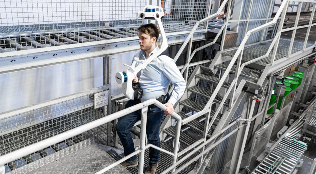
Mobile mappers can handle a wide variety of indoor environments, from large, open spaces like auditoriums and warehouses, to narrow spaces like mechanical, electrical, and plumbing (MEP) rooms, and multi-floor spaces with staircases. That means a mobile mapper can be the primary device for your building capture workflow – minimizing the time spent switching between different devices on the job site.
Feedback in the field
Most mobile mapping devices use the tablet interface to show your scan trajectory and give intuitive visual feedback about which areas have been scanned. If any areas were missed, for instance if part of a room was not captured due to an occlusion, this missing data will be clearly indicated on the display. Some tablet interfaces also feature advanced algorithms that can indicate the quality of the scan data you have captured, show the locations where panoramic images were taken, and even calculate the accuracy of the scan data using control points.

Less time spent on registration
A mobile scanner with hot-swappable batteries enables you to scan at a walking speed for more than an hour. That means you can capture a significant amount of the asset – in certain cases up to 3,000 square meters – before beginning another scan. As a result, a mobile mapping device can reduce the number of scans you capture and help limit the time you spend on the tedious step of organizing and lining up your scans in the post-processing stage.
Survey-grade results
Today’s mobile mappers don’t require you to sacrifice accuracy or data quality. NavVis VLX, for instance, uses advanced processing algorithms to produce low-noise, high-accuracy data suitable for typical as-built documentation needs, such as building information models (BIM) at LOD 300, or floor plans with a scale of up to 1:50. It also offers functionality for locking mobile scan data to surveyed control points to ensure the highest possible accuracy in challenging situations.
Easy integration with other capture methodologies
Though mobile mapping devices are designed to be extremely versatile for building capture, no device is suited for every application. For those rare times you need to use another capture method – for instance, when you deploy a UAV to capture the top of building – you can easily combine those data sets with your mobile scans. Simply use a familiar registration method like survey targets to quickly merge your scans for a complete data set that meets all project requirements.
Intuitive, photorealistic documentation
The best mobile mappers on the market include a payload of multiple panoramic RGB cameras. These sensors enable the mobile mappers to provide a densely colored, photorealistic 3D data set of the building that’s intuitive to navigate and explore, even for those who are totally unfamiliar with point clouds. These data sets can also be shared quickly and easily – enabling stakeholders like draftsmen, project managers, and other end-users to interact with their scanned building through any standard web browser.
By the numbers
To illustrate the benefits of a mobile mapper more concretely, we’ll show how these tools perform in a few typical as-built documentation projects.
Let’s say you are scanning a 1,000 sqm office that includes narrow corridors, staircases, multiple floors, and mechanical, electric, and plumbing (MEP) rooms. Using a tool like NavVis VLX wearable mobile mapper, you could finish the job in one hour and within one data set, with no need for further registration. In more open environments – like a garage – you could go even faster, capturing up to 3,000 sqm in an hour, and one data set.
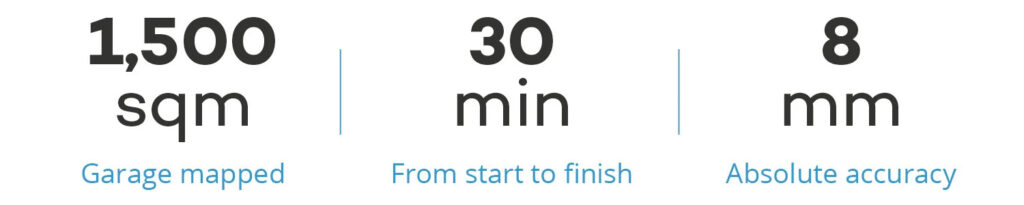
Crucially, this speed doesn’t come at the expense of accuracy. In one test project, we scanned a 1,500 sqm garage in 30 minutes. Without using our control point functionality to optimize the point cloud, we validated the final data set at an absolute accuracy of 8mm, well in line with the requirements of most as-built documentation projects.
PART III: Why it’s time to invest in mobile mapping
Mobile mappers will increase your scanning efficiency
Let’s say you’re set to perform a medium-to-large sized as-built documentation project – for example, a 5,000 sqm office building that includes a variety of spaces like staircases, small rooms, cubicles, long corridors, and mechanical, electrical, and plumbing (MEP) rooms.
In this scenario, investing in a mobile mapping system can speed up your project significantly. As we discussed previously, these devices are capable of capturing buildings at up to 10x faster than a TLS.
NavVis VLX, for example, can capture 1,000 sqm of complex office space per hour, meaning the project mentioned above would take about five hours of scan time to complete.
Additionally, where a TLS workflow can require two operators, a mobile workflow can be completed with only one operator. This enables you to free up valuable staffing resources to take on more projects.
Business benefit: Mobile mapping systems improve your scanning efficiency so you can finish big projects faster, and take on more projects, with your existing workforce.
Mobile mappers will reduce client disruption
Capturing an asset that is in active use, like a factory, hospital, office, construction site, or parking garage, can be especially complex.
These facilities present all the usual challenges for your as-built capture workflow, and one more: They offer very short windows of downtime for you to scan.
When you use a mobile scanner to capture an active site, the efficiency of the tool enables you to get in and get out much faster and reduce disruption to your client’s work.
Business benefit: Mobile mapping empowers your business to win more projects by bidding in industries where disruption is an issue, for instance healthcare, factories, and so on.
Mobile mappers will expand your services and offerings
Mobile mapping technology won’t just help you to gain new clients. It can also help you to offer new services and deliverables to your existing client base.
Right now, it’s likely that your usual deliverable for as-built documentation project is a CAD or BIM model. If you add an indoor mobile mapping system like NavVis VLX or NavVis M6 to your workflow, you can use NavVis IndoorViewer to automatically produce deliverables like fully immersive 360° walkthroughs for the site.
Deliverables like 360° walkthroughs can offer a great deal of value to your client.
The client can use them to help a variety of stakeholders explore and understand the building; to offer an easy interface for searching, adding, and viewing building information; or even to provide single source of truth for better collaboration in a wide variety of applications in manufacturing, construction, surveying, facilities management, and more.
Business benefit: Mobile mapping can improve your customer retention by enabling you to offer a more compelling set of deliverables than your competitors.
Mobile mappers will make your business more flexible
Adding a mobile mapper to your tool set means you can be more flexible about price when negotiating with clients.
Imagine you’re talking with a construction customer that wants to capture reliable as-is conditions for a potential refurbishment project in a relatively simple space.
Since construction firms often want to limit the expense for this kind of project, they won’t want to use a TLS (in fact, they will often send a student out with a disto to gather measurements by hand).
When you use a mobile mapping workflow, you can offer this customer the best of both worlds. You can supply a 3D deliverable that is much higher quality than they could get with a disto, and much more cost effective than using a TLS.
On top of that, you can configure your device to provide a different combination of speed and data quality. You could generate data at high accuracy for price A per sqm, and medium accuracy for price B per sqm.
You could let the customer pick the accuracy level that fits their needs, or mix and match accuracy levels for individual spaces throughout the asset.
Business benefit: Mobile mapping systems offer multiple levels of scanning efficiency, and multiple levels of data accuracy. This enables you to adapt your pricing and deliverables to the job requirements – and win more cost-sensitive clients.
Mobile mappers will sharpen your competitive edge
As we’ve covered already, mobile mapping technology empowers your business to scan more efficiently, reduce potential disruption for your clients, expand the range of deliverables you can produce, and offer more flexible pricing structures.
This brings an added benefit: It helps your business stand out from your competitors. If you use mobile scanners, you will differentiate your business during the project acquisition stage.
When the customer compares your business to a competitor that has a more conventional offering, your offer will look more compelling and you’ll be more likely to land the deal.
Business benefit: Using a cutting-edge (but tested) tool like a mobile mapping system will help you stand out from the competition, and win more customers, so your business can continue to grow.
Wrapping up
A mobile mapper is a laser scanner designed for building capture. It integrates a complex system of sophisticated hardware and software to enable the operator to scan as they walk—streamlining the capture workflow for offices, factories, and other facilities, while still providing 3D data that users can count on for survey tasks.
By taking the scanner off the tripod, mobile mappers offer several benefits that extend across the as-built documentation workflow – including faster speeds, greater versatility, reduced need for registration, and more. And they do it without sacrificing on the data quality or absolute accuracy your business needs.
This makes mobile mapping devices more than just tools for changing your project workflows. It makes them tools for accomplishing the long-term goals of your scanning business.
https://www.navvis.com/blog/explaining-the-tools-and-technology-behind-mobile-mapping-devices