Tag Archives: NOAA

NOAA’s New Geodetic Datum
Replacing NAD 83 and NAVD 88 have been in the works for a long time; now the change is getting near
The Responsibility to Map the U.S. Coastline
(And the Inevitability of New Geodetic and Tidal Datums) Since the arrival of the first pilgrims to the North American continent, there has been a need for precise knowledge of the coastline of the new country, and the reasons are obvious. Arrival by boat was the only alternative when crossing the Atlantic and escaping religious...

xyHt Weekly News Recap: 06/02/23
Seabed 2030 and NORBIT Oceans to Accelerate Global Ocean Mapping Phase One Launches iXM-SP150 Space-Hardened Camera at GEOINT CartoVista Unveils Latest in GIS Web Mapping Platforms USGIF Announces Three New Scholarships Sponsored by St. Louis Organizations NOAA Hires Woolpert for Hydrographic Survey, Bathymetric Data in Nome, Alaska Commercial Drone Alliance and Commercial UAV Expo Announce...
xyHt Weekly News Recap: 03/17/2023
Mach9 Launches New Geospatial Production Software for Global Infrastructure National Geodetic Survey to Present NGS DAY at FIG Working Week Become an Exhibitor and Sponsor at FIG Working Week 2023 Surveyors Exempt for New Universal License Recognition Law in Virginia Topcon Further Expands MC-X Platform for Compact Equipment Advisory Board Announced for Commercial UAV Expo...

Putting the Best Foot Forward
Surveyors’ Corner We are upon a solemn moment in the land surveying profession. Yes, we’ve all known for a while that this end-of-era moment was coming, but now it ends without pomp or circumstance, without the formality of an obituary, without even a memorial service. We bid adieu to a long-faithful companion that, for all...
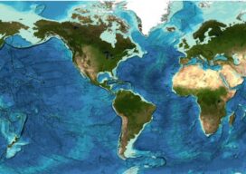
Staying Fluid: The Ocean Decade
More than 23 percent of the ocean seabed is now mapped Seabed 2030 is a partnership between the Nippon Foundation and the General Bathymetric Chart of the Oceans (GEBCO) and aims to map the entire planet’s seabed by 2030. To date, the project has mapped around 23.4 percent of the seabed. The latest data was...