Tag Archives: NOAA

Ocean Observation
Monitoring and comprehensive data collection is now a national security imperative For most of the second half of the last century there was general agreement that the primary existential threat to humanity was the purposeful or accidental exchange of nuclear weapons. While that threat has not been completely eliminated, in the 21st century there is...

Refining Measurement
A land surveyor unpacks the concept of accuracy “Accuracy is addictive,” my friend David Doyle once said. Doyle is a geodesist by trade. For someone in his line of work, this addiction has a rich tradition. Geodesy is the study of Earth’s shape, rotation, and gravity field. The discipline involves an eternal quest to refine...
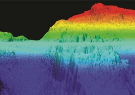
NOAA Advances Deep Channel Topobathy Lidar for Groundbreaking Alaska Project
Steep and rugged cliffs, rocky shores, changing turbidity, underwater hazards, and unpredictable weather are some of the extreme challenges of mapping the coastline and waters surrounding Alaska. However, a new topobathymetric lidar project for the National Oceanic and Atmospheric Administration (NOAA) conducted by NV5 Geospatial is leveraging a state-of-the-art combination of advanced remote sensing technologies...

xyHt Weekly News Recap: 02/18/2022
Riegl Instruments Used by Projects that Win MAPPS Geospatial Excellence Awards Geo Week Exceeds Expectations Trimble Introduces Catalyst GNSS LAND INFO Announces Updated 10m USA Countrywide Land Use Land Cover Mapping Dataset XMAP Cloud GIS Brings Government Flexible Working Closer to Home Sonardyne Launch Wireless Seabed Unexploded Ordnance Disposal Capability Fugro Joins UN Ocean Decade...
xyHt Weekly News Recap: 01/14/2022
GEOINT 2022 Innovative Tradecraft Competition Entries Open Jan. 12 MdGroup Acquires GeoCue Group Riverside Mfg. to Assemble Commercial GPS Receivers in the U.S Golden Software Facilitates Map Making and Data Export in Surfer Package Esri Book Demonstrates How Maps Enable Cross-Sector Civic Collaboration Hexagon and Dayou Partner to Bring High Accuracy GNSS Corrections to China...
xyHt Weekly News Recap: 10/01/2021
Hesai Announces Distribution Agreement with LiDAR USA Open Maps for Europe Releases First Datasets ISPRA Congress Set for June in Nice, France Pix4D 24-Hour Virtual User Conference Set for Oct. 6 UAS Summit & Expo Set for October 13-14 in Grand Forks HxGN Content Program Introduces Digital Twins of Major Cities NOAA Contracts for Coastal...