Tag Archives: NOAA

Seeing the Trees and the Forest
How airborne lidar and hyperspectral imaging helps improve America’s green space and, ultimately, our quality of life
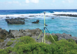
Island Hopping
Using topo-bathy lidar to map distant islands helps develop high-resolution 3D topographic data for the U.S. and its territories

xyHt Weekly News Recap: 02/19/2021
GNSS Receiver Keeps Around-the-World Yacht Race Winner in Position USGIF Accredits University of North Georgia New Trimble Total Stations Adds Versatility The Next Generation of Drone LiDAR MAPPS Awards Michael Baker International’s for Excellence NOAA Picks Woolpert to Collect Topo-Bathy Imagery NV5 Geospatial Unveils Cloud-based Data Management Platform
Radiant Earth
Connecting the global development community to Earth imagery and primary analytical tools. Nonprofits working on global development issues have had great difficulty acquiring and using a staple source of geospatial data in the form of Earth observation imagery collected by satellites. Anne Miglarese, the founder, and CEO of Radiant.Earth is working to change this. Miglarese...

Nicole Kinsman
Regional Advisor, National Geodetic Survey, NOAA/NOS Alaska, USA Alaska is a land of extremes, a land of both challenges and opportunities for the bold and adventurous. A combination of rapid plate tectonics, active volcanoes, glacial rebound, and remoteness makes mapping, surveying, and geodesy often extremely challenging. Nicole “Nic” Kinsman is the regional advisor for the...

Dealing with Vertical Datum, the Mariners’ Way
Before 3D GIS, we were able to measure miles below the sea and miles beyond our own atmosphere to a great level of accuracy, so how did we do it? There are a few methods for working between vertical coordinate systems, but the one I want to discuss is possibly the simplest, not always the...