Tag Archives: Ordnance Survey

Who are the “Geo6” and why will this change UK geospatial?
Around the middle of 2017, there was a mumble in the geospatial industry about how the UK government was going to open up more of its geospatial data. There was even an outrageous rumor that Ordnance Survey was going to have to release its multimillion-pound product, Mastermap. Everyone sniggered but watched the news like hawks....
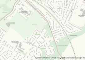
OS Zoomstack – the Gift that Keeps On Giving
On July 17 2018, Ordnance Survey (OS), the United Kingdom’s national mapping agency, released a trial of a product called “OS Zoomstack.” At the time many overlooked it, as Ordnance Survey makes lots of their data over 1:5000 available for free. I have to admit I was one of them. In August of last year,...
Improving GNSS in the Urban Canyon
To prepare you for the this blog post, I wish to point out that I am a geospatial expert and can hold my own around the ins and outs of survey, so going to an event at the Ordnance Survey on “3D mapping for the improvement of GNSS in urban areas” was an eye-opener. You...

xyHt News Links – 1/6/17
Cadcorp Ordnance Survey (OS) WMTS for systems integrators Viewpoint Construction Software® announces next gen collaboration platform uAvionix Announces FCC Approved Ping200S ADS-B/Mode S Transponder for Drones, Balloons, and Gliders Acuity Technologies Introduces New Lidar System Schonstedt Donates Equipment

Layla Gordon, Ordnance Survey Technology Laboratory Engineer
What is the Ordnance Survey Technology Laboratory? I managed to get an interview with one of the UK’s national mapping agency’s engineers, Layla Gordon, who has been working on some interesting geospatial tech. ND: How did your education lead you to OS (Ordnance Survey) and geospatial? LG: Back in 1994 I was doing a degree...
Charley Glynn
Cartographic Design Consultant at Ordnance Survey The art of cartography continues into the digital age. Dedicated practitioners of the art of map-making have bridged the transition from ink and paper to commercial and open-source mapping software. Certainly, maps need to convey data, but this needs to happen on multiple levels, and, despite the sometimes-cold digital...