
After two decades and a collaboration commonly valued at around a billion dollars, the United States has been mapped wall to wall in high-resolution lidar. The harder question begins now — what it costs to keep a national elevation model current, and who documents it well enough to trust.
XYHT STAFF
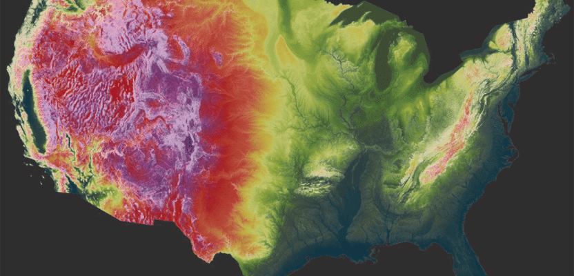
In a packed auditorium at Geo Week 2026 in Denver, the U.S. Geological Survey marked a milestone two decades in the making: baseline data acquisition for the 3D Elevation Program — 3DEP — is complete. For the first time, the entire United States has been mapped with consistent high-resolution lidar, with interferometric synthetic aperture radar (IfSAR) standing in for the cloud-shrouded terrain of Alaska. The result is a single, continuous national elevation surface in place of the patchwork of mismatched local datasets that came before it. USGS had been closing on the goal for years; by the end of fiscal year 2024, the agency reported 3DEP data available or in progress for 98.3 percent of the country. Denver was where it declared the baseline effectively finished.
For the surveyors, photogrammetrists, and mapping firms who make up much of this magazine’s readership, the announcement is not an abstract federal accomplishment. National lidar is the substrate beneath a large share of the profession’s daily output — the bare-earth model under a drainage study, the point cloud behind a corridor design, the elevation reference a floodplain analysis stands on. A great deal of that work was acquired, processed, and quality-controlled by private firms under contract. The basemap is a public asset, but it was built, tile by tile, by the same industry that now depends on it.
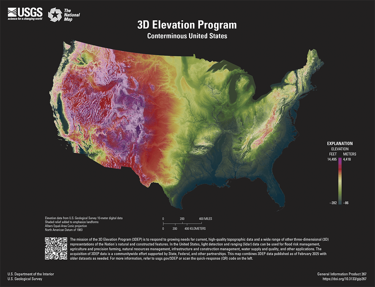
Credit: Jonesi, A.B., Thatcher, C.A., and Stoker, J.M., USGS, 2026 (General Information Product 267)
What “Complete” Actually Means
The baseline is defined less by a date than by a specification. 3DEP set out to cover the nation with Quality Level 2 (QL2) lidar — a minimum nominal pulse density and vertical accuracy sufficient for the bare-earth digital elevation models and three-dimensional point clouds that anchor most engineering and scientific use. “Complete,” in the program’s language, means consistent QL2-or-better data are available or in active acquisition nationwide, not that every county was flown to identical specification in the same year. Some areas carry far richer data; what is now uniform is the floor beneath them.
How that floor got built is as significant as the floor itself. 3DEP was never funded as a single federal flyover. It grew through a partnership model — a coalition of federal, state, local, and tribal agencies pooling requirements and dollars so that one acquisition could satisfy many users at once. USGS coordinates the effort through annual Data Collaboration Announcements, matching partner contributions against federal funds and acquiring the data through competitively awarded geospatial services contracts. That arrangement is why the program is commonly valued at around a billion dollars of cumulative public investment, and why so much of that investment flowed to private acquisition and processing firms. For the mapping industry, 3DEP has been both a national basemap and, for two decades, a substantial and recurring line of business.
From Snapshot to Refresh
The more consequential news out of Denver was not that the baseline is done but that USGS is already past it. The agency has finalized a new design for what it calls the next generation of 3DEP, and the central change is conceptual: the program is moving from a one-time national snapshot to a maintained, repeating time series. Under the next-generation model, USGS prioritizes reacquiring areas where the baseline data are five or more years old — eight years in Alaska, Hawaii, and the territories — or where significant landscape change has occurred. The questions shift accordingly. The baseline asked whether a place had been mapped at all. The next generation asks how recently, how often, and how much has moved since.
Quality is rising alongside frequency. Where no baseline data exist, USGS still anticipates QL2 acquisition, but the program now invites partners to collect higher-quality QL1-or-better data, with a clear financial line drawn: the federal contribution covers the cost of QL2, and any upgrade is borne by the requesting partner. That structure quietly reshapes the contracting conversation. The acquisition decision is no longer simply whether to fly, but to what specification, on what cycle, and paid for by whom. The economics the panelists at XPONENTIAL described at the project scale now operate at national scale.
The case for the spending is framed in benefit terms. The 3D Nation Elevation Requirements and Benefits Study, conducted jointly by NOAA and USGS and published in 2022, identified potential annual benefits on the order of $7.6 billion for the next generation of 3DEP, spanning flood-risk management, infrastructure, agriculture, energy, and critical-minerals work. A maintained elevation time series, in other words, is being justified not as a mapping product but as national infrastructure with a measurable return.
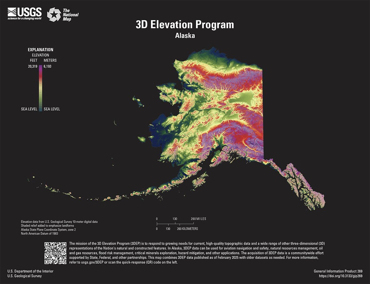
Credit: USGS 3D Elevation Program
Water Enters the Model
Elevation is only half of what USGS now intends to maintain. Running in parallel is the 3D Hydrography Program (3DHP), which is replacing the long-serving National Hydrography Dataset, the Watershed Boundary Dataset, and NHDPlus High Resolution with a new generation of surface-water data derived directly from 3DEP lidar. The agency describes it as the first systematic remapping of the nation’s hydrography since the original 1:24,000-scale topographic mapping program ran from 1947 to 1992 — a once-in-a-generation rebuild of where the country’s streams and watersheds actually are, this time anchored to a high-resolution elevation surface rather than to hand-compiled topographic sheets. The first 3DHP data have already published, in the Okanogan River area of Washington and the Birch Creek watershed in Alaska, with NHD-derived data migrating into the new framework as the remap proceeds.
Elevation and hydrography together form the 3D National Topography Model (3DNTM), the umbrella initiative introduced in the federal fiscal year 2023 budget that USGS now treats as its organizing goal. The agency’s framing has shifted from delivering fixed standard products toward sustaining what it calls a 3D Nation Ecosystem — a continuously refreshed, living model of the nation’s terrain and water rather than a dataset with a release date. Among the next generation’s stated aims is expanded interagency coordination on topobathymetric lidar for inland rivers, the green-laser technique that captures the streambed and the bank in a single pass — the same family of sensing that, at the coast, addresses the shoreline gap examined elsewhere in this issue.
What a Partner Actually Pays For
The federal-match structure behind that arrangement is more granular than a single billion-dollar headline suggests. USGS sets no fixed minimum or maximum for a Data Collaboration Announcement project; every partnership is negotiated as a percentage of project cost, scaled to what a given firm, county, or state can put in and to what USGS has left to obligate that year. Kevin Gallagher, the former USGS executive who helped build the partnership model, has described the payoff in blunt terms: for every federal dollar committed, the program has typically returned four to five partner dollars to match.
The next-generation cost split makes that arithmetic explicit at the project level. Where no baseline data exist, the federal contribution covers a Quality Level 2 acquisition; a partner that wants Quality Level 1 or better pays the difference itself. Hamilton County, Indiana, has worked that math directly: after acquiring QL1 lidar with a private contractor in 2024, the county returned through the fiscal year 2026 Data Collaboration Announcement to fund the elevation-derived hydrography that turns that lidar into 3DHP-compliant stream and watershed data — a two-part investment the county is treating as infrastructure rather than a one-time survey. For firms bidding this work, the practical upshot is that the federal floor is fixed and the ceiling is a client conversation: a contract scoped only to meet QL2 is a different proposal, at a different price, than one scoped to whatever higher-resolution standard a partner is willing to fund above it.
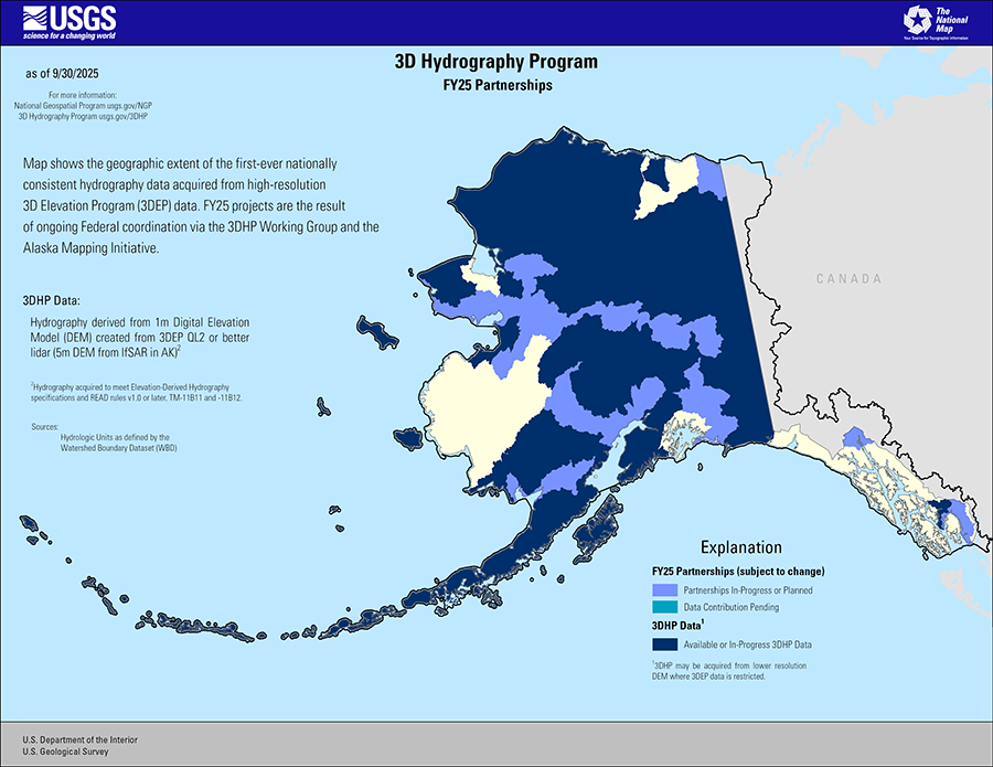
Credit: USGS
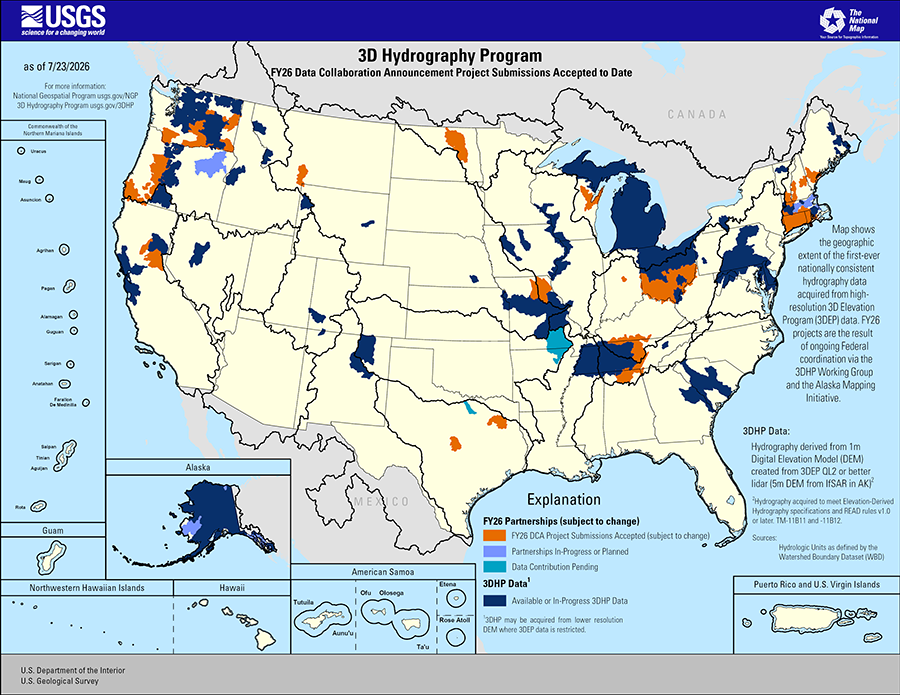
Credit: USGS 3D Hydrography Program
The Documentation Problem
A maintained time series solves one problem and creates another. The moment a national elevation model stops being a single snapshot and becomes a sequence of acquisitions at different dates, specifications, and quality levels, the value of any analysis depends on knowing precisely which version it rests on. A change-detection study comparing a 2018 QL2 surface against a 2025 QL1 reacquisition is measuring two things at once — real ground movement and the difference between two collection campaigns — and only documentation can separate them. The basemap’s currency is now a question every user has to ask, and the metadata that answers it is the part of the deliverable most easily lost.
That problem is about to compound. The modernization of the National Spatial Reference System — the rollout of NATRF2022 and NAPGD2022 to replace NAD 83 and NAVD 88 — will re-reference the horizontal and vertical framework that all of this elevation data is tied to. A national basemap assembled over two decades in the older datums will, for years, coexist with new work in the modernized frame. Reconciling those vintages, and documenting which datum, epoch, and quality level any given tile carries, is precisely the institutional knowledge that lives with the firm that did the acquisition — and precisely the knowledge that tends to walk out the door at project closeout. The firms that treat that documentation as a deliverable rather than as internal exhaust are the ones positioned for the maintenance era the baseline’s completion has opened.
The transition has a specific shape to track. NGS has been rolling out modernized components — GEOID2022, NAPGD2022, the new state plane coordinate system, SPCS2022 — for public testing on its beta site since 2024, with NATRF2022 scheduled to go before the Federal Geodetic Data Committee for a formal vote in February 2026. Once approved, the modernized frame becomes the official reference for the contiguous United States, and NAD 83 begins a managed retirement rather than a hard cutoff — legacy data does not vanish, but NGS tools and products default to the new datum going forward. For a firm holding two decades of 3DEP deliverables in the old frame, that vote is the date the reconciliation clock actually starts. It is the same vertical-datum problem examined at the coast elsewhere in this issue, applied here to dry land instead of a shoreline: a national elevation model, like a national shoreline, is only as trustworthy as the datum bookkeeping that travels with it.
USGS has been candid that finishing the baseline is not the end of the story but the start of a harder one. Mapping the country once was a generational feat of coordination and contracting. Keeping it mapped — current, consistent, integrated with water, and re-referenced into a modern datum — is a standing commitment, and one that runs through the same private firms that built the basemap in the first place. The substrate is finished. The work of maintaining it, and of documenting it well enough to trust, is just beginning.