Category Archives: Cartography
The Best Maps Are Not Behind Us
Professional cartographer Evan Applegate shares his mapmaking process, including what’s inside his toolbox. He also tells us why in-person feedback is important to become a better mapmaker.
The Still-Essential Skill of Cartography
Looking Forward When my kids were in high school, I made them learn to read a map. Their mother was incapable in this capacity, but still rode shotgun even though she had no ability to navigate us out of difficulty. When I got off course, I’d toss the map in the back seat and tell...

The Northern Hemisphere of the Celestial Globe (1515)
Maps as Art This whimsical map full of imaginary beasts and creatures is the oldest star map (or star chart) printed in Europe. It is based on the woodcuts by the great German painter Albrecht Dürer (1471-1528) who lived at a time when cartography was considered both as a work of art and a navigational...
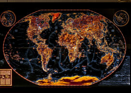
How Our Continent Drains
Robert Szucs is a digital cartographer turned artist who saw the potential to turn nature’s patterns into contemporary artwork. This ocean drainage map was a months-long project, that included “a ton of manual work,” including cleaning data, figuring out how to categorize millions of lines into a handful of ocean drainages, and then zooming in...
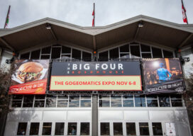
GoGeomatics Expo Puts Canada on the Geospatial Map
In the words of Will Cadell, “Geospatial is changing everything.” That was not only one of the opening lines of a visionary talk by Cadell, founder and CEO of geospatial consultancy Sparkgeo, it seemed to capture the sentiment of exhibitors, speakers and attendees at GoGeomatics’ inaugural conference. Held in Calgary, Alberta from Nov. 6 –...

Tracking the Paranormal
Mapping Your World Ever wonder where Bigfoot hangs out? What about where most UFOs fly by? Explore both with this per capita UFO and Bigfoot sightings map. The map by Kate Berg, which is featured in the 2023 GeoHipster calendar, cross references sightings of both by county. See what trends or patterns you glean from...