Multiple names and acronyms are used for this technology: UAS, UAV, and the sadly ubiquitous “drone.” The mapping industry avoids the military connotation of “drone” and prefers UAS (unmanned aerial system) to UAV (unmanned aerial vehicle). UAS encompasses the entire system: the unmanned aircraft and sensor package, the ground control system, the control link, a specialized datalink, and the associated mapping/imagery processing software. Most UAS are autonomously piloted (preferred for data collection), with remote control built in. Remote control can be used in the initial flight sequence as well as a back-up control method, allowing the ground-based pilot to take over control should he have safety concerns.
A high-level look at the state of UAS reveals four items of note: widespread UAS acquisition by firms that manufacture and sell geospatial technology, expanded platforms, increased sensor offerings, and needed legislation.
The list of geospatial tech firms that have either acquired, partnered with, or developed their own UAS offerings is a virtual “who’s who” of the industry: Altavian/Woolpert (Nova System), Leica Geosystems (Aibotix and Waran TC-1235), Maptek (DroneMetrex), Sanborn (Leptron Avenger and RDASS), Topcon (Topcon SIRIUS PRO/MAVinci), and Trimble (UX5 and X100). Even this abbreviated list points to widespread acceptance of this technology.
UAS fall into one of two classes: rotor-based (including helicopter and multi-rotor designs) and fixed-wing airframes. A third class seems to be emerging: fixed-wing vertical takeoff and landing (VTOL). Two U.S. firms, Latitude Engineering and Arcturus, are developing a new breed of hybrid VTOL UAS that take off vertically like a rotor-based UAS, then transition to fixed-wing flight and back for vertical landing. These are similar in function to the Bell Boeing V-22 Osprey.
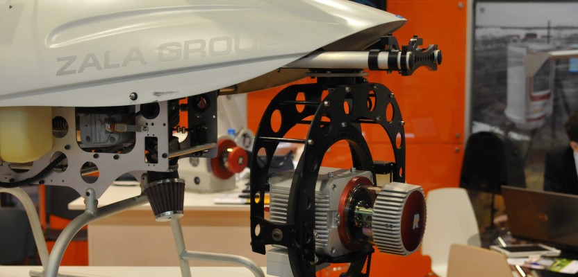
To date, commercially available UAS sensors have been almost universally camera-based, including infrared. This is changing with RIEGL’s VUX-1, the first survey-grade, lidar sensor purpose-built for UAS. Velodyne’s HD-32E, while not purpose-built for UAS, does offer a form and weight factor suitable for UAS platforms. Other lidar manufacturers will undoubtedly follow. Multispectral and hyperspectral cameras are hitting the UAS market as well. UAS manufacturer Draganfly has recently added the Tetracam ADC Micro multispectral camera as a sensor payload. Rikola and Headwall Photonics have both introduced hyperspectral cameras specifically for the UAS market.
The biggest factor in the future of UAS development and adoption in the United States will depend on the FAA. The FAA’s roadmap for UAS integration into U.S. airspace shows a date of September 30, 2015. However, in a February 2014 news update, the FAA disclosed that it “expects to publish a proposed rule for small UAS—under about 55 pounds—later this year.” In the near-term, this will most certainly drive development and adoption of UAS platforms towards this smaller class.
Aside from the “when” factor, the concern will be what exactly these new rules will entail. Two issues that will affect UAS adoption are whether the FAA will require UAS operators to be licensed pilots and how stringent their airworthiness certificates will be for UAS craft. The only certainty is that we will learn a great deal more on the subject of UAS incorporation into U.S. airspace in just a few more months.
Photo: RIEGL’s VUX-1 survey-grade lidar sensor mounted on a helicopter-style UAS, the ZALA 421-23.

