All posts by Gavin Schrock
Jackie Wong
Business Development Manager, Chain Technology Development Co. Hong Kong, China It’s sometimes hard to keep up with the evolution of AEC and infrastructure development—with so many new concepts and technologies. Even practitioners of the arts of surveying, mapping, and engineering must juggle learning new methods and machinations while assuring clients, partners, and stakeholders that all...
Rebecca Aguilar
Support Specialist, Topcon Positioning Systems California, USA Even the savviest users of the increasingly powerful geomatics/geospatial hardware and software sometimes need a helping hand. With great power can come great conundrums that, without excellent support resources, can be difficult to solve—especially with deadlines and spiraling costs on the line. Rebecca Aguilar has already proven to...
Justin Barton
Product Manager, Laser Scanning Systems, Leica Geosystems California, USA An early adopter and long-time practitioner of laser scanning, Justin Barton comes from an archeology background and spent nearly a decade with the world-renowned team of CyArk, a non-profit that creates digital records of sites and works of historic significance. Barton studied anthropology at UC Berkeley,...
Bronwyn Denton
Project Manager, AllTerra Land Surveying Ltd Kelowna, British Columbia, Canada While it is estimated that fewer than 10% of surveyors in British Columbia, Canada, are women, the numbers are rising, as is interest in the profession from young career seekers. This increase is reflected in more surveying lead and management positions for women in the...
Yan Fu, PhD
Principal Research Engineer, Autodesk – California, USA 3D, 3D modeling, 3D reality capture, 3D smart cities—these seem to be the zeitgeist of the present world of AEC and are touted as the path forward that will reap great benefits in engineering efficiencies. Managing and using enormous spatial datasets is a challenge, as anyone who has...
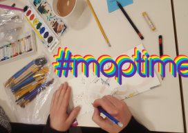
Maptime – Grassroots Geo-learning
From beginners to experts: #maptime chapters worldwide provide opportunities for cartographers, mappers, geospatial practitioners—and anyone with an interest in maps—to learn from each other. The concept and impetus behind #maptime are very simple: people who create (or have an affinity for) maps and mapping getting together to share common interests, tips, tricks, and techniques. If...