All posts by Nicholas Duggan FRGS Cgeog (GIS)
An interview with Mapillary CEO Jan Erik
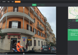
Following Mapillary’s announcement yesterday, I sought to get more information about Mapillary and how they have come to be such an interesting prospect in the geospatial world. Mapillary is a pioneer in new ways to capture, share, and utilize street-level images. Yesterday I had the privilege to interview Jan Erik Solem of Mapillary to get the...
Mapillary Raises $8 Million Series A to Democratize Maps by Connecting the World’s Photos
Technology has made the farthest corners of the planet more accessible than ever before. We can video call loved ones on the other side of the world; and we can view photos of foreign landmarks at the click of a button. At Mapillary, we are taking this accessibility to the next level by letting anyone...
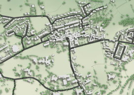
QGIS 2.5D Functionality
When I went into the office today, I had to write an amazing blog about the QGIS 2.5D functionality and how it was the beginning of QGIS’ journey into the 3rd dimension. Only I can’t, because Anita Graser, the author of “Learning QGIS 2.0” and owner of the Free and open source ramblings blog beat...
Web Mapping, Part 2
It’s as easy as 1, 2, built. In my last article in this series (December 2015), I briefly discuss the essence of what a web map is and the basic components. This part looks at the easy web mapping solutions that I briefly touch on in the last piece. I then discuss and provide the...
Web Mapping
Part 1, The Basics Children of the millennium will never know that there was a time before the internet when we, the cartographers, engineers, and surveyors had to relate geospatial information through the medium of paper. Although the internet has been around since the late 1980s, it wasn’t until 1996 when the world got the...

Why 3D GIS Is the Future
“The world we live in is a three-dimensional world, so why do we map it and analyse it in just two dimensions?” —Dragons8mycat, 2013 In the last five years, we, the GIS industry, have made some fantastic advances. So, why is it that we are so slow with the adoption of using 3D data? Surveyors...