All posts by Nicholas Duggan FRGS Cgeog (GIS)
Morphing Landscapes
Normally we create digital surface models (DSM) and elevation models (DEM) to analyze the topography and visual issues related to a project or issue. The requirement for accuracy and precision is paramount, ensuring that the correct method(s) of converting the data from raw source to an accurate model is more a work of art than...
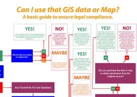
Can I Use That GIS Data or Map?
It’s no big secret, anyone can make maps. Esri even had some children showcasing their abilities at the user conference this year. So why employ a GIS specialist? Well, apart from getting the cartography right, the specialist can advise on the legalities of map & data production. With data becoming ever more available and online maps...
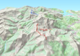
Create an Awesome 3D Map in Minutes in #QGIS
Until recently, 3D has been a bit of a gimmick to the everyday GIS user, by this I mean that it has been quite time consuming to create a GOOD 3D representation (easily) until now. I’ve used some great 3D software whilst working on survey data and also visualisation of environmental impacts, Fledermaus, ArcScene, Sketchup,...

Web Mapping for Dummies – My Personal Experience
Mapserver or Geoserver … that is the question Okay, let’s clear this up right from the start. If you are building a web map system, you are going to be looking at open source. Sure, there are other methods like Mapbox, CartoDB, QGIS Cloud, LizMaps and others but they mostly promise a free system for...