All posts by Nicholas Duggan FRGS Cgeog (GIS)
Further Adventures with 3D GIS
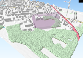
Last year I posted about this awesome plugin called “QGIS2Threejs” [here] and how it was possible to quickly render 3D visualisations for free using the open source GIS, QGIS. At the time I fudged some wind turbines as it was impossible to import models. Furthermore, I avoided too much detail as any imagery would look...
Recreating the Ordnance Survey Explorer Maps with Open Data
The holy grail for many (UK) map users is the Ordnance Survey 1:25,000 scale “Explorer” map. Not only are they easy to read due to the fantastic cartography used, but they also have information which is hard to source such as public rights of way, National Trust & Woodland Trust sites, even wind farms. To...
Why Your Maps Should Get in Touch with Their Feminine Side
Google does it, Apple does it, but do your maps use landmarks to improve users’ familiarity? More to the point, why aren’t popular landmarks a standard GIS dataset? For more than 10 years now we’ve known that the majority of the population use spatial recognition to navigate. When I say “majority.” I mean women and...

Quantum Navigation
Above: The Royal Navy submarine HMS Astute. Credit: LA(Phot) Paul Halliwell/MOD. Will freezing sub-atomic particles one day supplant GPS as the primary navigation technology? Many of the most accurate measurement devices, including atomic clocks, work by observing how atoms transfer between individual quantum states. The longer the atomic transition can be observed, the more precisely it...
GIS without GIS (Using Spreadsheets)
No, I haven’t gone mad, though some might disagree. I was inspired to write this after talking to a colleague who previously worked for a bank they were tasked with getting proximities to properties using Excel alone. This got me thinking over how much we crank up the GIS, when sometimes it is so much...
Top 5 Things to Do When You Install a New GIS Software
So, you’ve just downloaded the new QGIS release, latest ArcGIS, or maybe you are completely new to GIS and wondering how to even get started with this behemoth eating up your (or your employer’s) disk space. Having done this MANY times over the last 15 years of working with geospatial software, I’ve noticed that there...