
Blog

Market Opportunities for Geospatial in 2017
Construction Prospects, Part One As we start a new year, it seems only fitting to take a look at what 2017 might hold in store for us. Let’s start with construction: a major source of income for the geospatial profession. Dodge Data & Analytics publishes all types of data for the North American commercial and...
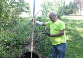
App Happy: Streaming Utility Surveys
A new app standardizes workflow by turning a list of surveyed points into underground 3D utility maps. Imagine that you’re surveying an underground waterline in your city. You use your survey devices to record the locations of the pipe system, including the manholes, the water valves, and their depths. Using your tablet on-site, you’re able...
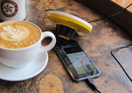
Trimble Catalyst — No Receiver Required*
*A groundbreaking new service turns your smartphone into a high-precision, software-defined GNSS receiver. The new Trimble Catalyst is a little hard to describe in terms we’re used to regarding high-precision GNSS. Is it a receiver? Is it a service? Do we really need only an external antenna, a subscription, and a smartphone? The answer is...

xyHt News Links – 1/6/17
Cadcorp Ordnance Survey (OS) WMTS for systems integrators Viewpoint Construction Software® announces next gen collaboration platform uAvionix Announces FCC Approved Ping200S ADS-B/Mode S Transponder for Drones, Balloons, and Gliders Acuity Technologies Introduces New Lidar System Schonstedt Donates Equipment
GIS Technology: Get It Surveyed
As I approach my 30th anniversary of being a licensed professional land surveyor in California, I can’t help but think about how things have changed over those years. One word: Technology. It has changed everything. For me, it started with EDMs, then total stations. Handheld calculators were emerging. When the HP 41-CX came out, that...
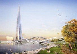
Sky Control: Lakhta is Russian Forward in Urban Development
Integrated geospatial solutions play a key part in building Europe’s tallest skyscraper. A new chapter in urban development is being written in Russia’s north-west corner. On the outskirts of Saint Petersburg, construction is underway on the new Lakhta Center, an ultra-modern facility that blends commerce, recreation, and cultural activities. In addition to incorporating hundreds of...
Advertisement