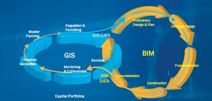
Above: Both Esri and Autodesk have shown this graphic at their individual presentations.
Will the Esri/Autodesk partnership take BIM head-on?
In August 2018, xyHt editor Gavin Schrock sat down with Jack Dangermond and Andrew Anagnost, of Esri and Autodesk respectively. They spoke of the natural industry links between the two companies and how they were planning to progress these links; we published the interview in the November 2018 issue.
A year later, where are we? I don’t see any new GeoBIM solutions, but maybe that is a good thing; just maybe they have been secretly beavering away at new innovations that are about to break. So I contacted a few of their people to see what was happening.
New Developments
Esri is quick to point out that the partnership hasn’t gone quiet; if anything it has only just begun. Already there is the collaborative tool, the Autodesk Connector for ArcGIS, that easily lets you bring your Esri data into InfraWorks, even updating your data with the mobile solution, Collector for ArcGIS.
Autodesk adds that users can connect GIS data in a more seamless manner to a 3D model in InfraWorks that can be used to begin designing using a BIM workflow in the earliest stages. With this capability, all attributes of the GIS data are added to the InfraWorks model, making the 3D context model much more intelligent, robust, and accurate.
The team is now working to deliver these capabilities in Autodesk Civil 3D, helping enable even more streamlined flow of GIS data throughout project workflows, from context modeling and conceptual design through detailed engineering.
Esri tells me how the workflows are also starting to appear in ArcGIS Pro now, too. Already there is the ability to consume Revit models, and there is a plan to improve this. Having looked at this, I have to say that they have done a fantastic job: all the data comes into ArcGIS Pro as you would expect with all the model attribution and BIM information you would expect. This is further enhanced by the new ability within the Esri software to slice through the 3D data.
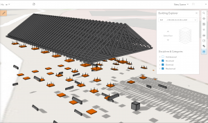
This screen shot is of revit model testing I’ve been doing.
So with the up-and-coming abilities to consume Esri data in Civil3D, will it work the other way, you may ask? Although there are no official emails or traceability, I can reliably say that I have had confirmation that consuming Civil3D data is on the Esri roadmap, and so is BIM 360 connectivity.
Autodesk does not have the same business model as Esri and does not put their roadmap or future plans upfront, and they stated that they were unable to share details of future deliverables. But, you can expect to see more connected workflows and product integrations from Autodesk and Esri as part of the collaboration. Is that a maybe?
Either way, from what we have seen so far things have moved forward.
Next?
Who would have thought that there would be a time when there was interoperability between Esri and Autodesk? Sure, we were able to consume dwgs and fbx files, and then there was the ArcGIS for AutoCAD tool, but this is a whole new level. It almost seems as if they are going to take BIM head-on and provide those final pieces of the puzzle that have been missing.
I leave you with this final word from Autodesk: “The two companies share a vision for putting GIS and BIM at the center of projects: driving smarter decisions, optimized designs, accelerated project approvals, reduced costs, smarter cities, and resilient infrastructure. We’re continuing to develop connected workflows for our shared customers, and there’s more to come!”
Special thanks to Karen Weiss and Chris Andrews for their input.