
Blog

An Interview with Ken Jennings
An Interview with Ken Jennings: Speaker, Author, Geographer

Wetlands Synergism
Professional interdependency is at the core of this project for acquiring federal conservation easements and restoring wetlands in Tennessee. Each item we touch these days has been shaped by a village of experts, from that cell phone in your pocket to the water coming out of the nearest drinking fountain. The surveying and engineering professions...

xyHt Links: 10/17/14
Juniper Systems’ New Rugged Handheld Offers Unparalleled Efficiency for Data-Intensive Applications NCTech ColourCloud Exelis adds night capability to CorvusEye wide area airborne surveillance system 3D Robotics Launches New 3DR Mapping Platforms for Fully Automated, All-in-One 2D and 3D Mapping Drone Packages SPAR Call for Papers Dewberry Selected for USGS National Assessment of Hydrography Data Routescene Presents...
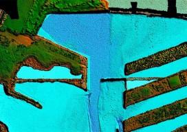
From Shore to Floor
Today’s technology records depth from land to deep waters accurately and efficiently. More than 90% of the world’s trade is carried by sea, according to the International Maritime Organization. Therefore, accurate and up-to-date charts of coastal waters for ship navigation are vital for world commerce. The current expansion of the Panama Canal, which will double...
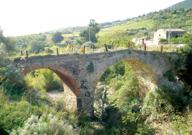
Sicilian Survey of the Norman Bridge
Standing at 10,970 feet tall, Italy’s Mount Etna dominates the eastern coast of Sicily and is the highest volcano on the European continent. At the foot of “the mountain,” as it is referred to by Sicilians, stretches a vast area of cultivated fields interlaced with a dense network of narrow streets bordered by the dry lava...
xyHt links: 10/10/2014
Better Resolution with More Details for 3D City Modeling Optech announces integrated airborne camera boresight and mobile INS drift control Mapbox and Pix4D partner up to allow one-click upload of orthomosaics Applanix Introduces New Solution for Cost-Effective and High-Accuracy Directly Georeferenced Mapping from Unmanned Aerial Vehicles RIEGL launches the RiCOPTER Unmanned Aerial System at Intergeo...
Advertisement