Standing at 10,970 feet tall, Italy’s Mount Etna dominates the eastern coast of Sicily and is the highest volcano on the European continent. At the foot of “the mountain,” as it is referred to by Sicilians, stretches a vast area of cultivated fields interlaced with a dense network of narrow streets bordered by the dry lava stone walls typical of the area.
West of the volcano, the area is crossed by the Simeto River as well as by distinctive “lava gorges.” These impressive canyons have walls 15- to 50-feet tall formed over the millennia as the river eroded the black basalt of Etna’s lava flows. The characteristic geometry of the basaltic prisms and how they show the interaction between sedimentary rocks and Etna’s volcanic lava make these gorges interesting from both landscape and geomorphologic points of view. In 2002, Simeto’s lava gorges were included in a list of valuable public interest locations as part of an effort to preserve the natural and semi-natural habitats and wild flora and fauna.
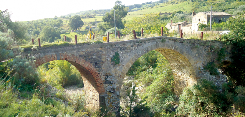
The land that the Simeto River crosses is also rich in history. It is dotted with numerous Roman, medieval, and modern artifacts, including the impressive Norman bridge over the Troina River. A tributary of the Simeto River, the Troina lies not far from the town of Bronte, known for its special pistachio trees.
This humpback bridge is a daring feat of medieval engineering, chromatically characterized by the alternating use of local basalt stones and white tuff, creating a two-color effect. It was built by Roger II (“the Norman”) in 1121, to connect the inland with the east coast of Sicily.
Today, unfortunately, the ancient bridge is in a state of disrepair. A project to restore the bridge was advanced by the Rotary Club Aetna North-West, who signed an agreement with the University of Catania calling for the renovation and restoration of the bridge and surrounding landscape.
The project needed a detailed scale model of the bridge. The survey work, commissioned to Tony Travagliante’s company STAID Srl, required a quick turnaround as the restoration project had to be delivered quickly and within a limited budget.
Overcoming Dense Vegetation
Just like with the Simeto, the basalt erosion by the Troina River over the centuries created an 80-foot deep canyon beneath the Norman bridge. Today the bridge sits in an area of dense vegetation, including reeds and shrubs that cover part of the bridge piles and abutments. A second, more modern bridge a short distance away provides a good view of one side of the medieval bridge and the underlying terrain.
The main goal of the survey was to create an accurate representation of the old bridge and surrounding area. Travagliante conducted the survey using a Trimble 5605 total station equipped with a Trimble-Geodimeter Control Unit and laser pointer. While a scanner could have easily handled the field measurements, the dense vegetation would have added significant time to office processing and modeling. In order to meet the time and budget constrictions, Travagliante decided to use the total station instead.
Creative Survey
Travagliante calculated that the survey would take two days to complete. With the help of an assistant and Sicily’s sunny May weather, Travagliante spent the first day carefully examining the site and deciding how to proceed. The second day was used to complete the survey operations.
Arriving on site, Travagliante and his assistant used the total station to establish a local network of five control points around the project perimeter. To do this they used a prism and two tripods (one for the instrument and one for the prism). They drove marking nails into the walkway of the Norman bridge and into the concrete curb and asphalt of the adjacent bridge. The nails allowed further resections and avoided unnecessary fixed stations that, given the general layout of the site, would have imposed very small viewing angles.
The survey proved to be more difficult than expected. Travagliante needed to measure several different types of points; some were easily accessible but many others were not. In order to collect the first points, the team needed to work on overgrown, uneven, and slippery terrain.
Once the instrument was in position, however, it was easier to acquire additional points. By changing the location of the total station, Travagliante could perform resections based on at least three reference points using a prism mounted on a telescopic pole.
The most difficult points to collect were on the sides of the bridge and the underlying terrain. In addition to the physical difficulty of reaching these points, the thick undergrowth left only a few points visible. Moving from one instrument station to another, Travagliante collected a series of points that followed the shape of the bridge arches and abutments. He also collected points on the terrain and in correspondence to the spikes of rocks. To collect ground data without walking through the difficult terrain, Travagliante used the Trimble 5605 direct reflex measurement to measure straight to the soil.
Once the control stations were established on the adjacent bridge, Travagliante faced a new challenge. The guardrail of the bridge was too high and blocked the instrument’s view, especially when aiming down towards the river. Reluctantly, Travagliante reset the height of the tripod and cautiously climbed up on the total station’s case to continue the survey on the edge of the bridge. (Don’t try this at home!)
The second day of work flew by. Travagliante met the delivery deadline and captured enough data to accurately describe the conditions of the area. He collected 1,382 points including control points, describing them through feature codes attached to each point.
Travagliante provided the Rotary Club with 3D points, creating planimetry, perspectives, and axonometry. The measurements allowed for the creation of a 3D model of the Norman bridge—the first step in the restoration of this important artifact.
Historical artifacts set within wild surroundings are a common feature in Sicily, as in all of Italy. It is difficult for any local administration to constantly check and prevent structures from falling into disrepair. The survey of the Norman bridge provided an accurate basis for planning needed restoration and requalification work. By using the Trimble 5605 total station, Travagliante could overcome the difficulties imposed by the bridge’s setting and surroundings to complete the work on schedule.
Photo: Undergrowth and steep slopes created challenges in measuring the bridge sides, piers, and abutments. Travagliante made good use of direct reflex measurements to capture difficult points.