
Blog
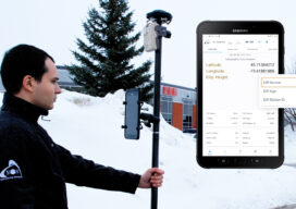
HAS Potential
Free and Global: The new high accuracy positioning service (HAS) of the Galileo constellation and its advantages for GIS and asset mapping If you consider field mapping applications, such as for GIS, asset inventory and management, and field operations for utilities, how wonderful would it be to have sub-foot positioning in real time, with no...

xyHt Weekly News Recap: 07/28/23
Cloudeo and Spire Global Team to Provide Space-based Weather Data USGIF Introduces 5 Community Leaders to its Advisory Committee. NOAA to Update the National Tidal Datum Epoch 250+ commercial UAS solutions providers slated to exhibit at Commercial UAV Expo GeoCue Unveils Three High-end Lidar, TrueView 3D Imaging Systems Sanborn Appoints Kate Hickey as Chief Operating...
xyHt Weekly News Recap: 07/21/23
Bad Elf Launches Flex® Mini High-Accuracy Bluetooth GNSS Receiver Collaborative Autonomous Drone Fleets for Next-level UAS Operations Trimble Dimensions: Last Chance to Register Early and Save USGIF Announces Six New Board Members For 2023-2024 Sanborn Employee Doug Browning Wins “MVP” at ESRI UC 2023 Where are They Now: The USGIF Intern Experience Topcon Introduces Aptix...
xyHt Weekly News Recap: 07/14/23
Bluesky’s Airborne Sensors Help Developers Protect Wildlife Habitats New Trimble Terra Office Workflow Delivers Integration with Esri ArcGIS Pro USGIF Announces Six New Board Members For 2023-2024 Topcon Introduces Aptix Integration Platform for Heavy Civil Construction Penn State Win Topographic Mapping at National Surveying Championship Tallest Mountain in Idaho is Higher Than Thought Registration Open...

Mapping Internet Deserts
North Carolina uses GIS to identify rural communities with poor broadband access to help farmers and fight poverty When Agriculture Secretary Tom Vilsack visited North Carolina last year to announce a $17.5 million grant for broadband connectivity, it felt like a lottery win for Warren County officials. Without the vital Internet connections that drive economic...

Low-Code/No-Code Mapping
Location-aware apps can now be created with almost no coding expertise. Is this the next frontier in mobile GIS? When authorities at the Ara Hīkoi Aotearoa, New Zealand’s Walking Access Commission, needed to revamp the country’s web-based maps, they knew that they had to build a handy and more user-friendly alternative for their hiking patrons. ...
Advertisement