Category Archives: Civil/Transportation

GEO Business 2017
Nicholas makes the annual pilgrimage to GEO Business for xyHt This blog is going to start with a short piece about skips. If you are afraid of skips (skips are what you’d call “dumpsters” across the Atlantic), turn away now …. Monday morning and 24 hrs from the start of GEO Business 2017, I get...

Markets for Geospatial 2017: Part 2, Infrastructure
President Trump’s plan for investing in America’s infrastructure calls for $1 trillion in spending over the next ten years. The specifics of the plan are still a work-in-progress, but with largely bipartisan support, chances are that there will be a big push on infrastructure projects in the coming years, and that should translate into significant...

DIY Immersive Virtual Reality
With Autodesk LIVE, you can build immersive virtual reality experiences for your clients, stakeholders, and your design team—yes, you. Drawings, renderings, physical models, 3D digital models, drive-throughs, fly-throughs, and walk-throughs–we’ve come a long way in being able to convey designs to clients and stakeholders, but also in communicating to our own teams as an essential...
Autodesk AEC Excellence Awards 2016 Winners Announced
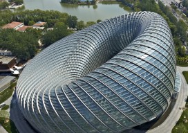
Autodesk AEC Excellence Awards Winners Embody the Future of Making Things for AEC Autodesk University Ceremony Honors Mortenson, BIAD, and Rambøll Sweco ANS with 1st Place for Construction, Building and Infrastructure Industries Respectively. By Jessica Brill, Autodesk At a special AEC Excellence Awards luncheon today co-sponsored by Autodesk and Hewlett-Packard at Autodesk University...
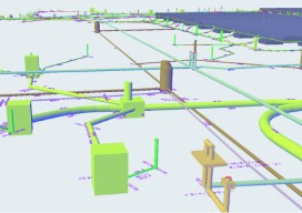
The Need for Civil BIM-level Objects
Alignment-based utilities are the key to BIM for civil engineering. It might sound odd to think that pipelines and conduit runs can play a key role in the evolution of BIM for civil engineering. In fact, you might wonder what I mean by “BIM for civil engineering.”BIM is a set of objects in a software...

UAS: It’s Unstoppable and Headed Your Way
From time to time I like to stop and think about the mission of Pangaea and explain that mission to you. My task is exposing you to new, emerging geospatial technologies. But why bother? Here’s a little analogy I thought of to help explain why keeping abreast of new geospatial tech is critical. Imagine emerging...