Using drones, lidar, and BIM, enterprising surveyors and geospatial engineers designed and constructed the city’s first high-speed train system.
Editor’s Note: Lessons learned from a problematic rail project in Mexico City prompted an initiative to pull out all technological stops for a subsequent new rail line. An innovative, tech-savvy firm that had demonstrated its capabilities on Mexico City’s new airport project was brought on board. Consorcio IUYET employed many of the newest technologies to tighten tolerances, to provide rigorously registered and quality-controlled 3D survey data, and to ensure fidelity between designed and constructed elements. This successful implementation of state-of-the-art surveying tech is impressive by any measure and reveals stark contrasts in results between legacy and modernized tech and methods.
Lessons Learned
In 2014, Mexico City’s Metro Line 12, called the “Golden Line” for its color representing the Mexican Revolution, was abruptly halted for fear the train would fall off the tracks.
“A new subway route was opening, and in just a few months it was closed. It seems the rails were not measured well and were damaged because they didn’t have the proper technology,” said Mexico City resident, Manuel Lino. “This happens a lot, and as a science journalist this has me very concerned.” Lino has reported on Mexico City’s science and technology topics.
He added, “Mexico City often uses technology at the lowest capacity. It’s like we have a plane, but we are using it to drive down the highway. We could fly but we don’t have the expertise to do this. Mexican engineers are quite famous for dealing with earthquakes, but I would like to see more of the latest technology that is available today being used in Mexico City’s transportation system.”
Lino’s dream has come true. The city’s first high-speed train is now available, designed and constructed using the latest geospatial technology. The project was initiated by the Mexican federal government in an ongoing effort to improve the growing city’s congested transportation system, reduce CO2 emissions from automobiles, and bolster the economy.

The Toluca-Mexico City commuter rail spans 36 miles as a multi-mobile transportation center.
Need for High Speed

Angelica Ortiz is Consorcio IUYET BIM director.
Consorcio IUYET was tapped to apply their geospatial-technology expertise to the project. It’s a leading Mexican civil engineering services company with 40 years of experience, including work on major infrastructure projects for Mexico City, including the Mexico City New International Airport.
“In order to prevent potential train accidents, it is so important that the right technology be used before you build a project,” said Angelica Ortiz, Consorcio IUYET BIM director.
The Toluca-Mexico City commuter rail is an electrified and elevated train system that spans 36 miles between Toluca in the state of Mexico and Mexico City.
“This train system is a multi-mobile transportation center that connects the whole city,” said Ortiz. “It provides people who work and live in Mexico City a faster, cleaner, and safer way of traveling to and from the city.”
The system consists of two main terminals (Zinacantepec station in Toluca and Observatory station in Mexico City) and four intermediate stations (Pino Suarez, Tecnologico, Lerma, and Santa Fe). There is also a tunnel that connects the adjacent state of Mexico with Mexico City. At the Tecnologico station riders can take a shuttle to the nearby Toluca International Airport, and at the Observatory Station in Mexico City riders can connect to the Mexico City metro system.
The high-speed train—with a maximum speed of 99 mph—can transport approximately 230,000 passengers daily to or from Mexico City in less than 40 minutes from end to end.
Ortiz said that providing efficient transportation between Toluca and Mexico City was needed. Many people live in Toluca and other metropolitan areas and work in Mexico City. Every day they commute to the western part where there is minimal public transportation, so, before the train, there was a mass migration of cars and busses going to and from the cities.
Ortiz said, “One time it took me one hour to get somewhere—that should have been a five-minute drive—because of traffic. It’s a big problem.”
Getting the Lay of the Land
Designing and constructing a high-speed train system that is safe and efficient, saves the government time and money, and is pleasing to the public required great precision. Consorcio IUYET used a wide range of geospatial technologies on every stage of this mega project, including unmanned aerial systems (UAS/drone), GNSS, a new rail inspection system, laser scanning, and building information modeling (BIM).
Ortiz said that in the beginning of the project the company collected 2D blueprints and plans from the client and analyzed them. They then visited the project site to establish a topographic reference network of control points. These control points were converted from Universal Transverse Mercator (UTM) to a topographic coordinate system so the data for the project could be used in accordance to Mexican standards.
“We made a data sheet for each of the control points including the UTM and topographic coordinates. These control points were used for all of the project phases from design, monitoring, and maintenance,” said Ortiz.
To ensure the network was extremely accurate, they used GNSS (Leica GS15) that can provide sub-centimeter precision.
Unmanned Aerial Systems
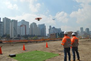
With a reference network established, additional information was collected using UAVs. Consorcio IUYET was the only company at the time in Mexico with a specific authorization for UAV operation, by the General Directorate of Civil Aeronautics. Ortiz said that drones were used from the beginning of the project. Their Leica/Aibotix hexacopters are an aerial platform over a meter across that can carry various payloads including a gimbaled high-definition DSLR camera. They flew them over the project site to look for inferences such as trees, utilities, and bridges and to collect high-definition images for photogrammetry.
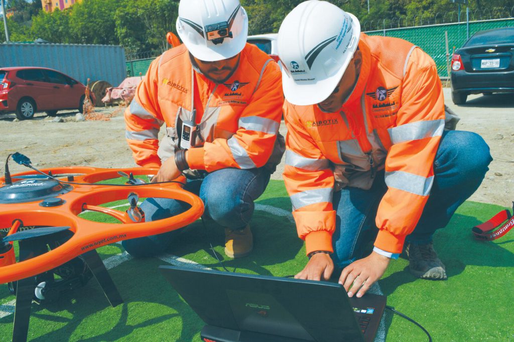
Consorcio IUYET’s Leica/Aibotix hexacopters performed inspections and documented the construction process.
During construction, they flew the drones over the site to perform daily or weekly inspections and to check on advances. “The drones can reach high elevated structures of the project that are unreachable and unsafe for construction workers,” said Ortiz.
Drones were also used to create 360-degree videos that provide a wide panoramic view of the building site. These videos can be from the ground level or from the air and can be static or in motion.
As the videos documented the construction process, Ortiz expects them to be useful to other countries that are interested in constructing their own high-speed train systems, such as England.
They also can be and are being used for promotional purposes. The British Broadcasting Corporation (BBC) is using Consorcio IUYET’s video as part of a documentary about train construction around the world.
“This documentary will display all of the technologies we used for the construction. To provide them video for their documentary, we sent up a drone and live transmitted from the air,” said Ortiz.
And most importantly, these videos were used to keep the client and decision-makers updated on the project. The company uploaded the videos to a private YouTube channel for their client’s use 24/7.
Ortiz said, “Sometimes Mexico’s government officials are in airplanes, and they check on the progress of the project right from their laptops while in flight.”
Laser Scanning
Drones were used from the beginning of the project with various payloads, including a DSLR camera.
Drones capture great views of a project, but greater 3D detail is also needed. This is where high-definition surveying comes in.
At the time, Consorcio IUYET was the only company in the world with an ISO 9001:2015 certification for a specific class of high-definition scanning (HDS, or 3D laser scanning).
Before the construction of the project, the company used HDS to create digital terrain models of the entire project site. These models provide a reality capture or 3D model of the actual terrain surface.
“To create this, over 2,000 static scans were performed collecting 1,000,000 points per second,” said Ortiz.
During construction, the company used a Leica ScanStation P40 to inspect structural elements of the project, such as the columns and beams that support the train tracks, for tolerances. Consorcio IUYET was the first company in Latin America to acquire this specific device.
These columns range between 14m-17m (46-55 feet) tall and weigh 127 metric tonnes (140 tons), and they support a standard-size track (about 1.4m or a little over 4.5 feet wide). They stand on uneven ground; there is a difference of approximately 1,000m (3,300 feet) in the altitude between the two cities.
This was an extremely important factor after a 7.1 magnitude earthquake rocked Mexico City in September of 2017. Ortiz said the scanning showed if the structure was affected by the earthquake and would be able to withstand another one.
“To do this we looked at the point clouds of the structure from before construction and after construction and compared them to see if there was any movement, cracks, or displacements in the structure,” said Ortiz. This wasn’t the only situation where HDS ensured the safety of the public.
The company was asked by the construction workers if they could perform lidar surveys in an area of the project that’s near Mexico’s City’s water system. Ortiz said, “They had an idea where the water system was located using their 2D capabilities, but they weren’t exactly sure where the system was passing by underground.”
Consorcio IUYET scanned the area using common control points and were able to position both underground scans (and GPR) and above-ground scans.
“What we discovered was that they were about to make a hole right where Mexico City’s main water system is located. We saved the government millions of dollars,” said Ortiz. If the company hadn’t been asked for their expertise, the government could have experienced another disaster like the “Golden Line” metro line situation (when many of the technologies used in the subsequent project were not used).
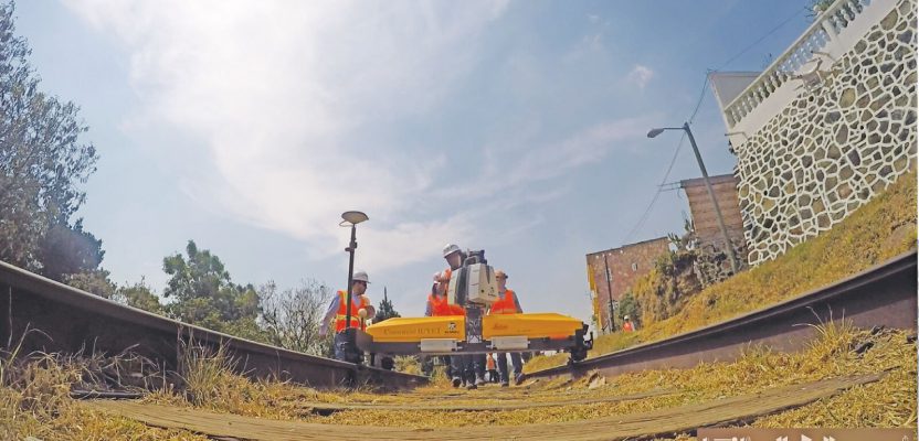
Problem prevention is also important once the project is completed. Consorcio IUYET is using the Leica SiTrack:One, a system that collects survey-grade point cloud data from a platform that runs on the rails, to maintain and monitor the completed project. At the time, Consorcio IUYET was the only company in the Americas that had implemented that specific solution. The SiTrack:One incorporates the Leica ScanStation P40 to generate 3D point clouds. It allows users to capture their complete rail environment.
Ortiz said, “You can walk with the SiTrack along the tracks, and it collects precise data of all of the rails. So, we can measure all of the wear and tear and compare point clouds to detect damages or changes in the structure.”
BIM
In order for the Consorcio IUYET team to make sense of all of the information they collected and to make decisions based on it, they fed all collected data into building information modeling.
BIM is becoming the standard for infrastructure projects. It is a management system for building, construction, heavy civil, and multi-discipled projects. BIM can be implemented for all project phases: planning, survey, design, construction, commissioning, and operations. The company’s BIM team included architects and engineers certified by Autodesk.
“Using BIM, we can create a virtual city where we can virtually construct the project. In this environment we have every element of the project—including each beam, column, foundation—with millimetric precision,” said Ortiz. She added that the BIM also includes all of the rebar and concrete, the information on the concrete providers, and where all of the materials come from.
“From this we can quantify the project. We can tell which parts are being built, which are in design already, and which parts are delayed,” said Ortiz
She said the core of BIM is for detecting interferences and that on this project several were found that saved the project time and money.
One primary example was the Mexico City water system discovery mentioned earlier. Ortiz said, “The workers were about to make a hole for a column right where the water system is located. With BIM we were able to locate the pipes and avoid a breakage in the system. Without BIM they would have punctured the main water system of Mexico City.”
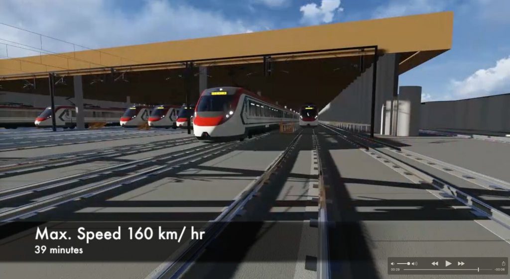
Mexico City’s first high-speed train (depicted here in a concept image) is now in use.
Educating the Public
Not only can BIM save clients’ time and money, but it can also help them to educate the public about the project, which helps the project move forward smoothly.
Local Residents
Tenants of an apartment building were complaining that the train system was going to obstruct their apartment views and bring down the value of their building.
Ortiz and her team visited the tenants and brought with them a BIM model. “We showed them a visualization of what they would see from their apartment. They watched the train moving along and going into a creek and not obstructing their view at all,” said Ortiz.
“We also positioned a camera on their building and on individual apartment windows and showed the tenants the views they would have after the train system was completely constructed. They were astonished and congratulated the government for the project and the technology used on the project,” said Ortiz.
Environmentalists
As part of the construction, the side of a mountain needed to be cut into in order to make space for several columns. As a result, thousands of trees would have to be removed, and environmental groups in Mexico City objected.
The company was presented with several proposals for dealing with this situation and created several different BIM models. Each model showed the Mexican federal government where the columns would be and what effect it would have on the trees.
Ortiz said, “From this, the government could get quantifications of the trees that were going to get removed or relocated while saving as many trees as possible.” This helped them to make decisions about the project.
Businesses
A university in the project site area had representatives complaining that a column was going to block the entrance of their campus and cause accidents. Ortiz and her team educated the representatives on how this wasn’t going to be the case. They showed them a virtual reality BIM model using a special headset so they could experience the project in a 3D world.
“They were able to move around the project and see how the column was not going to cause the university any problems, putting them as ease,” said Ortiz.
“Sometimes with photography you can only provide them a static view and they don’t see certain aspects of the project. Virtual reality BIM models provide them a 360-degree image. It immerses them into the model and they can realize and understand. We say an image is worth more than a thousand words.”
Merging Tech
If you’re considering using some of these geospatial technologies on a project, Consorcio IUYET has advice. Ortiz said that using one technology alone will not assure quality; it is their merging with experienced and trained personnel that can provide the best results.
“For example, say you are using a drone. This doesn’t guarantee quality information. You have faster information, but not quality information if you aren’t using the GNSS and don’t have a strong framework of control points. It is the combination and merging of these technologies that gives you a quality product,” said Ortiz.
The company encourages the use of more than one technology, but it must be done properly. Ortiz said to follow the regulations and standards and adapt them to your country.
She said one way that Consorcio UTYET is doing this is with BIM. The company is part of a group of public and private companies that are using BIM and are adapting the standards from the United Kingdom to the Mexican standards. She said, “For example, if we used imperial measurements when we get the plan, no one would be able to build because in Mexico we use meters and kilometers.”
For decades, Consorcio IUYET has been innovating the way technology is used in Latin America and helping its government to make Mexico City a better and safer place to live. The company looks forward to continuing this.
Ortiz said, “The future is to use this technology on projects to prevent problems—like the Golden Line situation—from happening again and to make Mexico City even better.
“We are looking forward to the future and maintaining this project. We know that Mexico is planning on expanding its train networks to provide a better transportation system. Building them and maintaining them is going to be a huge task. We are ready for it.”