Category Archives: Civil/Transportation
Grand Surveying in Grand Paris
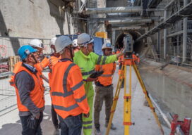
Advanced solutions for tunneling and monitoring keep Europe’s largest transportation expansion project on track All photos taken prior to introduction of COVID-19 distancing guidelines Paris is grand—and getting much grander. One of the most visited—and loved—cities in the world, The City of Light began the Grand Paris initiative in 2007 with the goal of keeping...

Doers: Christoph Hinte
Christoph Hinte on 25 years at Intergeo Christoph Hinte is the organizer of INTERGEO, the world’s biggest annual geospatial trade fair and conference. As CEO of HINTE Expo & Conference, he has been involved in the development and strategy of INTERGEO events since in 1995. Hinte tells xyHt why this year’s event, October 13 to...

The Early Days of 3D Scanning, Part 4: Chevron, Cyra and Trimble
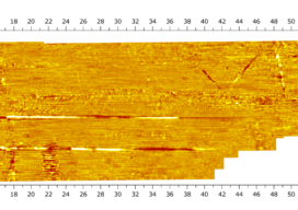
Thus far in my “insider story” (June, July, August 2020), I’ve described how, while working for Trimble in 1996, I first became aware of the technology, which was then still in development. After a jaw-dropping demo, I dove deep into evaluating the technology and its pioneering start-up company, Cyra Technologies, for a possible partnership with...
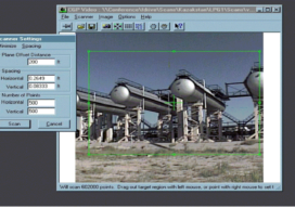
A New Dawn for 3D Ground Penetrating Radar Arrays
I was first immersed in ground penetrating radar (GPR) as a PhD student at Lulea University in northern Sweden in the mid-1990s, and I immediately fell in love with the technology. I love the ability it gives me to see hidden things so quickly and elegantly. I also love the notion that the equipment is...
The Early Days of 3D Scanning, Part 3: Cyra Unleashed
In Part 1, I described how in 1996, while working for Trimble, I first became aware of 3D laser scanning. It was being developed by Cyra Technologies Inc., a small start-up that had approached Trimble seeking a potential partnership. The jaw-dropping technology demo hooked my interest. In Part 2, I described my role in evaluating...
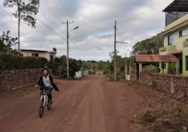
Galapagos in 360 Degrees
“Like cinders… infernal… leafless…” Charles Darwin wrote those words in his diary on September 16, 1835, after setting foot for the first time on the Galapagos. Darwin, whose scientific work in the far-flung archipelago considerably changed our understanding of how life on Earth evolves, was a keen observer of nature. And on that day, while...