Category Archives: Energy/Utilities
22 Young Geospatial Professionals to Watch in 2022 – 1 of 22
Throughout January, xyHt.com will feature the young geospatial professionals who are making a name for themselves in everything from surveying to geographic information systems. xyHt featured all of them in the January issue. Here we will spotlight one each day for the next 22 days. Name: Alfredo Eduardo Arzamendia Maldonado Company: Ministry of Public Works...
NSPS, Geospatial Firms and Others Support IIJA
In a letter to U.S. senators, the National Society of Professional Surveyors, geospatial firms, AEC firms, and transportation entities urged all senators to support the Infrastructure Investment and Jobs Act (IIJA), saying it will “provide meaningful economic and quality of life enhancements to communities across the country.” In all, 76 firms urged passage of the...
GNSS Innovation Keeps Utility Surveyors Safer
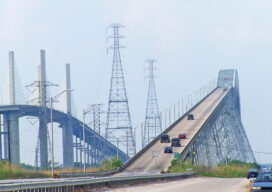
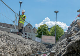
The ability to capture accurate points from a distance with images provides a significant leap in safety and efficiency for subsurface utility engineering.

xyHt Weekly News Recap: 07/16/2021
Esri Releases New Predictive 2050 Global Land Cover Map Esri Awards GIS Users for Innovations Velodyne Lidar Partners with NVIDIA Metropolis for Infrastructure Solutions Zoom75 & Zoom 95 – The New GeoMax Robotic Total Stations Lidar Helps Reveal Radiation Hot Spots at Chernobyl GIS-Pro 2021: October 3-6, 2021 Setting the Record Straight: The RETAIN Act...
The Early Days of 3D Laser Scanning: Part 11
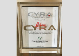
In 1998 I joined a small start-up, Cyra Technologies, which was pioneering 3D laser scanning technology. I had a senior product marketing role, reporting to the CEO.

Drones in Confinement
From warehouses to underground facilities, demand for drone inspections in GPS-denied places is rising. The new flying destination for UAVs is the great indoors.