Mobile lidar platform provides engineering firm with data sets for multiple deliverables
In the past, project teams couldn’t get high-quality, actionable data quickly when performing surveys—there was always a trade-off between time and quality. However, advances in mobile lidar technology are significantly reducing the time it takes to collect data while still meeting strict accuracy requirements and quality standards. Other advantages include improved safety for workers, easy integration with GIS, and comprehensive images and point clouds that support a range of applications, from 3D models to pavement management.
All About Infrastructure
Infrastructure design projects usually begin with a topographic CADD model that shows existing features, structures, and contours. Designers look at the current situation and determine the best approach to replace old construction or connect new structures to what is already there. Accurate surveys are critical to complex engineering projects, such as widening a roadway or adding a new interchange on a freeway.
Founded in 1968, Horrocks Engineers has grown from a small operation in Pleasant Grove, Utah to 19 offices across nine western states with more than 750 employees. With a focus on infrastructure, this civil engineering and professional services firm handles projects of varying complexity, scope, and size, and is committed to improving infrastructure, including roads, sewer and water lines, and fiber optics.
Topographic Mapping
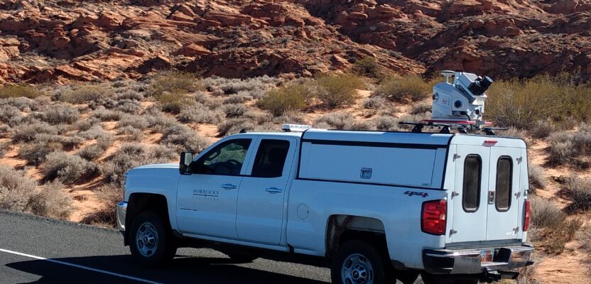
Horrocks uses Leica Pegasus: Two, a mobile platform that captures 360-degree images and lidar simultaneously. From the point cloud, all necessary features are extracted, such as curb and gutter, sidewalks, utilities, and contours, and the images provide additional visualization opportunities with color and detail.

A point cloud of city street in Mapleton, Utah, shows measurement of new sidewalk.
“We’ve been using lidar on design projects since about 2014, starting with terrestrial scanners on tripods and moving into mobile lidar in 2018,” says Derrick Sharp, GISP, GIS department manager at Horrocks. “A big benefit to us, our clients, and the communities we serve is the ability to quickly capture data in less time with mobile lidar as compared to traditional methods and a ground crew.”
A terrestrial survey on a 17-mile highway project would typically require us to shut down lanes of traffic, which inconveniences drivers and creates a big safety issue for our workers,” Sharp continues. “With mobile lidar, we drive the route in both directions several times at posted speeds and capture everything the scanner can see. If there are any questions, we refer to the point cloud instead of sending a crew back to the site. Much less time is spent in the field with little to no disruption to traffic—most of the work takes place in the office.”
In addition to being a slower process in the field, traditional surveying with a total station is done in a grid where a shot is taken every 10 or 20 feet to measure the contours. With lidar, whether it is on a tripod or the mobile platform, every millimeter of the surface is covered, which results in a much tighter contour DTM.
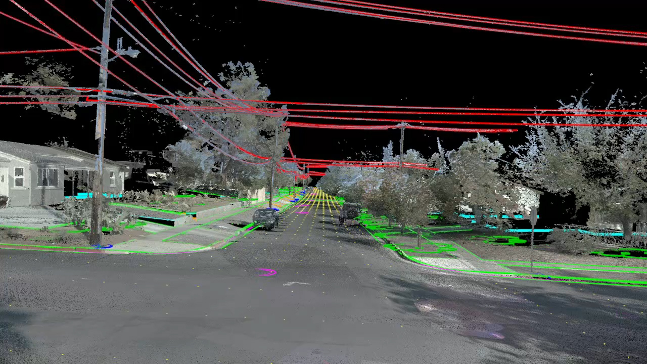
Features are extracted from the point cloud and used in other deliverables.
Typically for municipal clients, mobile survey deliverables include the images of an updated street view and the point cloud, which can be delivered in a variety of ways. Some clients want a scene layer package, while others request the files in a GIS-ready format or a POD file if they are using MicroStation. Horrocks works with the client to provide the deliverable that they want.
More Value from Topography
In addition to infrastructure design, topographic CADD models support other useful applications. Horrocks developed Informed Streets, a web-based software, to make the data more easily accessible for clients lacking the necessary tools or expertise to manipulate very large point cloud files.
Informed Streets is a platform that combines data in a 3D viewer from different sources, such as GIS, CADD drawings, point clouds, and photospheres. The user has access to all available data in one place, including design-level survey contours and the locations of manholes, fire hydrants, water valves, etc. In addition, using artificial intelligence (AI), an assessment tool evaluates the condition of the pavement and dynamically builds a pavement management plan based on the data collected in the field.
“We built Informed Streets to help our clients get more value from their data by viewing the point cloud in a web browser tied in with the rest of their GIS data and photospheres,” says Sharp. “For pavement maintenance, we apply AI to images to identify the type and severity of pavement cracking and calculate a Pavement Condition Index (PCI). The topographic data provides the exact location of each problem area.”
Previous records of pavement treatments combined with current conditions can be used to produce degradation curves and predict and explore future treatment options. The analysis removes subjectivity and is supported by quantifiable data, which assists with setting priorities and budgets.
Horrocks also developed the Construction Information Management System (CIMS), a customized project dashboard that consolidates construction processes and information. This web-based tool conveniently organizes drawings, design changes, specifications, inspection status, field tests, etc. for the use of contractors, project managers, and owners.
The accompanying mobile CIMS app expedites inspections and flags outstanding items in the field. The inspector completes forms and directly transmits information to the dashboard, which can help contractors receive payment in a timely manner.
“We try to leverage new technology, like mobile lidar, drones, and artificial intelligence to deliver better products across the board,” says Sharp. “Our customers benefit when we develop solutions that result in higher quality and efficient design and construction of infrastructure.”
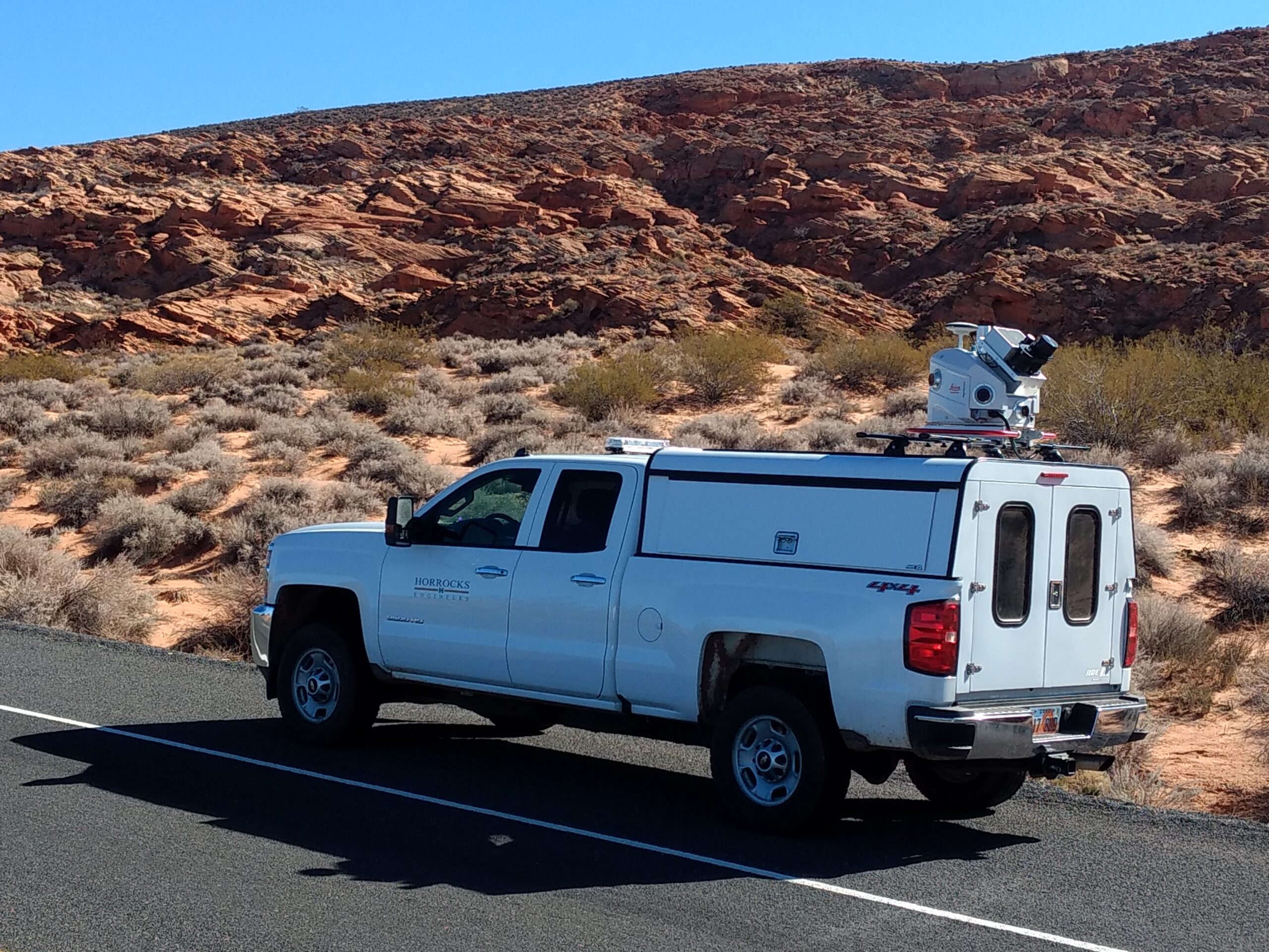
A truck-mounted mobile lidar unit expedites data collection for infrastructure projects.
Photography courtesy Horrocks Engineers