From Buzz to Shush
Fighting the drone of drones
Drones are hard workers. But because of the noise they make, many people are not fond of them.
In a recent survey in Europe, when people were asked about their main concerns regarding the prospect of drone services in their cities, respondents from six countries chose noise as their second top priority after safety. In a separate study conducted by NASA, people found the sound of flying drones “annoying” when compared to normal vehicles on the ground.
So while no one wants a loud worker on the job, it is surprising to know that UAV regulations around the world are silent when it comes to dealing with raucous drones. For example, the U.S. Federal Aviation Administration uses the same noise certification methods for both crewed aircrafts and drones, a practice that often leads to dissonance, especially since UAVs hover nearer to human communities than bigger planes. In the UK there is not even a noise standard for drones.
“As our skies become busier with UAVs, it is important to understand the noise impact they may have on the populations below them,” said Dr. Karthik Depuru Mohan, research fellow in Aeromechanical Systems at Cranfield University.
He is part of a team of researchers at the university conducting a study that aims to measure the noise produced by small- to medium-size multi-rotor UAVs at Cranfield’s global research airport. Results of these trials will improve the understanding of the impacts of drone noise levels and guide future regulations.
“A comprehensive study with a wider range of UAV types, flight paths, and maneuvers can help to establish UAV noise standards,” he added.
But another way to shush UAVs is to improve their design.
“If flying cars are to succeed, they’ll have to be quiet,” said Daniel Cuppoletti, assistant professor at the University of Cincinnati.
As the rotors of aerial vehicles spin, they move the air around them, creating that characteristic buzzing sound of drones. Changing the rotors’ design is a good start to reduce the noise, nipping the problem at its source. Cuppoletti and his students are now conducting experiments inside a specially-designed echo-free chamber, changing the design of rotors, and then measuring their noise signatures. Their aim is to create quieter drones.
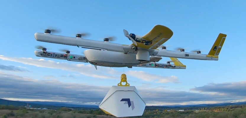
Drone manufacturers should make noise reduction a top priority if they plan to conquer urban air space. Take it from Wing, the drone start-up owned and operated by Google’s Alphabet. In 2019 the company was forced to re-design the rotor size of their drone delivery aircrafts after they received a spate of noise complaints from residents in Australia. They did so and now they are successfully thriving there, reaching their 100,000th delivery last year. Drones as a disruptive technology need not be a daily nuisance.
– Marc Delgado
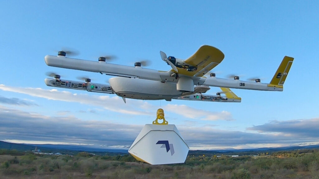
Photo Courtesy of Wing Aviation LLC
Make It Rain
Can UAVs solve the world’s water shortages?
Scientists are keen to expand the boundaries of drone use, including way up in the atmosphere. Since last year they have been testing how these winged machines can effectively wring out water from clouds.
In October, professor Eric Frew and his colleagues from the University of Colorado Boulder, flew fixed-wing drones to improve traditional rain-making operations.
Inducing rain can be tricky because atmospheric conditions continually change. But according to the team, their new approach “will help optimize the effectiveness and efficiency of cloud seeding programs” by targeting clouds in-situ.
To do this, the team used radar to identify locations in the sky for seeding. They then calculated an optimal flight plan toward the target cloud before flying out three UAVs. Upon reaching their destination, the two sensor-carrying drones measured real-time data to find the locations with the most suitable atmospheric conditions within the target cloud, while the third drone used this information to pinpoint where to exactly drop the seeding agents. The initial tests results have been positive.
Meanwhile, another group of scientists from the U.K. is also using drones to make rain, but in a different way.
Designed and manufactured at the University of Bath, the drones fly into low-hanging clouds, then zap them with an electric charge, causing cloud droplets to eventually build up and then fall from the sky as rain.
“We’ve done tests in the UK and demonstrated that we can release charge from the aircraft and detect it on the ground,” said Dr. Keri Nicoll who coordinated the research together with the University of Reading. “The next step is to repeat these tests in the U.A.E.”
The United Arab Emirates funded both the U.S. and British studies. Located in the Middle East, the country is eager to solve water scarcity through science and technology. In January, the country’s Program for Rain Enhancement Science said that it is strongly looking at the possibility of using drones for cloud seeding.
“Through harnessing new technology advances, the program plays a pivotal role in improving the effectiveness of cloud seeding and achieving global water security,” said Alya Al Mazroui, director of the program, in a press release.
– Marc Delgado
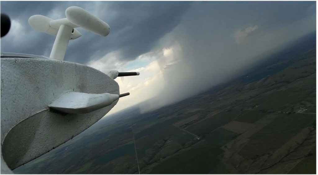
Photo Cred: NCM, UAEREP
Old Meets New
Modern technology on a 52-year-old aircraft still gets the job done
Technology in the geospatial professions has advanced so much in the last two decades that we think everything we use to solve modern problems is cutting edge. But after Hurricane Ida devastated a portion of Louisiana and parts of surrounding states last summer, the Sanborn Map Company called on a 52-year-old airplane for a mission.
On August 29, aircraft N940U was dispatched on an aerial survey mission out of Horn Lake, Mississippi, where Sanborn hangers the 1969 Turbo II Commander 680W. Piloted by Shelton Fisher, with a camera operated by Randy Jakus, the plane flew numerous missions collecting high-resolution aerial survey imagery in severely devastated parts of Louisiana to aid in response to the hurricane.
For N940U, it was just another series of missions in a long life of capturing data. The technology aboard N94OU may have changed over the last half-century, but the dependability of the plane has remained constant.
The aircraft got its certificate of air worthiness in April 1969, and still operates daily. Sanborn, of Colorado Springs, Colorado, purchased the plane in 2006. N940U is still flying thanks to its maintenance team of Ed Dent, Katie Heuermann, and Rodney Wingert of Sanborn with support from Ruben Correa of Aerofix Structural Services in Horn Lake.
Landing at airports damaged by the hurricane with no electricity, running water, or toilets, in over 100-degree heat, the airport ground and aircraft crew were able to refuel the plane to keep the mission going.
“Although the N940U is 50 years old, it is still a very stable and reliable aircraft that can navigate the thunderstorms and high winds for high-resolution imagery collection,” said Fisher, who also flew N940U in response to Hurricane Maria collecting data over Puerto Rico. He had to fly out of Punta Cana in the Dominican Republic due to the devastation at Puerto Rico’s San Juan Airport.
The aircraft was built by the North American Rockwell Corporation and is one of a fleet of 12 aircraft operated by Sanborn, which provides state-of-the-art mapping, visualization, Web GIS, and 3D solutions to customers around the world.
Hopefully there are many more missions in its future.
– Jeff Thoreson
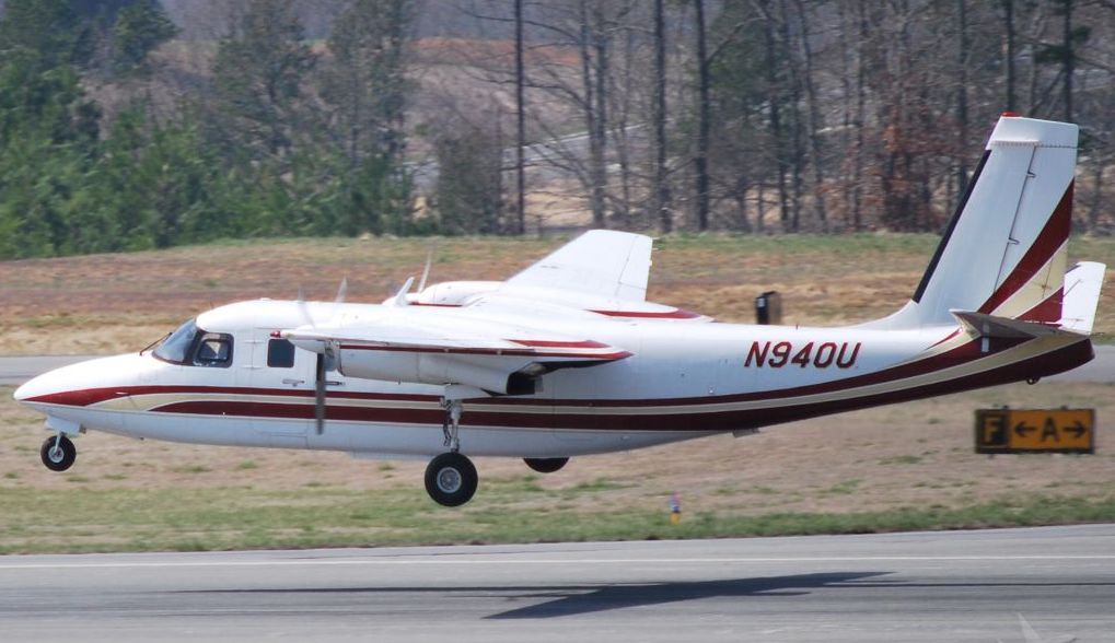
Sanborn Mapping’s reliable 52-year-old Turbo II Commander 680W.
Tracking UAVs
FAA updates its Remote ID rules
As part of the FAA’s effort to fully integrate drones into the National Airspace System (NAS) it is implementing Remote ID, which helps the FAA, law enforcement, and other federal agencies find the control station (operator) when a UAV appears to be flying in an unsafe manner or in an area where it is restricted from operating.
On the technical side, Remote ID requires all UAVs (except for those flying in a FAA-recognized identification area aka FRIA) to broadcast the craft’s unique identifier along with a host of other identifiers, specifically geo-data on the UAV and its control/launch location.
The FAA’s Notice of Proposed Rulemaking (NPRM) on Remote Identification of Unmanned Aircraft Systems was published on December 31, 2019. At that time, many were alarmed at what they saw. Now the final rule has rolled out and UAV operators must comply with Remote ID starting September 16, 2023. UAV manufacturers must comply with the final rule’s requirements by September 16, 2022.
Fortunately, many of the more onerous rules were modified.
Privacy: in the original NPRM, law enforcement and the general public would have been able to use an app to track the location of a drone and its operator(s). Logically this would include drone-haters. Using the app, folks who can’t stand drones could, under the old NPRM, locate the operator and cause issues ranging from annoying interruptions to assaults. The new rule states: “Authorized individuals from public safety organizations may request identity of the drone’s owner from the FAA.”
Costs: Another concern was what happens to the many legacy “pre-Remote ID” UAVs. Owner/operators of legacy UAVs were wondering about the cost of retrofitting existing UAVs to meet the new requirements.
In the original NPRM, the FAA did not want to see “add-on” solutions, it was campaigning for only built-in solutions that would be harder for end users to circumvent and doubtless more expensive to retrofit. Fortunately, that has changed in the final rule. Now it is accepting “Remote ID capability through a module attached to drone.”
Just recently a Czech startup, Dronetag, has released Dronetag Mini, Remote ID unit that can easily be attached to existing drones to meet the FAA Remote ID rules by broadcasting in Wi-Fi and Bluetooth. The unit is a small (2.1 x 1.3 x 0.6 inches), lightweight (1.1 ounce), and retails for $285. This gives us a peek at what future modules might look like and cost.
So, the FAA’s final rule on Remote ID does offer some good news and avoids some of the most objectionable factors that were raising such concern in the original NPRM. Big sigh of relief for many UAV operators.
– Jeff Salmon
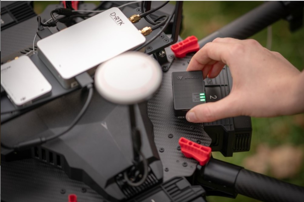
Czech startup Dronetag has created a small Remote ID unit that can easily be attached to existing drones to meet the FAA regulations. Photo Cred: Dronetag
A Battery Breakthrough
Lifting drones with the lightest element in the universe
Elon Musk might not be a fan calling them “fool cells,” but there is no doubt that a new generation of batteries have already entered the mainstream: hydrogen fuel cells.
During this year’s CES, the world’s most important consumer tech event, not only trucks, sedans, and SUVs were spotted with hydrogen-powered batteries under their hoods. Drones have also joined the latest revolution in battery technology.
Winner of the CES Innovation Award is the DJ25, the world’s first VTOL (Vertical Take Off and Landing) commercial drone. Powered by hydrogen fuel cells, this zero-emissions and quiet aircraft can fly for five hours over a maximum range of 500 kilometers, all this while carrying a four-kilogram (8.8 pound) payload. Current UAVs in the market that can match the DJ25 are usually powered by gasoline.
Another CES award winner is a complete UAV solution that combines artificial intelligence technology for solar energy infrastructure inspections. Thanks to its hydrogen fuel cell, the drone can fly for a solid two hours compared to the industry standard of 30 minutes.
The lightest element in the universe has surely impressed the judges at CES.
“The potential of hydrogen fuel cell drone technology that delivers the endurance and performance necessary to enable autonomous UAV flight, without carbon emissions, is huge,” said Soonsuk (Fran) Roh, manager at Doosan Mobility Innovation, maker of the two award-winning drones.
Such innovation comes at the right time after the FAA has approved drone flights beyond visual line of sight (BVLOS) last year. Drones operating at BVLOS can surely do more with powerful batteries. Two U.S.-based drone companies, Iris Automation and Drone America, have recognized this and are partnering with Doosan to boost their BVLOS capabilities.
“Getting to higher density, zero-emissions fuel is an important breakthrough for long-range drone operations,” said Lori DeMatteis, vice president at Iris Automation. “This makes commercial operations increasingly viable and cost-effective.”
– Marc Delgado
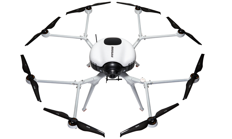
Photo Cred: Doosan Mobility Innovation
Intelligence and Security
Wide-area aerial camera helps recon and security missions
Let’s start by explaining the three-letter acronyms: ISR stands for intelligence, surveillance, and reconnaissance; SAR, in this case, stands for search and rescue. Wide-area aerial cameras are great for conventional mapping as well as ISR and SAR applications thanks to their ability to capture data from wide swaths of territory rapidly and accurately.
Phase One’s new iXM-GS120 aerial camera is a prime example. The unit’s single-sensor design, along with its 120MP resolution, ensures fast collection of detailed information over a wide area of interest in every frame, thus reducing flight times and boosting effectiveness and efficiency. On the processing side, this single-sensor design also eliminates the time-consuming stitching together of image scenes from multi-sensor camera systems.
The iXM-GS120 is multi-platform capable and can be used on group 3 UAVs, helicopters, and fixed-wing craft. The new camera integrates a CMOS global shutter sensor, with a superior seven-frame-per-second capture rate and broad dynamic range. This technology gives the camera the ability to collect data in low-light conditions, thereby expanding its operating window by several hours per day. This is a critical factor for time sensitive ISR and SAR missions where every minute counts and a welcome feature for maximizing the efficiency of mapping missions.
Adding to the unit’s versatility, the iXM-GS120 is available in RGB color and monochrome versions. The camera’s range of applications is further broadened by an expansive selection of fields of view for operation at numerous different aircraft altitudes and speeds. Compatible fields of view include a range of lenses from 35mm to 300mm.
– Jeff Salmon
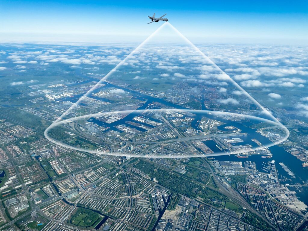
Photo Cred: Phase One Geospatial
Mapping a Landslide
UAVs help Georgia assess and monitor landslide
A fissure opened on a hillside above a road connecting the Tbilisi suburbs of Vashlijvri and Nutsubidze, creating a landslide in the Georgian capital.
When the fissure opened in March 2021, local authorities had no awareness of the stability of the terrain or an initial record of the size of the fissure. They needed to analyze and measure the crack as well as evaluate its likeliness to move. They also required a comprehensive view that did not create unnecessary risk.
To meet these challenges, the National Environmental Agency of Georgia used a senseFly eBee X UAV and PIX4Dmapper photogrammetric processing software, in collaboration with Tbilisi City Hall, to measure the area. UAVs are excellent tools for providing situational awareness of disasters of all kinds.
The eBee X is a fixed-wing UAV that made it particularly suitable for this mission. The UAV has a flight time of up to 90 minutes, which translates into fewer flights per mission and thus enhanced operational efficiency. The eBee X is available with RTK/PPK to maximize accuracy and reduce mission times since no ground control points (GCPs) are required.
Georgian authorities utilized the RTK/PPK-capable eBee X and employed RTK to ensure geolocational accuracy. Operations involved two flights to evaluate movement as well as measure the volume of land being displaced. The area of interest totaled 500,000 cubic meters across 2.5 square kilometers and comprised more than 800 images across these flights, which were imported into PIX4Dmapper for post-processing into a Digital Surface Model (DSM).
Factors examined included: depth, volume, curvature of the fissure, potential movement of the landslide, predicted velocity, and flow accumulation.
Using this data, the government was able to precisely install measures to stabilize the landslide. Using a drone to tackle this project provided a safe, effective, and accurate method of dealing with the geophysical hazard.
– Jeff Salmon
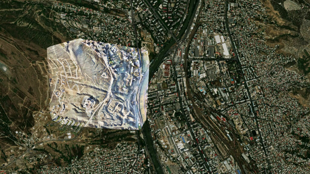
The area that was mapped shows how close to the Tbilisi city the landslide occurred. Photo Cred: Pix4D/senseFly