Category Archives: Enviro/Ag

Disparate Data for Marine Life
Remote sensing data helps to inform ocean planning for energy development around the main Hawaiian islands. Using remotely sensed imagery to map physical and biological patterns in the marine environment enhances our ability to understand how environmental conditions change over broad spatial scales (10s to 100s of kilometers) and temporal scales (years to decades). These...

Mars Colonization: Mars Need Surveyors, Part Two
This is Part 2 of our Mars Needs Surveyors series from the Pangaea newsletter. Part 1 is here. As the dream of Mars colonization comes to fruition, what would surveyors be tasked with? Habitat construction SpaceX’s Elon Musk’s vision is to build a city on Mars (appropriately named SpaceX City) that would eventually be inhabited...
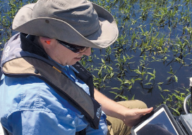
Fluid Data: GNSS and iPads
Lawrence Spencer puts the Trimble R1 GNSS receiver and iPad to work on the Kissimmee River. Pairing GNSS with iPads opens seamless data flows for a water management district in Florida facing wetlands complexity. Lawrence Spencer first joined the South Florida Water Management District’s (SFWMD) lake and river ecosystems section in 2006 as a...
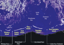
Crossing the Barrier
Above: The Barrier Islands off the Gulf Coast are threatened by coastal land loss. A Louisiana university overcame a barrier facing scientific research of coastal land loss—with a UAS. “We are losing an acre of coastline every 30 minutes,” says Dr. Gary LaFleur Jr., associate professor of biological sciences at Nicholls State University in Louisiana. And...

UAS: It’s Unstoppable and Headed Your Way
From time to time I like to stop and think about the mission of Pangaea and explain that mission to you. My task is exposing you to new, emerging geospatial technologies. But why bother? Here’s a little analogy I thought of to help explain why keeping abreast of new geospatial tech is critical. Imagine emerging...
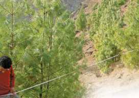
A Crowning Achievement in Nepal
An ICIMOD team manually validated the accuracy of the 2011 classification maps. Pairing satellite imagery with advanced object-based image analysis helps people in Nepal better manage vital resources. For decades, the high-mountain regions of Nepal have been caught in a perpetual catch-22. The small populations of these remote, isolated areas depend nearly exclusively on local...