Pairing GNSS with iPads opens seamless data flows for a water management district in Florida facing wetlands complexity.
Lawrence Spencer first joined the South Florida Water Management District’s (SFWMD) lake and river ecosystems section in 2006 as a staff environmental scientist. An equally apt title could have been staff paper shredder.
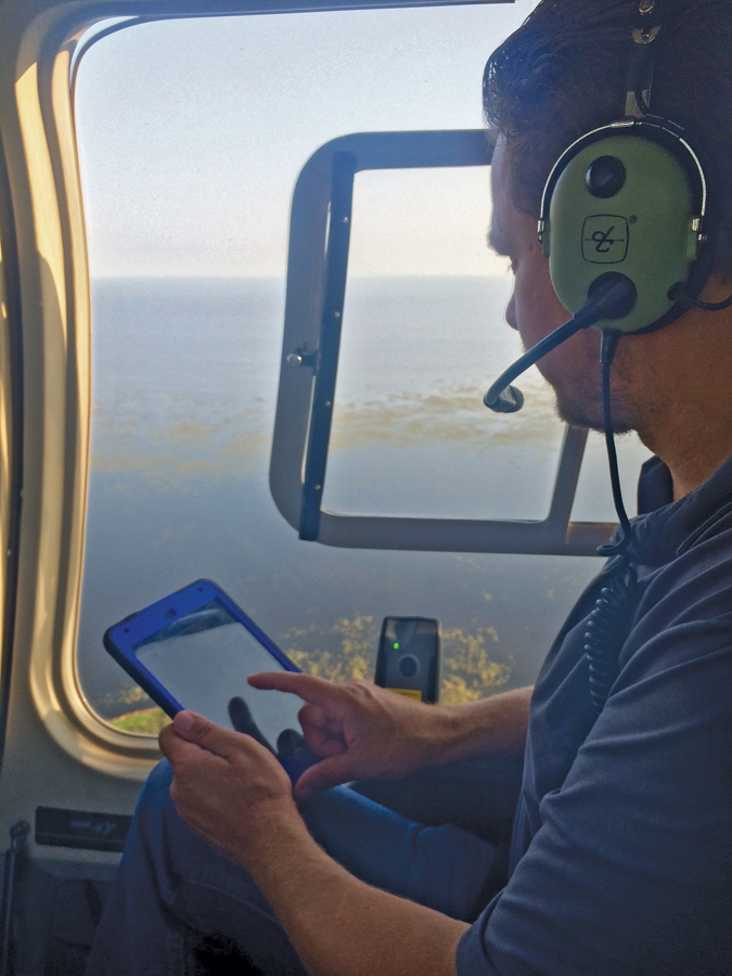
Rich Botta prepares to inventory flocks of wading birds from a helicopter.
“At that time, all of the field work was paper-based,” explains Spencer. “We took paper maps into the field and recorded data in paper notebooks. Our geospatial imagery was either prints or transparencies, and GPS technology was simply used for navigation. My primary focus was to cut the dependency on paper and make technology an integral part of operations.”
Fast forward to 2015, and the data collection scene for the ecosystem field crews look different. When crews embarked on their 2015 field assessments, they arrived with iPads, digital maps, and drop-down menus, as well as professional-grade, Bluetooth-enabled GNSS units.
The culmination of a ten-year transformation: this new combination has not only shred the paper trail for the department; it is giving staff the smart tools they need to more efficiently and accurately monitor and map diverse vegetation species as well as bird activity. Plus, with the mobility and flexibility to create seamless data flows from the field to the office, information can be shared in real time, key tasks are being reduced from weeks to one day, and deliverables are being produced with higher confidence.
The Size of It
Based in West Palm Beach, SFWMD covers 16 counties stretching from Orlando to the Florida Keys, including the unique and intricate Everglades freshwater wetland. The oldest and largest of the state’s five water management districts, the 67-year-old SFWMD strives to maintain a delicate balance between safeguarding the water needs of the natural environment and the competing water-supply demands of 8.1 million residents.
As part of its extensive responsibilities for south Florida’s rich environment, the District has been at the helm of significant natural resource initiatives. Two of the most ambitious ones are the Kissimmee River Restoration Project (Kissimmee Project) that aims to repair detrimental damages from overly aggressive past flood-control measures, and the Lake Okeechobee Protection Program (Okeechobee Program) that was designed to address years of harmful runoff, extreme water-level fluctuations, and invasive plants.
The extensiveness of the Kissimmee Project and the Okeechobee Program required the SFWMD to form dedicated teams to evaluate the environmental changes and ensure that the ecology of the region is thriving throughout the restoration phases. The lake and river ecosystems section (LRES) was that team.
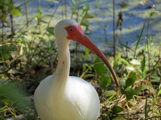
Wading bird populations, such as the White Ibis, are key indicators of an ecosystem’s overall health
“The whole section was launched for the purposes of measuring the success of the ecosystem’s response to the projects,” says Spencer. “The problem from the beginning is that we were trying to monitor and map a very fluid environment with static, labor-intensive tools.”
With the size of the monitoring areas—the Kissimmee Project is about 44,200 acres and Lake Okeechobee’s surface area is 467,000 acres—they needed a versatile and accurate set of tools to enable their environmental scientists to assess the health and wellness of the vegetation and wading bird populations, both of which are key indicators of the ecosystems’ overall health.
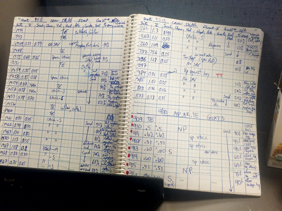
As recent as 2006, all field work was paper-based at the SFWMD.
Although Spencer started to bring in digital alternatives to paper for both field and office work, they were still plagued with location data inaccuracies, technical failures in the field, cumbersome data inputs, and interoperability issues.
That all changed last spring when they started using a new data-collection system: a Trimble R1 GNSS receiver connected via Bluetooth to an iPad running Esri’s Collector for ArcGIS app. With the 2015 field assessments approaching, the LRES chose to test the viability of this new approach in mapping vegetation conditions in the Kissimmee Project study area and wading bird populations in Lake Okeechobee.
“With this technology, not only can we get sub-meter spatial accuracy, but those high-accuracy GPS points feed into the iPad and the Collector software in real time,” says Rich Botta, an environmental scientist with SFWMD’s LRES. “That ability to collect GPS points and have them fully integrate with other devices and software is a significant benefit. It’s much more efficient, it’s more accurate, it’s easier to use, and we get better results.”
Monumental Restorations
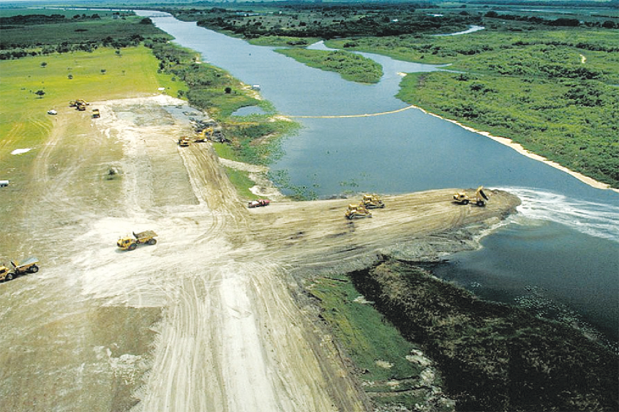
The Kissimmee River once meandered for 103 miles through central Florida, and its floodplain stretched up to three-miles wide. It was also prone to flooding by heavy seasonal rains.
The Kissimmee Project aims to return a natural flow to 40 miles (one-third) of the river and restore about 25,000 acres of wetlands by 2019.
Public outcry to reduce flood damage to property led to an aggressive flood-control project in 1960 that drained much of the original floodplain and channelized the meandering river to prevent catastrophic flooding. Although the 56-mile canal was successful in significantly reducing flood impacts, it had profound environmental impacts on the river, its floodplain, and the wildlife that thrived there.
Since 1992, the SFWMD, in partnership with the US Army Corps of Engineers, have been working to restore a portion of the river and the floodplain’s ecological integrity through the Kissimmee Project. The aim is to return a natural flow to 40 miles (one-third) of the river and restore about 25,000 acres of wetlands by 2019.
Called the “liquid heart,” Lake Okeechobee is the largest lake in the southeastern United States and is a critical part of the greater Everglades watershed, providing natural habitat for fish, wading birds, and other wildlife, as well as essential water for people, farms, and the environment. Over the past few decades the lake and its watershed have suffered from agricultural and urban activities, extreme water-level fluctuations, and invasive plant species.
In 2000, the Okeechobee Program was launched to rehabilitate the lake and enhance the ecosystem services it provides, while maintaining water supply and flood control. The SFWMD is part of a large team of agencies working to fulfill the project goals.
Kissimmee River Restoration
Given the size of the Kissimmee Project monitoring area, the LRES uses both airboats and helicopters to survey and map the vegetation: field work that is coordinated with aerial surveys flown every three years for large-area coverage. The focus is on studying and mapping the predominant emergent vegetation––plants above the soil or water surface.
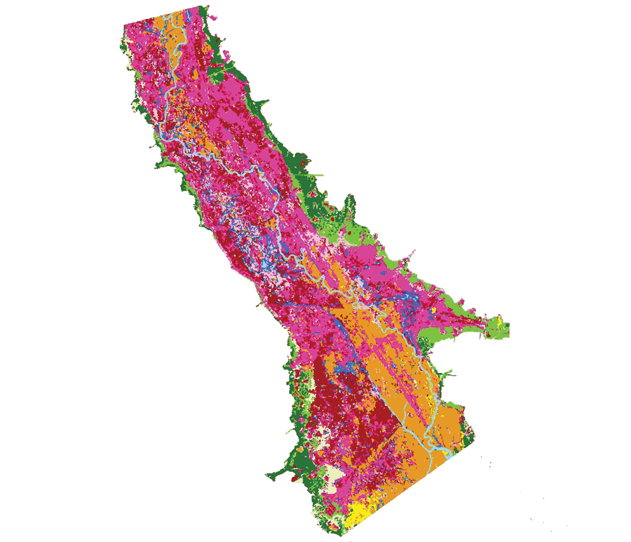
A vegetation map from 2011; Spencer is using eCognition to help classify the 2015 field study data and create an updated map.
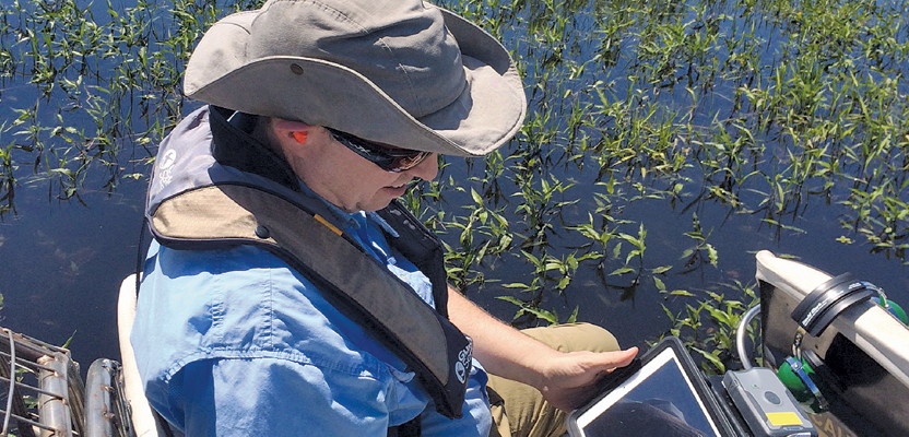
In the past, Spencer would print out reams of paper before entering the field. For the 2015 field work he used only a Trimble R1 and an iPad loaded with all the relevant apps and maps he would need. With the airboat, he used the receiver in combination with the iPad to navigate to predetermined sample areas.
Once at a location, he stopped, located the center of the vegetation cluster, and captured a precise GPS ground-control point (GCP) of that population, which was stored into the Collector app to provide an accurate position for mapping that vegetation class. Using templates, Spencer recorded an array of attributes such as the plant type, its areal extent, and its health, and he attached photos of the area.
Data collection complete, he navigated to the next location and recorded the vegetation there, a process he repeated every week for about six hours a day from April to June.
Using the receiver, Spencer collected around 475 sub-meter-accuracy GCPs, about three times the number of GCPs he could acquire previously. The GCPs are used both to generate signatures for air-photo-based vegetation classifications and to assess the accuracy of the final vegetation maps produced.
“The GNSS technology allows me to take more points, and higher-quality points, in the time we have,” says Spencer. “These points allow me to create spectral signatures so I can better distinguish individual plant classes on the air photos and map them across the whole restoration site.”
Between airboat trips, Spencer also carried out vegetation surveys with a helicopter.
Once Spencer reached a predetermined location, the pilot hovered over the wetland, and Spencer collected several GCPs with the receiver, recorded plant attributes, and took pictures of the vegetation below––all in less than 90 seconds. Then he flew to the next sample area. In all, Spencer collected another 450 GCPs from the helicopter, giving him about 900 data points for the final maps.
With only four hours to collect data over the whole Kissimmee Project study area, efficiency is critical. The new system enables him to collect more information in less time—with less crew.
“In the past, I’d have another colleague, a laptop running Esri’s ArcPad, an old backpack GPS unit, and paper maps in the helicopter,” says Spencer. “I often couldn’t take data points fast enough, so I hand-wrote notes while my colleague took pictures of the vegetation. And we usually needed the full four hours to complete the work. With the R1 and iPad, we have reduced flight times by nearly 50%, and I can acquire all the data, including photos, myself.”
In addition to the new field system, Spencer is also developing a more automated and accurate map production system using an image-analysis and land-classification software, in this case Trimble’s eCognition. Historically, Spencer manually drew polygons around vegetation populations on the digital infrared air photos, named each by its signature, and used those specific polygons to map the wetland vegetation. This time, he will put all of the data points he collected in the field, along with the 2015 aerial imagery, into eCognition to automatically classify and map the vegetation.
“With significantly more sub-meter accuracy data points, I’ll be able to classify the vegetation much more accurately and quickly,” says Spencer. “And I’ll be able to repeat and customize this process to produce any type of map needed. This flexibility and detail will help to better measure how well the vegetation and wildlife is responding to the Kissimmee Project.”
Lake Okeechobee Protection
The flexibility and spatial detail of the LRES’ new data collection system is also benefitting the environmental scientists who are tracking the vitality of the vegetation and foraging habits of wading birds around Lake Okeechobee.
Similar to the work on the Kissimmee River, Botta and colleagues use a combination of airboats and helicopters to study and inventory submerged vegetation, emergent aquatic vegetation, and wading bird foraging locations.
With Lake Okeechobee’s marsh extending more than 98,000 acres, mapping the emergent vegetation entirely by airboat is untenable, so Botta and colleagues acquire this field data predominantly by helicopter.
For the 2015 assessment, a two-person team flew weekly surveys of the entire lake, collecting hundreds of precise GCPs of dominant vegetation species with the R1 receiver, as well as the attributes of each plant community. When needed, crews used airboats and the R1/iPad combination to take additional GCPs at predefined locations around the marsh’s edge for photo interpretation to classify and map the vegetation. The result of the intensive data-collection work was a classified vegetation map showing the dominant and subdominant vegetation present in the entire marsh.
“Data entry is significantly faster with the new system,” says Botta. “And the increased accuracy helps us better match the GCPs to the aerial imagery, giving us a more precise picture of the vegetation.”
The data-collection speed is particularly important for accurately mapping wading-bird foraging locations. The crew needs to quickly count the flock, as well as to record, photograph, and GPS-locate it before either the birds or the helicopter fly away.
For each flight, there was one dedicated observer with binoculars in the front and one person in the back with the R1 and iPad, ready to take notes and photographs and collect GPS data. The target species are easily identifiable birds such as White Ibis or Snowy Egrets in flocks of at least 50. Once a flock was spotted, the crew circled the colony to photograph it, record its GPS position, note its species, and note the vegetation types present.
They covered the entire lake every other week; within 24 hours of each flight, they had a classified map showing the location of each flock of birds and the ecological conditions found: information that could be immediately shared with project managers.
“With the old system, accuracy was a constant problem, and it was difficult to easily share data,” says Botta. “Now we have the spatial precision we need, and since the data is user-ready the instant we land, we can share that information in real time.”
The improved data collection efficiency and ability to readily share information is also attracting colleagues at SFWMD who see the benefits of this versatile system for their own work. The combined system may indeed become the new normal for acquiring data in the field.
“Although we have paired the Trimble R1 with iPads, we could easily use it with any smartphone or mobile device,” says Spencer. “And it’s so easy to use, I could pull people off the street and have them use it.”
Perhaps “recruiter” will be another position to add to Spencer’s list of professional titles.