Category Archives: Spatial IT/GIS
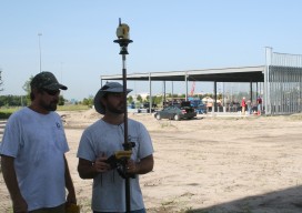
Going Smaller to Grow Bigger
Editor’s note: Some of the more significant changes in workflows and data management in surveying field and office operations have come in recent years: a move to mobile, robotics, and cloud-enabled software suites. But, how has implementation played out? We offer the following case study of a forward-thinking surveying and mapping firm that has implemented...

Fighting Crime with GIS and Lidar
In spring 2013, the Bureau of Alcohol, Tobacco, Firearms, and Explosives (ATF) needed to track and apprehend major targeted offenders in Weakley County, Tennessee. They asked the county 911 department to assist in creating GIS-based intelligence packages to be used as a critical tool for this job. This request, plus an increased demand for more...

Creating the Futuristic Worlds of 3D
We interviewed Autodesk’s technology futurist Jordan Brandt, appropriately, in the Autodesk Gallery at their One Market offices in San Francisco. The Gallery, open to the public and the venue for monthly techie events, is a showcase for eye-popping examples of the types of innovation Autodesk’s customers have been producing for more than three decades. It...
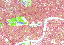
Open Source in the UK
Contrary to popular belief, it was neither the UK government nor Britain’s national mapping agency, Ordnance Survey, who started the UK open-source movement. Although open source was present and used in the UK before 2006, it was The Guardian newspaper that started a campaign called “Free Our Data,” which called for the raw data collected...
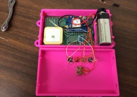
Low-cost DIY GPS Data Logger
It wasn’t that long ago when the ability to create a functioning GPS device was reserved for the big companies, academics, and those with money to burn. Today, thanks to the ever-increasing demand for consumer-grade GPS electronics (such as those in every smart phone), the availability of GPS integrated circuits (chips) has dramatically increased, while...
Crafting The Future via Geodesign
Geodesign is on the move. While the term may be new to some, it is an old concept getting new life via modern technology: how the science of geography should inform our methods of design. In that sense, geodesign is an applied science, and we humans have been doing it naturally since the dawn of...