Category Archives: Spatial IT/GIS
Transportation
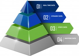
Traffic Analysis in Real Time Until recently, geospatial experts have been unable to truly record traffic data because there hasn’t been a way to get a near-perfect record of traffic data at the lane level. Yet, it’s more evident now than ever that the need for near-perfect data is becoming a critical requirement for the...

Geographers’ Tour – On Intersections: Vancouver
A comment came by on Twitter recently saying, “Geographers always want window seats on planes and trains,” and it was a big Favorite. We understood because geographers are living spatial scanning machines, a constantly analyzing nexus of the places, spaces, connections, patterns, and relationships that surround them. Thriving on constant extrinsic access to the world,...

Hypervoice
Rendering 4D Sensed Environments In the world of personal communications, the white-hot winds of change shimmer, blurring the present and obscuring our view into tomorrow. We are in the midst of a massive revolution, blasting away much that went before it. It can best be summed up like this: the future is all about ubiquitous...
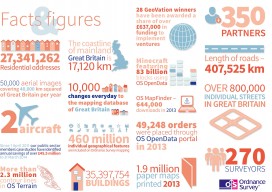
Ordnance Survey go GovCo
A new model for operation of The Ordnance Survey of the UK has been announced. This looks promising for the future of the customer and it is good to note the reference(s) to the use of the term “Open & free where possible”. It certainly looks like there are some exciting times ahead for the...
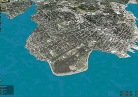
CLIVE: Communicating Risk in 3D
Above: The current sea level and coastline of the city of Charlottetown on Prince Edward Island, Canada. Static 3D models of topography and buildings are commonplace in both technical and popular geospatial software. There are still very few 3D tools, however, that enable users to geo-visualize dynamic phenomena, such as the effects of climate...
Call for Abstracts for 2015 GIS in Action!
Mark your calendars for May 4-6, 2015 and join us in Vancouver, WA at the Hilton Vancouver Hotel and Conference Center for the 2015 GIS in Action conference. This year’s conference is jointly sponsored by the Oregon-Southwest Washington Chapter of URISA (ORURISA), Washington State Chapter of URISA (WAURISA), and the Columbia River chapter of ASPRS...