Category Archives: Surveying
Upcoming Young Surveyors Network North American Meeting
Register now for the Young Surveyors Network (YSN) 2nd North American Meeting – Minneapolis MN – Feb 10th 2016 The FIG Young Surveyors North American Network will hold its next meeting in conjunction with the Minnesota Society of Professional Surveyors (MSPS) Annual Conference. The 2nd FIG Young Surveyors North American meeting will be held on...

Outlook 2016: 40 Under 40
In this annual issue focused on the future, we offer “40 under 40” (or “40<40”): a collection of profiles of motivated and noteworthy young professionals under 40 years of age. It is our wish that these profiles will honor those who work tirelessly to promote geospatial fields and to provide inspiration for young people considering...
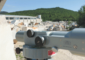
Quarry Monitoring
In Slovenia, a team monitored slope stability in an open-pit quarry using a classic, optical precise level and Invar rod. Editor’s note: Cost-benefit analysis dictates that, for open-pit mines and quarries, steep slopes allow for the most efficient extraction of resources but at an increased risk of slope failures. This adapted paper outlines an example...

Stretching Surveyors across the Water
Surveying the Gorgon Jetty Project on Barrow Island off Western Australia involved integrating structural, mechanical, and hydrographic surveying technologies and skills. Barrow Island is described by some as Australia’s answer to the Galapagos Islands. The 202 km2 (78 mi2) island and its surrounding ocean are home to diverse and unique fauna, including marsupials, reptiles, sea...
Sarah Winter
Director of SurvCE Programming Division at Carlson Software Carlson has bragging rights in not only developing new approaches but also responding to and adopting new features from a very loyal user base; Sarah Winter is a key member of the software development team at Carlson. She’s from Sissonville, West Virginia, is a mother of three, and...
Brian J. Naberezny
Instructor of Surveying, Department of Civil and Environmental Engineering, the Pennsylvania State University Brian Naberezny’s experience includes traditional boundary and land development surveying; software development for several DoTs; serving as a geospatial analyst and operations manager for a Department of Energy-funded research project: working as a consultant developing and implementing technological solutions for surveying and...