Category Archives: Surveying
A Correctly Weighted Least Squares Adjustment, Part 2
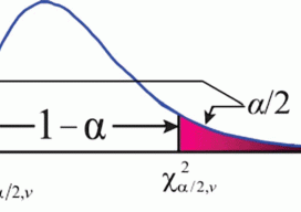
Estimating Uncertainties In the previous article (January 2016), I point out the unreliability of sample standard deviations as estimates for population standard errors when the number of repeated observations is very small, which is typically the problem in surveying. In this article I look at how we can estimate the standard errors for observations based...
United Surveyors of Arizona
United Surveyors of Arizona announces the launch of a new professional organization and opens membership opportunities [Editor’s note: xyHt is always happy to publish news of organizations or initiatives that help promote land surveying and other geospatial professions. Strong participation by individual practitioners in professional associations and societies at the local, state, national, and international levels...

Future of Surveying Forum
On January 22, 2016, the National Council of Examiners for Engineering and Surveying (NCEES) kicked off a national initiative to examine the future of the surveying profession in a face-to-face forum with representatives from 18 key surveying associations, educational institutions, and practitioner constituencies. As one of the media outlets invited (to help with outreach), xyHt will be providing...
A Correctly Weighted Least Squares Adjustment, Part 1
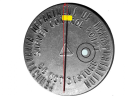
Problems from using computed standard deviations. According to the 2011 Minimum Standard Detail Requirements for ALTA/ACSM Land Title Surveys, “‘Relative Positional Precision’ means the length of the semi-major axis, expressed in feet or meters, of the error ellipse representing the uncertainty due to random errors in measurements in the location of the monument, or witness,...
NGS Finds a Real-Time Solution
An Iowa RTN contributes to the National Geodetic Survey’s Geoid Slope Validation Survey of 2014. The gravimetric geoid model will become the zero-height surface for the new geopotential reference frame, which will replace the North American Vertical Datum (NAVD 88) in 2022. The Geoid Slope Validation Survey of 2014 (GSVS14) is the second survey conducted...

The Long Drive
Topcon Positioning Systems’ president and CEO Ray O’Connor talks about automation, integrated solutions, smart phones, golf, and the coming era of continuous representation of reality. The occasion of our conversation with Ray O’Connor was a visit to the headquarters of Topcon Positioning Systems in Livermore, California, which included a tour of their manufacturing facility, a...