“Like cinders… infernal… leafless…”
Charles Darwin wrote those words in his diary on September 16, 1835, after setting foot for the first time on the Galapagos. Darwin, whose scientific work in the far-flung archipelago considerably changed our understanding of how life on Earth evolves, was a keen observer of nature. And on that day, while working onboard the ship HMS Beagle, he scribbled his initial impression of the islands as “little signs of life.”
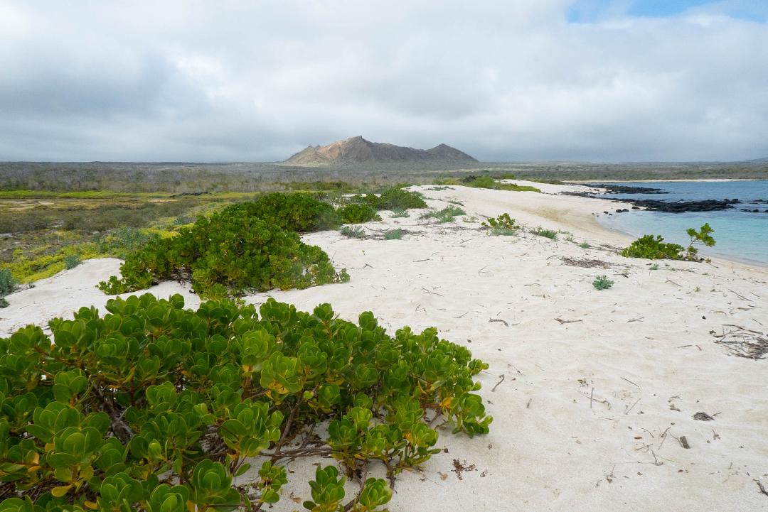
The natural landscape of the Galapagos islands. © Amy Tian
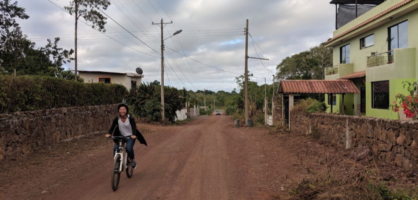
Biking to capture street imagery in the Galapagos. © Chris Beddow
Yet that’s not the case anymore, at least according to Chris Beddow. Fast forward to June 2019 and the Galapagos that Beddow saw upon his arrival was teeming with life, and not just the wildlife type. Yes, the giant tortoises, iguanas, and finches are still thriving—but so too are human communities.
Beddow is a solutions engineer at Mapillary, the street-level imagery platform based in Sweden. He flew to the Galapagos to help a team of researchers map the towns on the main islands.
“From the airport to my hotel, I have passed through a bit of rain forest, farm pastures, power lines, bicycle lanes, flocks of birds, and a bustling small town with a Mediterranean port feel,” he says. “The bus that I took from the airport to my hotel even had to stop twice to let iguanas wander off the road.”
Barely a few hours in the remote landscape and it is clear to Beddow that both wildlife and humans are competing for the same limited resource in the islands: space.
Origin of Spaces
Beddow met up with Daniel Zünd and his mapping team at Santa Cruz Island to join them in collecting street-level imagery using Mapillary. Zünd is a fellow of the Mansueto Institute for Urban Innovation at the University of Chicago. His research work focuses on urban systems, and the dynamics and patterns that they exhibit.
“I wanted to study the urban system of the Galapagos because its remoteness makes it a perfect case of the dynamics of small urban agglomerations,” says Zünd.
The Galapagos archipelago spreads out in the eastern Pacific Ocean, 1,000 kilometers (600 miles) off the coast of Ecuador. They cover about 7,700 square kilometers (3,000 square miles) or roughly six times the land size of Los Angeles. The main urban centers of the islands are huddled in the coastal towns of Puerto Ayora on Santa Cruz Island, Puerto Villamil on Isabela Island, and Puerto Baquerizo Moreno on San Cristobal Island.
What draws people to flock in these coastal towns located a thousand kilometers off the coast of Ecuador is its booming tourism industry. These days, people reside in five of the more than 100 islands where only wild fauna used to flock. And although the human population remains small, estimated to be around 30,000, it has grown steadily from only a few hundred fisherfolks 50 years ago.
Much has definitely changed in the islands since Darwin’s time. Low-rise houses and buildings have since sprung up, while roads ceaselessly sprawl inland. And if you zoom in on any online satellite map of the Galapagos, you will see that the towns and streets have already encroached into the natural landscape. Undoubtedly, urban space is the new evolving species in the islands.
“Currently, the urbanized areas and the nature parks feel like two distinct areas, almost two different worlds that seem to fight against each other,” describes Zünd. “Still, this should not be the case because tourism is the main economic driver in the islands, relying heavily on the archipelago’s unique ecosystem.”
Zünd says that their research will provide different kinds of spatial analysis to aid the planning efforts of local authorities. “We hope that our work will help the locals to better understand the current urbanization process and use this knowledge for a more sustainable development,” he explains.
“One of the projects we are working on is with Amy Tian. Together we are evaluating the potential of solar energy production in the islands by mapping the existing rooftops, thus doing away for the opening up of additional space,” Zünd said.
Tian is an undergraduate student majoring in biology (ecology and evolution) and public policy at the University of Chicago. “My interest in spatial mapping grew out of my studies where I learned how to use GIS,” she says. After studying GIS, Tian now appreciates how transformative geospatial tools can be to understand spatial urban interactions and to create innovative solutions to real-world problems.
“The mapping project in the Galapagos is especially exciting and inspiring to me because I am learning how we can use research to improve urban planning and policy in developing regions,” explains Tian.
HMS Bicycles
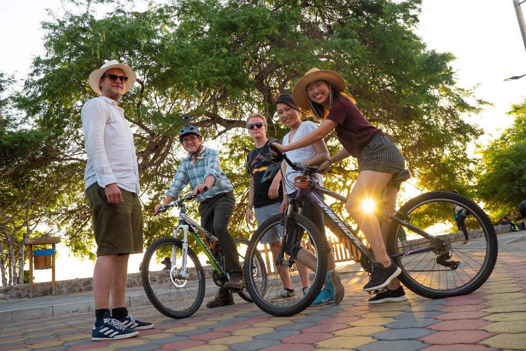
To collect street-level imagery in the towns, Tian and three other student researchers went around on two-wheelers in the streets of Puerto Ayora and Puerto Baquerizo Moreno, the two largest urban centers in the Galapagos.
“We rented bikes and attached 360-degree cameras (GoPro Fusion) on top of our helmets,” she says. And to make sure that they capture enough imagery, “the cameras were set to take a geolocated photo every four seconds,” adds Zünd.
Since there was a lot of ground to map, the students teamed up by biking out in pairs to cover specific areas, with one student wearing the camera while another was in charge of navigating the streets.
“We were pretty efficient and managed to even finish mapping earlier than expected,” says Tian. They spent about two weeks of mapping on bikes.
The sluggish Internet connection in the islands, however, made it impossible to upload the gigabytes of imagery data to the Mapillary platform in a reasonable time. “We had to wait until Beddow could return to mainland Ecuador to send the images to Mapillary,” says Zünd.
Back in his hotel in Quito, Ecuador’s capital, Beddow immediately uploaded the images to the Mapillary platform. He also asked the Mapillary backend team in Sweden to prioritize the processing.
“The team didn’t have to worry about this while they waited for the opportunity to see the resulting computer vision extractions,” he says.
The Galapagos islands’ 360-degree street-level imagery can now be viewed in the Mapillary website.
“My specific role at Mapillary is not only to help people solve real-world problems with our technology, but it also involves targeting specific cases that prove what Mapillary can achieve so that we can share it as an example to other industries,” says Beddow.
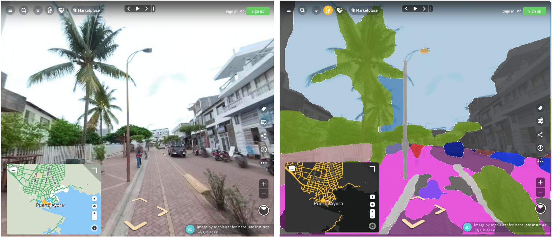
The main street of Puerto Ayora in the Galapagos is rendered as 360- degree imagery (left) in Mapillary by stitching together several images. Mapillary also uses the same imagery to divide the street objects into discrete units (right), namely, road, side walk, vehicles, p ole, fenc e, buildings, sky and vegetation. View the imagery here:www.mapillary.com/map/im/SJLg5B-MkwAZLmHM3DSbeQ
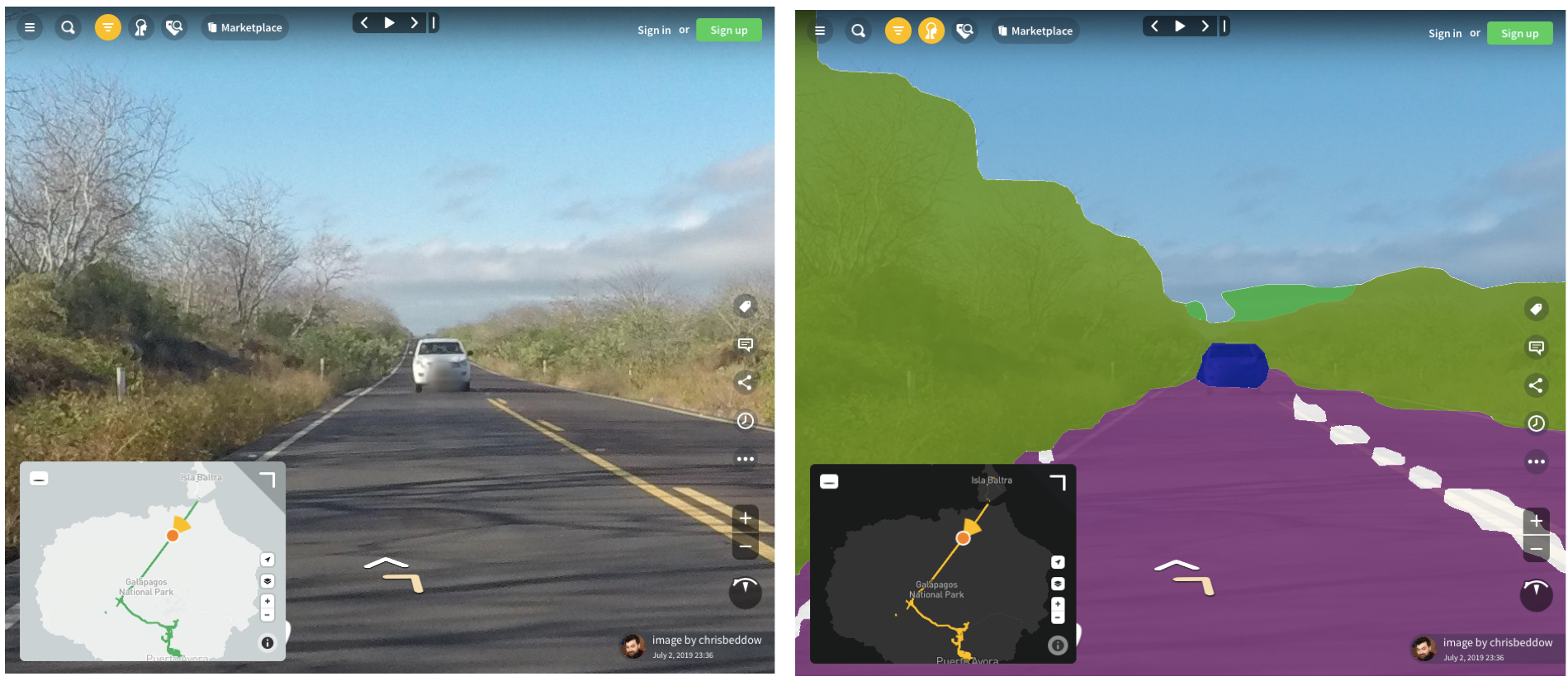
Mapillary’s computer vision technology uses the 360° imagery (left) of a scene captured in a rural highway in the island of Santa Cruz in the Galapagos, to identify several street objects (right) such as the car, road, lane markings, vegetation and sky. View the 360° imagery here: www.mapillary.com/map/im/Stomyoc-h0xhLN9ytiiuzQ
How Mapillary Creates 360° Imagery
Thanks to the active imagery contribution of its users, Mapillary is currently the world’s largest street view platform. It now counts over one billion images that cover around six million kilometers (3.7 million miles) of streetscapes. In June of this year, Mapillary was acquired by Facebook.
And as a technology that is grounded on volunteered geographic information (VGI), Mapillary relies on several user-friendly tools (mobile app, web interface, desktop application, command-line) so that its users can seamlessly upload street images and videos to its databases.
“Mapillary appears very simple on the surface: any person, anywhere in the world, can upload a geotagged image,” says Beddow, “yet the complexity is in what happens in the background.”
For example, as Zünd and Tian were moving around on bikes collecting street images with GPS-embedded devices, the device was also simultaneously geotagging each image, capturing its x and y coordinates and time data. Then as soon as a geotagged image is uploaded in the Mapillary platform, it enters a processing pipeline that starts with computer vision analysis.
“In this initial segmentation stage, every pixel of the image is classified as belonging to some category, such as sky, vegetation, building, road, sidewalk, car, cyclist, or fire hydrant. The static items are then retained, while the dynamic items—humans, cars, trucks, bikes, even birds—are discarded,” said Beddow.
The research team in San Cristobal Island, the Galapagos. From left, Daniel Zünd, Sam Joyce, Ryan Cutter, Amy Tian, and Jein Park. © Amy Tian
The next step goes even deeper. By comparing different images using a process called Structure from Motion (SfM), a 3D model reconstruction of a street scene can be created.
“Mapillary’s open source OpenSfM library matches pixels between images that are near one another. This process makes it possible, for example, to locate a fire hydrant in my photo from January that overlaps with a similar fire hydrant in a nearby photo taken by someone else from March,” Beddow says. “This matching allows for a three dimensional reconstruction of the street scene. Then, when the groups of pixels in the 3D model are compared against the initial computer vision segmentation stage, it becomes possible to know where objects such as a fire hydrant, a crosswalk, a traffic light, or a utility pole are located.”
And how does the series of images end up on a street map?
“Mapillary is very network-centric in that the geotagged images are often captured from a road, path, or an otherwise navigable route,” explains Beddow. These geotagged images are stitched together into a trajectory of what is called a “sequence” in Mapillary parlance. “After uploading a geotagged image and processing it, you can then view it on a street map, navigate to the left, right, forwards, and backwards, either within the same sequence, or to another sequence captured by a different user, at a different time,” he adds.
As for the individual objects that were segmented by computer vision, they are converted back to point data with their particular x and y coordinates. “The result is a point dataset similar to lidar,” says Beddow. “Thus it can show, for example, utility poles which you can overlay on a satellite or graphical map and compare to the already existing map of roads or buildings.”
Dogs, not Darwin’s Finches
Certainly there are many challenges that one could face while working in a far-flung place such as the Galapagos. According to Tian, the rough terrain and roads with steep incline made it very difficult to collect data on bikes. And then there were also the unleashed dogs that roamed the streets.
“The dogs would growl and chase after us while we were on our bikes collecting data,” recalls Tian. “To get past this challenge, we either had to pedal for our lives or collect data on that street another day.”
Beddow also describes his brush with the local dogs. “A few times I was whistling and yelling to pacify or distract a barking dog so that the other person wearing the camera-mounted helmet could focus on keeping their head level,” he says.
“It is very important to maintain the level position of the camera since tilt, roll, and yaw can have an impact on the entire image processing pipeline and precision,” emphasizes Beddow.
Despite their canine challenges, Zünd is pleased with what they have accomplished. “I think the approach to mapping the urban space in the Galapagos with cameras on helmets and riding around with a bike has proven to be a cost efficient way, and with great results.”

Daniel Zünd and Chris Beddow (seated, left to right) in Puerto Baquerizo Moreno, checking the images collected using a 360° camera that was mounted on top of a bike helmet. © Amy Tian
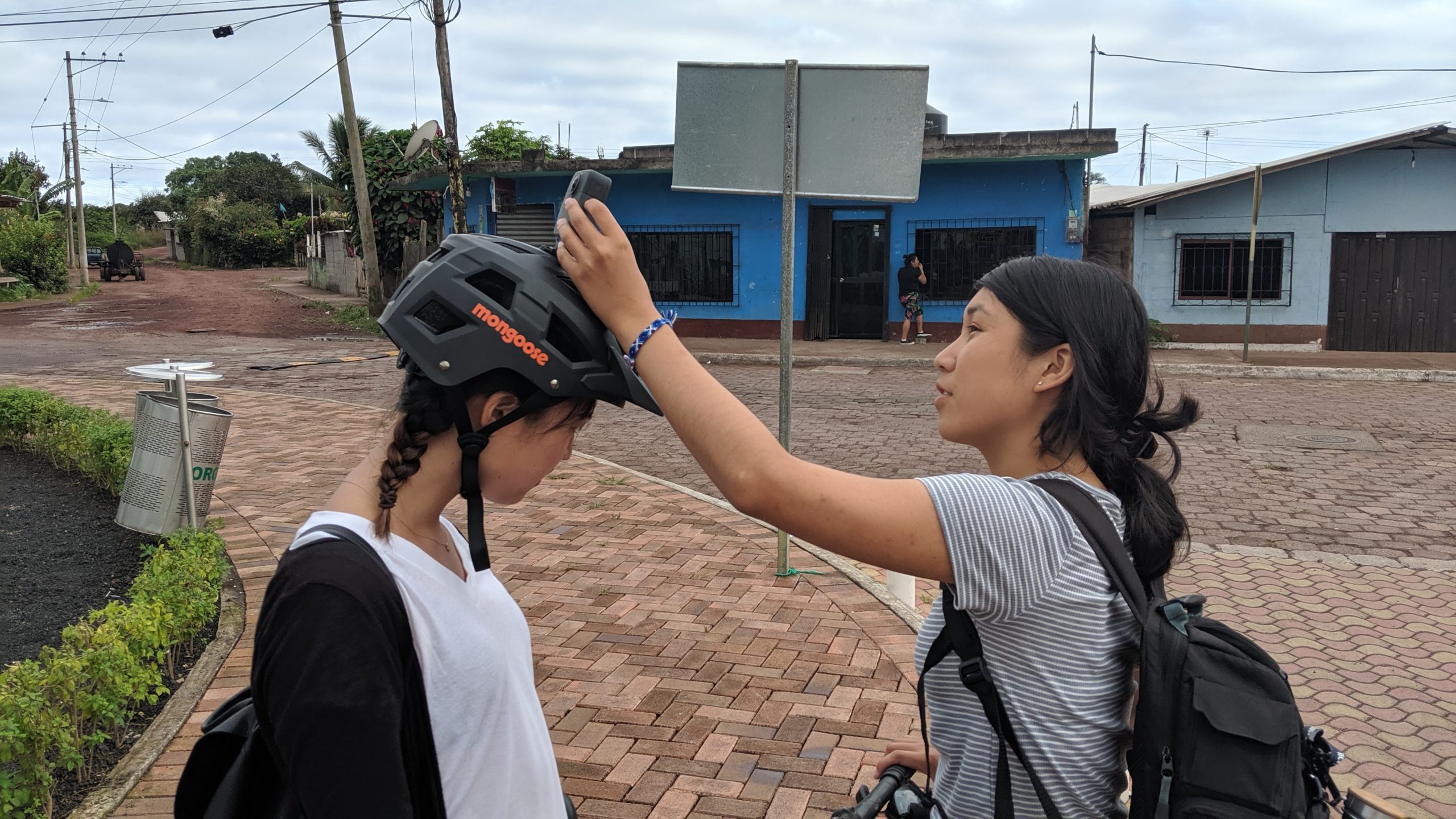
Amy Tian installs the 360° camera on top of Jein Park’s helmet before capturing street imagery on bi ke. © Chris Beddow
Mapping Streetscape Diversity in Other Islands
With the current crop of streetscape imagery that they have collected in the Galapagos, Zünd and his team can now continue to monitor the evolution of urban spaces there. He underlines, nevertheless, that “several more years of street-level imagery are needed to be able to understand the urbanization process in the islands.”
“Seeing the potential of Mapillary, we are already working on additional research projects in the area,” he says. This includes their work on image processing of street-level data as a cost-efficient way to build smart cities and enable citizen engagement.
They will also start working on comparing urban expansion in other remote islands around the world. “We will use the Mapillary street-level data and extract information to compare the urban-rural patterns in the Faroe Islands in the North Atlantic Sea, in Reunion Island in the Indian Ocean, and in Santa Catalina Island off the coast of California.
“Being remote locations, the street maps and street-level imagery in these areas are often not up-to-date nor do they exist at all,” says Zünd. “Unfortunately, those that are found on OpenStreetMap or Google Maps are often from tourist spots.”
Beddow believes that Mapillary’s technology will definitely prove useful in mapping isolated islands. “The advantages of Mapillary over other data collection methods are that it is quick to implement, compatible with low-cost cameras, and enables one person to collect a vast amount of acceptable data that may take a professional survey team months or years to collect with maximum precision,” he says.
However, Zünd thinks that there is still some way to go for less developed places in terms of image data analysis. “Currently, most computer vision algorithms that extract information from street-level imagery are trained in more developed countries,” he says. “For example, in the Galapagos we were very interested in extracting rebars on buildings from the images and geolocating them. This was not possible since the algorithm was not yet trained to do so. Rebars are of low interest in richer countries and are not as prominent.”
As with any useful technology, Mapillary’s computer vision extraction technique will surely improve with time as more users add even more street objects to its platform. But could we also hope the same improvement for these once desolate yet pristine islands that Darwin saw some 200 years ago? The answer may take years to come.
Beddow, who is glad to have contributed to the Galapagos research team by bringing 360-degree imagery to a new place, recalls a memorable trek that he did there.
“I managed to slip away on my own for a few hours to hike to the top of the very stout volcano at the center of Isla Santa Cruz. There’s a radio tower at the summit and a nice view over the thick forests of the island,” he says. “Reaching that spot really made me reflect how a place so known for biodiversity and natural beauty is at the same time very subjugated by humans.”