Editor’s Note: GNSS is a global amenity that all segments of society now rely on. While low-precision uses of GNSS can work with the default broadcast products alone, directly from the satellites, all high-precision GNSS uses rely to varying degrees on external “value added” data products. These products, such as enhanced clock and orbit data, are made available from networks of tracking and monitoring stations, hosted by combinations of government agencies, academic institutions, and commercial tracking networks. As you do your field work, recognize that an “invisible” global team of dedicated folks work on your behalf, providing vital resources.
The International GNSS Service, the premier cooperative network providing such products and related geodetic reference elements, is comprised of many such tracking, management, and monitoring centers. In continuing our examination of real-time GNSS, PPP, and PPP-RTK, we present this condensed version (the full version is online) of an academic profile of one of the most noteworthy centers, the Control Center at the BKG.
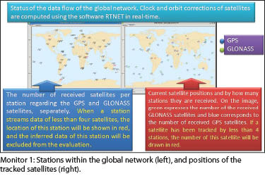
The Bundesamt für Kartographie und Geodäsie (BKG, German Federal Agency for Cartography and Geodesy) is one of the participating analysis centers that provides the International GNSS Service (IGS) with products for real-time applications. Products—orbit and clock corrections of the satellites—streamed from the Global IGS Real-time Service (RTS) refer to the International Terrestrial Reference Frame 2008 (ITRF2008). A detailed content description of the RTS products is listed in Figure 1.
Orbit corrections are provided in terms of three orthogonal components, in radial, transverse (along-track), and normal (cross-track) directions, in the Earth-centered, Earth-fixed reference frame (Figure 2). Clock corrections are evaluated as offsets to the Broadcast Ephemeris. After using corrections streamed by the RTS, the satellite position is referred to the “ionospheric free” phase center of the satellite antenna (for the Antenna Phase Center, APC streams) or to the satellite Center of Mass (CoM streams).
Real-time Products Provided by BKG
Data processing for the estimation of satellite orbit and clock corrections is conducted using the software RTNet (Real Time NETwork processing engine) in real-time. The RTNet software was developed by GPS Solutions, Inc. and was designed primarily for real-time applications, with additional uses for certain post-processing implementations.
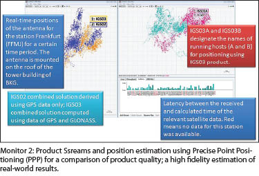
BKG provides to the real-time streams (RTS) two kinds of real-time products for corrections to the satellite orbits and clocks, which are denoted as IGS02 and IGS03. The IGS02 is a Kalman-Filter GPS combination computed using the software “BKG NTRIP Client” (BNC) developed in cooperation by the BKG and the Technical University of Prague.
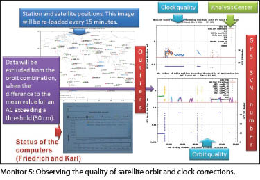
Orbit information in IGS02 is extracted from the current ultra-rapid solutions. To detect the outliers for orbit, a mean satellite position is determined using the solutions delivered by the individual analyses centers (ACs). When the difference to the mean value for an AC is exceeding a threshold, orbit corrections of the affected epoch for the affiliated AC are excluded. Clock corrections are derived according to the Kalman-Filter method through a combination of the satellite clocks estimated by the individual ACs.
The main difference between the IGS02 and IGS03 products is the orbit information used for the estimation of corrections. The IGS03 provides additions to the GPS and also GLONASS orbit and clock corrections. Orbit information in IGS03 is extracted from the ultra rapid product IGV. You might be familiar with ultra rapid orbits products, as most of the network RTK installations (RTN) take advantage of these types of enhanced orbit products (while single base RTK is limited to much less resolved broadcast orbits).
BKG also generates broadcast ephemeris (RTCM3EPH) using the BNC software. The “RTCM3EPH” product includes ephemeris of GPS, GLONASS, and Galileo satellites for disseminating to stationary or mobile users through the internet in real-time. The data stream is realized from the receivers within the real-time IGS global network. Incoming ephemeris are checked for plausibility, then merged, encoded in RTCM Version 3 messages, and uploaded to NTRIP (Networked Transport of RTCM via Internet Protocol) broadcasters with a high repetition rate. The complete set of messages is repeated every five seconds.
Control Center Monitoring
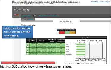
Data production with good quality is only possible by checking the availability and reliability of the product. This year, in the second floor of the historic mansion “Villa Mumm,” BKG has established a control center to monitor safety and productivity (quality, reliability, and availability) of real-time products needed for providing solutions acceptable for positioning at the sub-centimeter level.
To increase productivity, the computers of the network are monitored constantly using the software NAGIOS for capability and performance according to the predefined criteria. The control center delivers consistently high performance due to the dedicated efforts of its operators of BKG’s Division G2 “Satellite Navigation.” The six monitors used for the visualization of products are shown in Figure 3, with close-ups of each monitor in the online version of this article.
Yüksel Altiner, Peter Franke, Markus Goltz, Heinz Habrich, Peter Neumaier, Wolfgang Söhne, Andrea Stürze, and Erwin Wiesensarter are with the Federal Agency for Cartography and Geodesy (BKG) in Frankfurt am Main, Germany.
SIDEBAR:
Georg Weber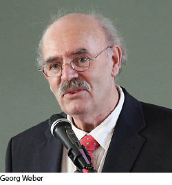 If you have ever used a network RTK rover, done post-processing, or submitted files for automated post-processing services like PPP, you owe Georg Weber and many of his peers a vote of thanks. Georg is a well-known figure in the international geodesy and GNSS communities. Beginning with degrees in surveying from universities in Frankfurt and Hannover, Georg later earned his doctorate in geodesy, also at Hannover.
United States and Canadian surveyors might be familiar with Georg’s work through presentations and papers at FIG, ION, CGSIC, and related trade conferences. Georg was instrumental in the development of BNC, the leading internationally accepted standard NTRIP application. Indeed, Georg’s tireless support and promotion of NTRIP (the real-time GNSS data protocol common to all network RTK rovers) has led some in the profession to call him the “godfather of NTRIP.”
It is Georg’s work towards international cooperation in the development and promotion of real-time high-precision GNSS that also earns well-deserved accolades. Even back when many users scoffed at real-time GNSS, Georg, who has a calm, subtly humorous way of convincing skeptics, has said of the matter, “Why produce a daily newspaper to only deliver it weekly?” Dr.-Ing Georg Weber will retire from the BKG at the end of January 2014; his colleagues have dedicated this article to Georg and wish him a long and happy retirement. We don’t know if Georg will remove himself from these GNSS matters altogether… expect to hear more from him.