For an electric company in North Carolina, GNSS technology in the field boosts efficiency and brings new opportunities to the operations crews.
High precision positioning is more available and affordable than ever, and one area of rapid adoption is in utilities: public, private, and cooperatives. Because of the economic challenges of the past six years, forward-thinking utilities have adopted not only these more efficient measurement technologies for asset inventory and field operations but also supporting software suites and modified workflows. Kelly Fritz, GIS supervisor for Wake Electric, offers the following insights gained during their implementation of these new tools.
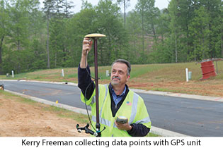
Wake Electric is changing the way it can stake and collect data in the field through new and innovative technologies. The electric co-op recently purchased centimeter-grade Global Navigation Satellite Systems (GNSS) units, Topcon Geodetic Rover System (GRS)-1s from Benchmark Tools. These all-in-one, handheld dual frequency, multi-constellation GNSS receivers/field controllers allow staking technicians to take advantage of digital “stakes” that are completely portable, greatly improving efficiency and workflow in the field.
Wake Electric is a cooperative electric utility serving over 36,000 customers near the Raleigh-Durham region of central North Carolina. Like the thousands of utility cooperatives, which include those for electricity, water, sewer, drainage, and irrigation, Wake maintains and operates its own facilities and outside plant (e.g. poles, overhead lines, vaults, transformers, etc).
The impression many people have about “handheld GPS” units is that they are sub-meter-only or even less precise, like recreational GPS, but these units represent the wave of combined data-collector/GNSS that are capable of centimeter accuracy (with the application of real-time RTK/RTN corrections), and they truly make digital staking possible. This new technology opens countless opportunities for Wake Electric’s field and mapping technicians to do their jobs faster and more precisely.
 For example, mapping technicians now have the ability to collect very accurate asset locations in the field and quickly update distribution datasets. This produces a more reliable data model that can help managers make critical decisions more confidently when restoring power to members during outages.
Having a centimeter GNSS unit has completely changed the way we approach our staking and mapping processes. We have two network ports set up with the NC Geodetic Survey for the GNSS Real Time Network (RTN). The NC Geodetic Survey maintains the North Carolina Continuously Operating Reference Station (CORS) network of GNSS base stations, which provides the information the unit needs to apply corrections to the raw field data. This allows the unit to run real-time calculations via an integrated cell modem and achieve centimeter accuracy at the collection point. No post-processing is necessary.
To ensure the highest precision in use of these handheld units, Wake Electric uses an external GNSS antenna with integrated ground plane. One potential source of error for a handheld GNSS unit, when using the onboard antenna only, is that the operator is typically looking at it at waist level, and that limits the sky view and makes the unit more susceptible to multipath.
To reduce these errors, putting an external antenna on a full 2-meter pole is the standard practice for the crews. Because we frequently work in narrow right-of-ways that have limited unobstructed views to the satellites, we needed a performance antenna to provide increased satellite reception in those tighter areas. It’s made all the difference in the world.
 The GNSS unit also allows Wake Electric to import digital construction plans directly into the mobile controller and provide critical spatial information to the staking technician regarding the location of other utility and civil assets for the site. Thanks to our GNSS unit, we know exactly where to put our transformers, utility lines, poles, and other equipment prior to tree removal and grading. This gives us more confidence on the accuracy of our design, and, because the design is digital and portable, we don’t have to rely on plastic stakes alone.
The GNSS unit can eliminate the need for actual plastic stakes in the ground during the design process, though Wake Electric still uses them for visual cues for construction crews. However, if a plastic stake is missing due to grass mowers, tractors, people, construction equipment, etc., the staking technician can use the unit to place a new stake in the correct location within minutes of arriving on the site. While the majority of projects are wholly within well-established rights-of-way or utility-owned parcels, these tools help crews stay mindful of surveyed boundaries and help identify situations where land surveyors are called in; eliminating “eye-balling” makes for improved risk management.
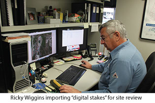
“Before we used digital staking, if we put our plastic stakes down on a lot before they did the grading, they would easily get moved or would fall over due to foot traffic on the construction site,” said Ricky Wiggins, staking technician for Wake Electric. “It was very costly and cumbersome to have to go back to the site and relocate the stakes. The digital staking saves us so much time and ensure accuracy the first time around.”
The GNSS unit can also be imported into the FieldEdit Staking software Wake Electric uses from the National Information Solutions Cooperative (NISC). FieldEdit Staking allows Wake Electric’s field technicians to quickly and easily update maps, build multiple, accurate, up-to-date staking sheets, and verify field information—all from a single interface. It also allows field technicians to conduct equipment and location maintenance, and it increases data accuracy by eliminating the need to handwrite information or rekey it into an intermediate application. Instead, staking information flows directly to the office and automatically updates the appropriate systems.
These two applications, the GNSS unit and the FieldEdit Staking software, work hand-in-hand and provide all the accurate and quick information field technicians need to do their jobs effectively, allowing easy creation and correction of staking data while streamlining the work-order process. The staking software and the GNSS unit use the same file formats, so the integration between the two is seamless. Information gathered by the GNSS controller can export directly into the NISC staking package software, and vice versa.
Noteworthy features of the GNSS unit include integrated cell phone with bright touchscreen display, built-in camera and compass, and increased memory, allowing Wake Electric to be even more efficient and connected while in the field. The mobile handheld unit has Wi-Fi as well as the cellular wireless capability, which makes it extremely portable and multi-faceted. Wake Electric’s three full-time and three part-time staking technicians have the ability to send images, data, and maps between the field and the office instantly, which translates to increased productivity as data and information can be shared without having to revisit the site repeatedly.
Another perk to the mobile device is that it allows operationally relevant elevations on a site to be obtained from the GNSS unit by one person rather than two people, streamlining work processes for the co-op. Depending on local site conditions, such as site view and sources of multipath, the technology provides accurate elevations ranging from 0.2’ to 0.6’, allowing Wake to achieve the same results, but without labor-intensive legacy methods. The GNSS unit also improves reliability at Wake Electric; it provides more accurate data that translates into more accurate outage prediction and asset location, which can reduce overall outage times.
Wake Electric technicians were initially trained on this new piece of technology through a comprehensive half-day training schedule, and after a few months of using the technology they had a follow-up half-day training to ensure the co-op was using the technology to the fullest. “It’s a sophisticated piece of technology, so the training was really helpful,” said Wiggins.
Another way Wake Electric has improved efficiency in the field is through their implementation of a data-access and -management toolset, iVUE AppSuite (also through NISC). AppSuite provides convenient access to important data for field crews via tablet devices, such as iPads and Android tablets. Wake Electric crews can manage service interruptions, easily check meter information and readings, update work orders, capture and upload images from the field, access staking sheets, get pick lists, oversee outage management, and manage active jobs in one place, from a single device. AppSuite makes staking easy and paperless; crews are able to receive and manage the staking information while onsite, using the iPad. AppSuite also allows field crews to monitor service interruptions from any location.
The GNSS unit is changing the face of staking, and AppSuite is a perfect partner to complement the efficiencies of the mobile GNSS device. Real-time, digital staking saves time, energy, and manpower resources in the field of mapping and staking. Wake Electric is getting more work done more efficiently and with more accurate results. The co-op is excited to be part of this progressive, cutting-edge technology, which is truly revolutionizing the way Wake Electric operates in the field.