Tag Archives: 3d mapping

xyHt Weekly News Links: 8/4/17
Dewberry Honored for Special Achievement in GIS Reps. Westerman and Moulton Introduce Bipartisan Geospatial Data Act | Congressman Bruce Westerman GeoCue Announces GNSS Direct Geopositioning System for Low Cost DJI Drones Nearmap Provides High-Rez Oblique Imagery and 3D Products in Ready-to-Use Service ILMF Call for Papers Deadline is August 14! Congressman Doug Lamborn Addresses MAPPS...
xyHt Weekly News Links: 6/23/17
EngineerSupply Announces New Supply Line of Nedo Surveying Spectra Precision’s New GNSS Receiver Provides Surveyors with a Powerful Multi-application GNSS Solution Digital image evaluation heading for new markets Seiler Instrument Chooses TerraGo Magic to Build its Mobile GNSS App Platform Leica Geosystems offers complete imaging solution OrbitGT Announces Mobile Mapping Cloud Platform 3dmapping.cloud Property Drone...
Weekly xyHt News Links: 6/16/17
RIEGL has received the Sebastian Sizgoric Technical Achievement Award at this year’s JALBTCX conference in Savannah, Georgia. Record attendance for GEO Business 2017 Identified Technologies Aligns with DJI to Offer Best-in-class Commercial Drone Solution Survey and Mapping Company Partners with Leading Unmanned and Manned Flight Service Experts Aeroscout launches UAV helicopter for high-altitude flight Congress increases funding...
xyHt Weekly News Recap: 5/12/17
MKS’ Ophir® Business Unit Introduces Smallest, Lightest Weight, Continuous Zoom Lens for Drones & UAVs Swift Navigation and Carnegie Robotics Announce Duro, a Ruggedized Version of Piksi Multi Announcing UgCS Mapper – in-field mapping software requiring no internet connection Septentrio launches AsteRx-m2 OEM GNSS Receiver Alta Devices Adds Solar Tech to Drones/UAV’s to Extend Flight...
xyHt News Links: 2/10/17
Orbit GT to announce disruptive 3D Mapping Cloud solution at ILMF, Denver Teledyne Optech’s latest products to be highlighted at ILMF 2017 New version of DatuSurvey hints at ground control point Topcon GNSS modular receiver integrates with a wide-range of applications Autodesk Announces CEO Transition Teledyne Optech Announces the New ALTM™ Galaxy T1000 Septentrio GNSS...
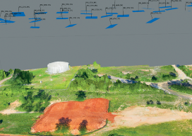
Accuracy With Small UAS Mapping
Two recent advances in heretofore unrelated technologies are giving birth to a new way to perform local-area metric mapping. The first is the development of small, unmanned aerial systems (sUAS), spurred on primarily by the miniaturization of autopilot components. The second is the development of novel algorithms for creating digital surface models from collections of...