Urban mobility in Europe gets a much-needed boost as cities develop digital twins for their road networks
If you ever find yourself riding one of London’s iconic taxis, a chat with the driver will surely turn to the city’s worsening traffic situation. Cabbies should know, because along with other motorists and commuters in the UK’s capital, they are spending more time stuck in gridlock.
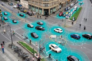
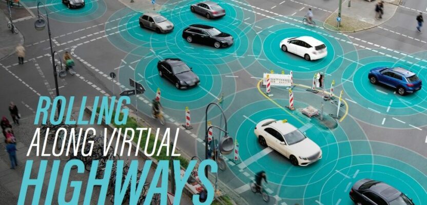
Innovative digital twin technologies can improve urban mobility planning.
Congestion in London is notoriously horrific causing people to lose an average of 156 hours in 2022. That’s roughly equivalent to a full week inside vehicles according to a report by Inrix, a mobility analytics company that examined traffic data from more than 1,000 cities in 50 countries. London tops the logjam list after Chicago (155 hours), Paris (138 hours), Boston (134 hours), and New York (117 hours). So, if you drive or commute every day and don’t live in any of these metropolitan cities, consider yourself lucky.
Yet cities outside London fared no better. During the same year, the hours lost in bottlenecks were relatively high in smaller-sized cities like Bristol (91 hours), Manchester (84 hours), and Birmingham (73 hours). Overall, the average UK motorist spent 80 hours in traffic jams—seven hours more than in 2021.
Aside from causing time delays, traffic congestion burns the environment and breaks the bank. Air pollution levels along busy roads are comparable to gridlock zones where drivers tend to leave their vehicle’s engine running while not moving. Idling vehicles release exhaust fumes into the air and waste an enormous amount of petrol and money. According to the Inrix report, the average UK commuter spent £707 ($895) in lost time and paid £122 ($155) more for fuel due to traffic jams.
The UK’s Transport Minister, Jesse Norman, wants to improve all that by promoting the creation of a digital twin for the country’s transport system. The plans are outlined in the Transport Digital Twin Vision and Roadmap 2035 and were unveiled during the Connected Digital Twins Summit held in London last year.
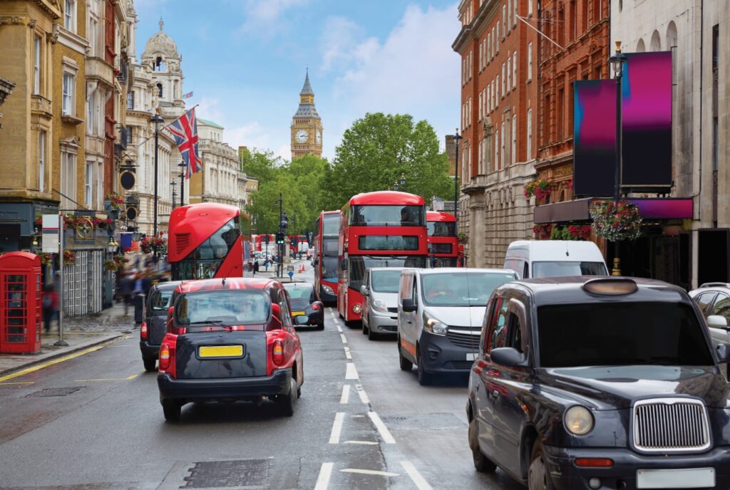
London is one of the most traffic-congested cities in the world.
“The UK is a global leader in transport technology partnering with industry,” he said. “The Vision and Roadmap for Digital Twins shows how the Department for Transport is supporting innovative digital twin technologies for a cleaner, greener, and more efficient transport system.”
Connected Places Catapult (CPC), an accelerator agency focusing on technological innovations for cities and transportation, developed the digital twin roadmap for the UK’s Transport Research and Innovation Board (TRIB), the main government body that coordinates transport-related research activities.
“The use of digital twin technology has the potential to transform the UK transport sector to deliver better outcomes for the user and advance the transition to net zero emissions,” according to the TRIB website.
When the digital twin of the UK’s transport network is completed, it will include several features that will benefit the commuting public. One of them will be the ability to perform real-time simulations of vehicular flows to help road authorities anticipate traffic jams and implement adaptive road controls. Another will be the capacity to optimize the best possible use of multimodal transport and make the movement of both people and goods faster.
The aim of the UK transport digital twin, however, is not only to improve travel times but also to minimize air and noise pollution. For example, Slingshot Simulations, a simulation-as-a-service software company based in Leeds, has received support from the CPC and TRIB in developing the Compass Engine, a digital twin that can run traffic flow simulations and predict the emissions and noise levels based on different traffic scenarios.
Slingshot Simulations has already successfully implemented a case study in Bristol to illustrate how its digital twin technology can rapidly assess the road-by-road impacts at a city-scale. Five other UK companies are now developing transport-related digital twins that will demonstrate how this new technology can deliver useful products for the country’s mobility sector.
The UK’s turn to digital twins seems to be a part of a broader shift by national governments and cities in Europe toward improving their transportation networks via digitization. A survey of urban digitization efforts published in 2021 by researchers from the Technical University of Catalonia, in Spain, found that cities in the old continent are emerging as the main center of new digital twinning developments worldwide.
Today these ventures are proving to be more than just side projects. As fuel prices rise and citizens become more aware of the environmental impacts of their mobility choices, urban leaders in Europe are finding innovative ways to refine their transport infrastructures and transform the quality of city living by virtual replication.
Digital E-urope
Leading the pack in digital twin building is Tallinn, the capital city of Estonia. Being located in the most digitally advanced country in the world may have given this city a huge head start because ever since its independence in 1991, the country reinvented itself from scratch and went fully computerized. In this Baltic country of 1.3 million people, almost all public services are accessible online and no less than 92 percent of households have an Internet connection.
When Tallinn city planners built its city’s digital twin a few years back, they started with a simple 3D mapping representation of the old town. But with advances in lidar point cloud mapping and building information modeling (BIM), its urban digital model now covers the entire city.
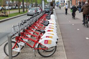
Antwerp’s digital mobility platform can help its citizens choose from various intermodal means of transport, including trains, buses, and even bicycles.
Tallinn’s digital twin provides a useful template for urban planning, analysis, and design. However, because it lacked the ability to simulate changes in urban mobility and build scenarios to improve transport planning, city planners decided to create a fully digital transport twin. They launched it in 2021.
“We reached a point where an additional tool would be very helpful to analyze both traffic and public transportation issues,” urban mobility expert Grigori Parfjonov said in a blog post. He works at the Tallinn Transportation Department, which uses the digital twin of the city’s transport network to predict problems in urban mobility and provide practical solutions to traffic.
Based on the PTV Visum software, a transport planning platform, Tallinn’s pioneering road digital twin allows city authorities to simulate traffic situations as well as evaluate future improvements to the city’s public transport network. The software not only incorporates vehicles in Tallinn’s digital transport model but also includes the movement of pedestrians to improve the mobility experience for every road user.
“The transport model is a digital tool that brings together all available data to help us understand how and when people move around Tallinn,” said Andrei Novikov, deputy mayor of Tallinn. For example, traffic simulations can be used to decide on the vehicular capacity of specific streets and support the upgrading of the city’s public transport network.
Besides Estonia, the UK can also look toward Germany for lessons in digital twin building. Cities such as Stuttgart and Munich are focusing on improving urban mobility and quality of life by digitally twinning their road networks with environmental data.
Stuttgart’s digital twin model, for example, controls and optimizes urban traffic so that pollutant emissions from cars can be reduced. Based on Hexagon’s geospatial enterprise platform and Fujitsu’s cloud services, the city’s twin also monitors parking space occupancy and flood levels. The Stuttgart Urban Digital Twin project also provides city planners with a vast amount of mobility and environmental data, according to Jens Schumacher, head of IT for the Stuttgart Civil Engineering Office. “The IoT analysis platform from Hexagon and Fujitsu will give us the ability to use that data to make smarter decisions for the good of our city,” he said.
Munich’s approach, however, goes even further by incorporating highly detailed geospatial data, including real-time weather data, traffic volumes, and noise or air pollution measurements. This makes its digital twin more dynamic, allowing users to fuse the real and digital worlds with the use of mobile technology.
Christine Kugler, city councilor and head of the Department of Climate and Environmental Protection for Munich, said the city’s digital twin represents a significant stride toward digitized environmental planning to achieve a climate-neutral and low-pollution city. “It allows us to analyze real-time environmental data using our comprehensive digital infrastructure.”
The digital twin of Tallin’s transport network can predict problems in urban mobility and provide practical solutions to traffic congestion.
What makes all these digital twins function is their focus on integrating the geospatial context of the road, the basic building block of any transport-based city model. To have a geospatially correct digital twin means that each segment of the road network is represented in highly accurate dimensions that pays special attention to their spatial location and topology.
Doing so allows urban planners to make use of connected sensors on the ground to capture different types of location-based data and visualize traffic events on the fly, while at the same time apply real-time analytics to support fast and actionable decision making.
The port city of Antwerp in Belgium has been doing just that. Since 2018 its Generic IoT Platform (GIP), developed by IT company Sirus, combines various data in real time from thousands of sensors scattered in the city to improve the intermodal mobility of its citizens. The GIP platform can be accessed via a public website by anyone who needs information on the most efficient route to get them to reach their desired destinations, either by using trains, buses, and even bicycles. In turn, the data generated by users of this smart system has allowed Antwerp to improve its public transportation services and mobility.
The Beaten Road is the Safest
Cities around the world are confronted with the same big challenges to mobility. The first is how to keep up with increasing demand for urban transport as populations grow. According to the World Bank, nearly 70 percent of people will live in cities by 2050 when urban population will double to six billion.
The second problem is rising costs, which may be harder to fix. Building new transport infrastructures in cities can take time to finish and are usually expensive. In the face of these pressing issues, cities must still be able to provide transport systems to support commuters who live in cities.
Investing in digital twins now, therefore, may guide city managers in tackling the challenges of planning, monitoring, and managing urban mobility. With digital twins, city planners can simulate different urban transport options and evaluate their performance before construction begins. This can lower budget costs and optimize the use of scarce open spaces.
The good news is that “the digital twin city market is booming,” as stated in a World Economic Report released last August. And that growing interest of cities to build their own virtual copies is driven largely by the availability of digital data and faster computing power.
Yet the same report also concludes that developing one is a complex undertaking, even in more technologically advanced countries. According to the DUET Project, a European initiative that promotes the use of digital twins in the public sector, there are still several challenges in committing to the use of this mirroring technology.