Tag Archives: cartography

xyHt Magazine December 2016 Issue
Click here to view the December 2016 issue of xyHt magazine.
Map Making: “Can I have a map?”
“Can I have a map?” How often do you get someone ask, “Can I have a map”? I have nothing against making maps; in fact I like it so much that I have made a career out of it. Not just any map either, I’ve made maps for the nuclear, environmental, government, renewable energy, offshore...

xyHt Magazine May 2016 Issue
Click here to view the May 2016 issue of xyHt magazine.
Web Mapping
Part 1, The Basics Children of the millennium will never know that there was a time before the internet when we, the cartographers, engineers, and surveyors had to relate geospatial information through the medium of paper. Although the internet has been around since the late 1980s, it wasn’t until 1996 when the world got the...
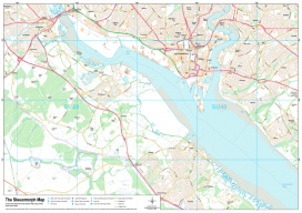
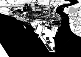
Recreating the Ordnance Survey Explorer Maps with Open Data
The holy grail for many (UK) map users is the Ordnance Survey 1:25,000 scale “Explorer” map. Not only are they easy to read due to the fantastic cartography used, but they also have information which is hard to source such as public rights of way, National Trust & Woodland Trust sites, even wind farms. To...
Why Your Maps Should Get in Touch with Their Feminine Side
Google does it, Apple does it, but do your maps use landmarks to improve users’ familiarity? More to the point, why aren’t popular landmarks a standard GIS dataset? For more than 10 years now we’ve known that the majority of the population use spatial recognition to navigate. When I say “majority.” I mean women and...