Tag Archives: cartography
What’s within a 30-minute Walk – Revisited
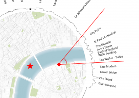
I recently had reason to be in London for a short meeting and walked past London Bridge, looked at the sky around me, and thought, “I wonder how accurate that map I made last year is?” I was fortunate to have my camera phone with me so that I could take a few pictures. The...

Interview with Esri’s Ben Flanagan
Ever wonder who makes those maps you see in the newspaper? Ben has made maps for the Telegraph, the Guardian, and BBC News, and best of all (to me) he’s from the UK! Ben is like a ninja—not many people know about him but those that do are avid fans of his work. It was...
Creating Album Covers with GIS—or Drawing Elevation as Vector Lines
In July 2014, a developer and neocartographer from Scotland created the “Joy Divionesque 3D Map.” This began a four-year onslaught of maps that replicate the style of the iconic Joy Division album cover, “Unknown Pleasures.” How does it work? Essentially the elevation is taken from an underlying terrain or digital surface map as points, which...

My First Trip to the Esri UC
No matter what flavor of GIS you roll, there is no ignoring the annual Esri user conference in San Diego. The highlight is the opening plenary session which is always given by the (co) founder of Esri, none other than Jack Dangermond. To discuss this fully, we have to start at the beginning, which was...

Alison DeGraff Ollivierre
Cartographer, National Geographic Maps Colorado, USA With interests in participatory mapping, outdoor recreation and travel cartography, small-island developing states, climate change, spatial planning, and conservation, Aly Ollivierre spreads her work as a cartographer widely and generously. She’s a cartographer at National Geographic Maps, a freelancer doing cartography/GIS work at Tombolo Maps & Design, and a...

xyHt Weekly News Recap: 7/14/17
From the International Cartography Conference (ICC 2017) ‘Maps Are Alive’: Highlights from the Esri UC plenary