Tag Archives: cartography

xyHt Magazine Digital Edition: December 2021
Like a good surveyor, xyHt‘s December issue covers a lot of ground. This month we bring you stories about surveying, lidar, legal issues and an in-depth look at the emerging post-processing kinematic technology. As always, if you don’t have a subscription to our print edition, or if someone else in the office has snaffled your copy,...

xyHt Weekly News Links: 10/16/2020
How UAVs Make a Difference in Modern ForestryNew Topcon Robotic Total StationEarth Define Maps U.S. TreesNASA to Study Trees Impact on Remote SensingHxGN Content Program delivers airborne DSM to the Federal Agency for Cartography and Geodesy (BKG)Ronda Schrenk to Serve as USGIF Foundation CEO
Creating a Web Map Using QGIS2Web
Almost two years ago to the day I wrote Webmapping 3.5 in which I did a walkthrough of QGIS2Web. Since then, QGIS has grown up, and so has QGIS2Web. In the original blog, I discussed how you could use OpenLayers and Leaflet as basemaps. Now you can use Mapbox, too. The layout is improved and...
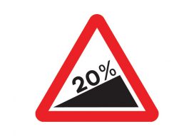
Using Real Road Signs in GIS
At the moment, I am doing a little work with the construction industry that requires road signs and markings placed on a map to show where signs need to move as the site(s) moves through different phases. Now, a real cartographer nerd would say that good graphics and symbolization would negate the need for placing...

Esri UK Conference 2019 Recap
Every year towards the end of May, Esri UK, the UK distributer for Esri software, holds a user conference across the road from Westminster, the home of the UK parliament (when I was there I even got to see Jacob Reese Mogg). It’s held at the QE2 centre, and there are amazing views from the fifth floor which allow...
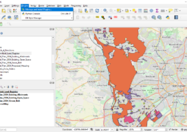
Where on Earth Is the Offset in ArcGIS Pro?
Life used to be nice and easy for us GIS guys. We used to roll out of bed, click start on our GIS software, go back to bed for an hour, and then think about making a nice simple 2D map. Then, all of a sudden everyone starts talking about 3D GIS and being able...