Tag Archives: @Dragons8mycat
Multipurpose GIS with ArcGIS Pro
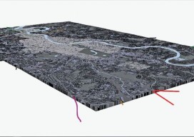
You can now use point clouds and massive geospatial data with GIS through the web and your desktop with new software. Above: London rendered in 3D with London Underground data. For years, point clouds (lidar, laserscan, and multibeam) have been pretty useless to GIS users. When a GIS user had to analyze the data, often...
Multipatches, Point Clouds and Meshes
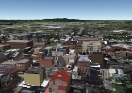
A Guide to 3D GIS Data Formats Moving your GIS to 3D is a daunting task. Not only are there all the vertical issues to take into account, but also a whole new world of jargon, which can, at times, be quite overwhelming. In this post you’ll find a few of the data formats that...
Back to the Future
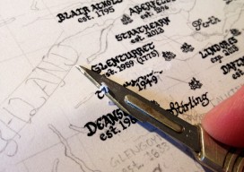
An Interview with the hand-drawn map creator, Kevin Sheehan There isn’t much you can’t do with digital media nowadays, from effective maps using shadows and drop effects to using graphic-design packages to make the map “pop”—except for one thing—capturing that hand-drawn style, the way that the pen line moves in and out from the pressure...
Webmapping 3.5: A Recommendation for your First Step Into Web Mapping
It’s been almost a year since the web mapping series I did. Hopefully, by now, you’ve had a chance to have a little play with some of the options. If not, don’t worry, I have a sneaky confession to make… I held back on one option, QGIS2WEB, which is a wysiwyg plugin for QGIS. Why...
Vertical Transformations and GIS
You know those moments where you are sitting in a pub, the office, or at a friend’s house and you say something, then suddenly wonder why you haven’t thought of it before? I had that very issue in the Brew Dog pub near Spitalfields in London, UK a couple of weeks ago. You see, I...
Map Making: “Can I have a map?”
“Can I have a map?” How often do you get someone ask, “Can I have a map”? I have nothing against making maps; in fact I like it so much that I have made a career out of it. Not just any map either, I’ve made maps for the nuclear, environmental, government, renewable energy, offshore...