Tag Archives: drone
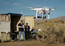
BVLOS
Beyond visual line of sight is the next frontier for UAVs. The FFA’s Part 107 rule allows for routine civil operation of small unmanned aircraft vehicles (UAV) in the National Airspace System (NAS) and provides safety rules for those operations. Since this implementation almost two years ago, more than 70,000 drone pilot applications have been...
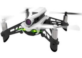
Why Your First Drone Should Be a Hobby Drone
A low-cost way to get hands-on UAS experience is to purchase a hobby drone and practice with it before making a bigger investment in a commercial-grade unit. I’ve talked to UAS professionals who agree . Why? The low cost makes it easy to afford and less painful should you crack it up. And, trust me...

xyHt Weekly News Links: 11/3/17
Garmin® acquires Navionics® SimActive Automates Direct Georeferencing GeoSLAM Launches Time & Cost Saving 3D Mobile Laser Scanners at Dallas Fall BIM Forum 2017 Singapore International Robo Expo Returns Bigger in 2017: Showcasing Latest Robotics Innovations USDOT launches Drone Integration Pilot Program Velodyne LiDAR and BoE Systems Partner for Integrated UAV-Borne LiDAR in Geospatial Data Collection
Weekly xyHt News Links: 10/27/17
Septentrio launches the AsteRx-m2a and AsteRx-m2a UAS at Commercial UAV Expo WiBotic Announces a New Lightweight Onboard Charger Ideal for Wireless Charging of Smaller Drones Teledyne Oceanscience Introduces a new USV! Welcome to Z-Boat 1250! Solve Gas Detection Problems with Microdrones mdTector1000 CH4 Commercial UAV Expo and Drone World Expo Come Together in 2018 OGC...
xyHt Weekly News Links: 9/29/17
Teledyne Optech and IGI announce new cooperative agreement and first product offering Hemisphere GNSS Debuts Next-Generation S321+ and C321+ GNSS Smart Antennas Septentrio unveils the new Altus NR3 at InterGEO GeoSLAM Launching Enhanced SLAM Software and Next Generation Mobile Scanner at InterGEO 2017 INTERGEO 2017 Berlin: Geo-IT-event officially opened Applanix Announces POSPac Cloud for Mobile Mapping...
xyHt Weekly News Links: 9/22/17
Phase One Industrial Introduces 190MP Aerial System Orbit GT to showcase new v18 for Mobile, UAS, Indoor and Aerial Mapping at Intergeo, Berlin Hosting massive geodata made easier by new cloud solution LizardTech Awarded U.S. Patent for LiDAR Point Cloud Compression senseFly to launch industry-specific solutions at INTERGEO 2017 Measure’s First Drone Services Franchise Opens...