Tag Archives: drones

xyHt Weekly News Recap: 06/10/2022
IMAGINiT Develops Additional Time-Saving Utilities for Autodesk Revit Surveying Shallow Water from Space Trimble Introduces OEM GNSS Receiver Module for Industrial Autonomy Applications Geo Connect Asia 2022 Hosts Close to 2,000 Professionals from 36 Countries Drone Nerds Introduces Advanced Mapping and Surveying Solution, the ViDoc RTK Rover Expedition to Deepest Point on Earth Will Collect...
xyHt Weekly News Recap: 05/27/2022
New Energy Performance Data in XMAP Helps Tackle Climate Change Trimble Introduces High-Accuracy OEM GNSS Receiver Module Atmos Integrates Topcon Hardware to Create All-in-One Surveying Solution Fugro’s Lidar Geo-Data Supports OPW’s Irish Coastal Resilience Strategies Censys Technologies and American Aviation Regulator Complete BVLOS Emergency Response Project Applications Invited for URISA’s Vanguard Cabinet (URISA) Australian Company...
xyHt Weekly News Recap: 05/13/2022
Geo Week 2023 is Already 80 Percent Sold Out XAG Promotes Drones in Vietnam to Boost Rice Farming While Cutting Fertilizer Use Bowman Expands Transportation Infrastructure Services with Acquisition New Leica Pegasus TRK Makes Mobile Mapping Smart, Autonomous and Easy RIEGL’s Laser Scanning Sensors on Display at GEO Business in London Teledyne FLIR Defense Introduces New Laser Target Designator...
xyHt Weekly News Recap: 05/06/2022
NSPS to Host Virtual Town Hall on Davis Bacon Act Regulations LiDAR for Drone 2022 Conference Set for June 13-14 in France World’s First Expandable Wing UAS Launches at AUVSI XPONENTIAL Army Corps of Engineers Picks Aero-Graphics for Geospatial Mapping and Surveying High precision mapping and automated workflows IDS GeoRadar launches cloud-based AI solution AiMaps...
xyHt Weekly News Recap: 04/29/2022
NSPS Joins Coalition Effort to Raise Concerns on GPS Interference with President Biden and Congress Association for Geographic Information Celebrates Return to In Person Events White House Wants to Counter the Use of Drones in the U.S. USGIF Announces New Scholarships and a New Working Group Focused on Diversity, Inclusion, and Belonging Auterion Delivers New...
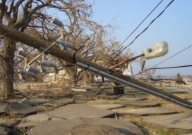
Surveying, Drones, and Danger
Experts say drones carry the promise of keeping the electrical grid safe amid increasingly intense storms The greater number and intensity of severe storms in the United States has communities rethinking their infrastructure. They’re making streets and parking lots permeable to absorb excess rainfall and rebuilding natural watershed features that help prevent floods. With the...