Tag Archives: hydrography

This data was gathered in shallow water in and around Bristol docks, UK and processed with GeoSwath, an echosounder by Kongsberg Maritime.

Capturing More with Shallow-water Multibeam

Interferometric sonars are providing a new tool for the hydrographic surveyor in shallow to medium-depth water applications. As we begin to return to normalcy after the deepest recession of most of our lifetimes, many ports, coastal authorities, and inland waterways are starting to look at infrastructure projects that have been kept on hold, and they...

Mapping the Scottish Seabed

Six companies collaborate on a project to bury fiber optic cables under the Scottish seabed, stitching segments using hydrography, bathymetry, and surveying. On land, surveyors face challenges due to rough terrain, human activity, weather, and more. Usually, however, the ground beneath their tripods doesn’t move, they can physically occupy positions, and the air between them...

Hydrography

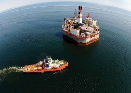
Above: Corporate social responsibility helps to ensure safety of the environment at a complex interactive drilling operation. Timely Delivery of Data and Products, Marine Spatial Planning, Increased Trusted Partner Resources Here’s a frameworkfor hydrography’s future. Start with the vision of a survey fleet, assisted by unmanned platforms, permanent seafloor installations, remote sensing, and trusted partner...

From Shore to Floor

Today’s technology records depth from land to deep waters accurately and efficiently. More than 90% of the world’s trade is carried by sea, according to the International Maritime Organization. Therefore, accurate and up-to-date charts of coastal waters for ship navigation are vital for world commerce. The current expansion of the Panama Canal, which will double...