Tag Archives: InfraWork’s 360
3D Software, Not Really Like CAD at All
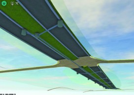
Above: InfraWorks 360 uses engineering rules to ensure that vertical and horizontal curves in infrastructure elements have the proper radii. Take a close look at Autodesk’s InfraWork’s 360, an unusual 3D modeling software. Editor’s note: For many firms and practitioners of surveying, photogrammetry, mapping, and remote sensing, traditional deliverables to AEC clients have focused on...