Tag Archives: ITRF
Shake, Rattle & Roll: Disruptions to the Geodetic Fabric
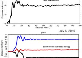
On July 4, 2019 the desert region near Ridegcrest, California was hit with a magnitude 6.4 earthquake, resulting in minor damage in the area, most significantly to the infrastructure at the Naval Air Weapons Station at China Lake. Approximately 44 hours later on July 6th, a larger earthquake of magnitude 7.1 struck the region, causing...

2022
The NGS discusses the upcoming national spatial reference framework modernization. Reference framework shift happens. The National Geodetic Survey (NGS)—the federal steward of the National Spatial Reference Framework (NSRS)—is planning a major (if not fundamental) update of the framework. This pending update is common knowledge among geodetic, surveying, and other geospatial communities. Among the information circulating...