Tag Archives: marine

xyHt Weekly News Recap: 06/17/2022
IMAGINiT Develops Additional Time-Saving Utilities for Autodesk Revit Surveying Shallow Water from Space Trimble Introduces OEM GNSS Receiver Module for Industrial Autonomy Applications Geo Connect Asia 2022 Hosts Close to 2,000 Professionals from 36 Countries Drone Nerds Introduces Advanced Mapping and Surveying Solution, the ViDoc RTK Rover Expedition to Deepest Point on Earth Will Collect...
Hydrography
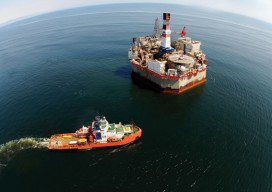
Above: Corporate social responsibility helps to ensure safety of the environment at a complex interactive drilling operation. Timely Delivery of Data and Products, Marine Spatial Planning, Increased Trusted Partner Resources Here’s a frameworkfor hydrography’s future. Start with the vision of a survey fleet, assisted by unmanned platforms, permanent seafloor installations, remote sensing, and trusted partner...
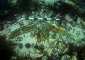
Kennemerland: Repositioning a Dutch East Indiaman
The Kennemerland is now designated as a Historic Marine Protected Area on account of the national importance of the wreck. Recently I was part of a team of archaeological divers sent to Out Skerries by Cotswold Archaeology on behalf of Historic Scotland. We were tasked with checking, updating, and geo-referencing the existing plans of the...