Tag Archives: oblique

3D Cities from a Single System
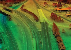
Above: This screenshot is of CityMapper output. A look at the hybrid airborne system that combines lidar with oblique and nadir imagery. Over the last five years I’ve built and used a lot of 3D GIS and BIM models. Almost all of this has required the capture of stereo imagery and oblique imagery and a...
Satellite Imagery’s Impact
Above: The highest resolution of commercial satellite imagery is still more than an order of magnitude lower than the highest resolution attainable from aerial platforms. Keystone Aerial Surveys, Inc. developed this digital surface model from 1.75 cm digital imagery taken with a low-altitude flight. The resolution is sufficiently high to enable its use for mapping...